Welcome to SENDITUR.COM · paths · routes · tourism

![]() Difficulty-Moderate
Difficulty-Moderate
![]() 3:50 h.
3:50 h.
![]() 9.6 km.
9.6 km.
![]() Difficulty-Moderate
Difficulty-Moderate
![]() 3:50 h.
3:50 h.
![]() 9.6 km.
9.6 km.
In the Iberian system, between the provinces of Zaragoza and Soria, is the Moncayo Natural Park, a protected area that houses a rich ecosystem, habitat of a large number of species, both animal and plant. The park extends around the mountain that shelters it and gives it its special uniqueness making it an ideal place to enjoy its many trails, one of them is the Ascent the Moncayo that will take us to the top of this mythical mountain showing us the marked differences that the landscape of this mountain has, depending on the height we are.

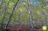
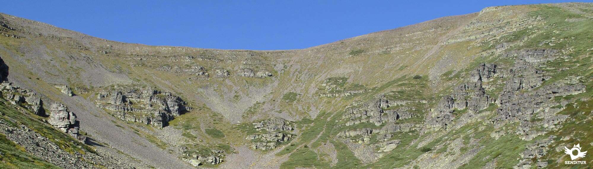
The route with 9.6 km starts from the last public parking that we will find shortly before arriving at the Sanctuary of Our Lady of Moncayo, to undertake from here a tireless climb that will take us to the top. On our arrival at the Sanctuary from the bottom of the valley we have already been able to observe the variation in the landscape that surrounds us as we gain height, and that is, while in the lowest part of the mountain are the oak trees that predominate, as we gain height they give way to beech forests that above give way to the thick pine forests where the path that leaves the Sanctuary winds. This mountain path makes us gain height gradually until, without warning, the pine forests and the shade they provided disappear to leave us in front of the impressive San Miguel Cirque, from where we can contemplate the entire north face of the mountain. From here, and without the company of the trees that covered the slope of the Moncayo, the hard climb begins, following the zigzagging line that marks the stony path that struggles to advance in the ascent.

On both sides, we will find two of the three cirques of glacial origin that still resist in these latitudes and the tour will show us them taking us from one to the other as if we did not want to forget where we are. The landscape that surrounds us well deserves repeated stops to enjoy the views, at the same time as we recover our breath, the valley of the Ebro, the circuses or the gendarmes that rise on the opposite side of our ascent will allow us to enjoy a climb that is undoubtedly demanding. The end of the path takes us to the top of the mountain that connects San Miguel Peak with the different peaks, such as La Lobera, that make up this lonely mountain range. Right there we will be able to realize the significant difference that both slopes have, not only because of their vegetation but also because of their geological characteristics that make clear to us the natural border that this mountain makes between climates of very different characteristics, such as the Eurosiberian of the north face and the Mediterranean of the south. A comfortable and smooth final stretch will definitely bring us closer to this singular summit from where on days of good visibility we will be able to enjoy the magnificent panorama that the Moncayo offers to those who climb it.

In the middle of Moncayo, inside its entrails, live some evil Gnomes who will manipulate our reason if we ever meet them on our journey, in order to protect the treasures they keep hidden inside this mountain. These Gnomes, whose entrances to their hiding places are hidden in the snow, sometimes descend from the mountain, sowing their mischief wherever they go and terrorizing all those they meet on their way.
Given its extension, there are many possibilities to access the Moncayo Natural Park, Tarazona, Vera de Moncayo or Agreda are some examples. The N-122 between Zaragoza and Soria is where we will find the main access to the park. The SO-382 leaves Tarazona towards Santa Cruz del Moncayo and brings us to the limits of the park where we will have to turn aside to go towards the Center of Interpretation of Agromonte. This same road, but in its other direction, comes from Agreda in the direction of Vozmediano to lead us to the detour to the interpretation center. Another option is found in Vera de Moncayo, a town near the route of the N-122, from where the road leaves in which we will find the detour to the park and also links this town with Alcala de Moncayo and Añon de Moncayo from where we can also reach it. Once in the interpretation centre we will begin a long ascent along a forest track, initially asphalted, which will bring us closer to the sanctuary. On the route of this track we will find places specially prepared for parking, as it is forbidden to park anywhere else but in them. These car parks are interspersed in the ascent increasing the capacity of the park. The track, already of earth, continues its ascent until arriving at the last parking where we will be able to leave our vehicle, since the parking of the sanctuary is of private use. We will identify this last parking area because the track that brought us here leaves the forest to border a rocky area and the cliff that hides the sanctuary.
Without a doubt, the demanding slope will test our partner's resistance. It is important for his safety to control his effort and prevent him from going off the course, especially on the trail that goes up through the tinderbox. Pay special attention to your legs, the tinderboxes are not the best floor for them and although it is not too much distance it can take its toll, some boots or protectors are not superfluous in these areas.
Water and some food are a must, as there will be no water points along the way where you can drink, and the heat added to the effort will make you dehydrate quickly.
We must not forget that we are in a protected natural area, which has a specific regulation for its enjoyment and we must review it. There are many pets that we will surely find on the way and we must add the usual inhabitants of the area, but it is more difficult to find them because of the influx of people who make the journey.
We start the tour in the last parking lot (0h 00min) that we find just before arriving at the Sanctuary.

From here we must follow the route that marks the track that brought us here and skirt the cliff that hides the enclosure.

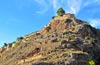
The enormous building that houses the refuge and the Sanctuary of Our Lady of Moncayo (0h 15min), marks the end point of the track that extends for a few more meters.

The tour continues next to the building, bringing us closer to the beginning of the path that will take us into the forest. Leaving on our left the path that goes down to the parking lot of the Sanctuary, we quickly begin to realize the long climb ahead of us.

Soon we find ourselves walking among stones trying to follow the path that ascends to a new crossroads, making us leave the Shrine building behind.

When we arrive at this junction, our route turns sharply, facing the shelter again and leaving aside the path that would take us to Collado Bellido if we followed it. At our feet we already have the roof of the shelter and in front of us the high part of the enormous cliff that shelters the sanctuary.

A long stretch awaits us inside the forest that already lets us intuit the continuous zigzags that the itinerary draws trying to make us gain height with the minimum effort possible.

There will be several shortcuts that not so long ago crossed this forest, shortcuts that today are cut by small stone walls in order to avoid disorientation and preserve the environment that was already beginning to be affected by the passage of so many people everywhere.

Following the comfortable, well marked path, we will see ourselves step by step gaining height and losing some of the protection that the trees offer us.

After a while they will definitely stop accompanying us, leaving us at the doors of the San Miguel Cirque, where we will take note of what we have ahead of us.

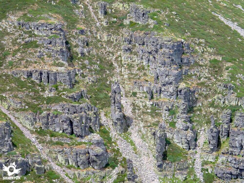
Here the path is divided in two and the wall that cuts the way to the cirque is partly dismantled by the mountaineers who follow this harder route in winter, but although it does not seem so, it is safer than the route followed in summer.

We continue on the left to begin the real ascent of the Moncayo or San Miguel Peak. This route is not advisable with snow or ice and leads us through a rocky area towards the limits of the forest that extends for a few meters in search of more height.

We quickly start with the continuous turns that like long curves climb the mountainside leaving almost at once the protection of the trees that are already under us.

The route as soon as it takes us away from the San Miguel cirque, as soon as it takes us closer to it, making us gain height with every step. Concentrating on the effort we are making, we hardly notice the magnificent spectacle we have behind us. The park stretches out at our feet, merging with the wide valley of the Ebro wherever we look.

We soon realize that we are climbing up the shoulder that separates the cirque of San Miguel from the cirque of Gaudioso, a fact that the path insists on reminding us by continuously taking us from one to the other.

The ascent is long and some wooden posts make us fall into the error that we are already at the end of it, of which we still have a long way to go.

The ascent continues and seems to be bent on separating us from our objective by moving away from it to lead us to the end of the path where the detour is (2h 10min) that will take us to the true end of the ascent.

A few milestones mark this point as on the way back it is easy to skip the start of the descent, especially if there is fog.

After recovering our breath, we headed for the distance that still separates us from the summit. Ahead, a soft up and down slope leads us to the top of an unknown hill, Cerro San Juan, to start the final ascent after descending a few meters.

After a longer than expected final stretch, we arrive at the summit of Moncayo or San Miguel Peak (2h 30min) where we will recover our strength while enjoying the spectacular views that this mountain offers us.

We return following our steps to find the detour (2h 40min), the beginning of the path where we will begin the rapid descent that takes us to the bottom of the circus. From there we will go back into the forest following the path that leads us to the Sanctuary of Nuestra Señora Del Moncayo (3h 40min) and from there to the parking lot (3h 50min) where this route ends.
 Distance. 9.6Km
Our starting point, among other factors, will determine the actual distance of the route.
 Time. 3:50h
Starting the route soon, with the possibility of having the necessary time, we can assume the ascent calmly making as many stops as we need to get to the top. In the event that the last parking spaces are full and we have to leave our vehicle in the lower ones, in all of them we will find paths that lead us to this last parking lot shortening part of the way, paths that we should not confuse with the other routes that the park has. Depending on where we start, we may have to spend up to 5h 30min to complete the route.
 Time of year
It is not advisable to do this route with snow as it is a dangerous ascent due to the exposure it leaves us to possible falls, as we travel between the two circuses that leave us almost vertical walls on each side without much margin for error. On the other hand, without snow or ice, it becomes a fairly affordable route if we have a reasonable physical condition giving us the opportunity, not without effort, to enjoy a great mountain and its landscapes, surrounded by colorful contrasts depending on the time of year we decide to climb it. With good weather and days of good visibility, more common in these periods, the panoramic views can be extended considerably showing us quite distant places.
 Required equipment
Adequate footwear will protect us from bad footfalls or blows and will contribute to facilitate our descent, boot or trekking shoe depending on our experience and the weather conditions we find would be more than enough. Adapt our equipment to the time of year without forgetting that we are in a mountain very prone to sudden changes in the weather and with a great difference in it, depending on whether we are in one or another slope. Wind breakers and some warm clothes, glasses and protective cream cannot be missing along with water and food in the backpack. Although the path is very well defined is not too much that we carry a map of the area and the compass along with the GPS and the tracks of the route in case we get the fog. Consult our list of material and equipment for hiking. Read more.
 Difficulty. Moderated
Physical
The demand of the unevenness to be overcome, in normal conditions, is its greatest difficulty, although the relatively short distance of the route allows us to face it calmly, taking the necessary pauses to save it, not without effort. It is important, especially in summer, not to forget to hydrate and protect ourselves from the sun as much as possible, as otherwise the harshness of the route increases and can take its toll. The most demanding part of the ascent goes from the circus to the top where we must face a path that runs winding through an uncomfortable field. There are many deceptive shortcuts that cut from one zigzag to the other, shortcuts that if we are not used to mountain routes it is not advisable to fall into their trap to save a few meters. The most certain thing is that we will fall into a climb that, in itself, becomes long and heavy.
Severity of the environment
Without technical complications in normal conditions and as long as we do not leave the marked route we should not have major complications, although it is true that we must be aware of possible falls of stones that can be produced in the ascent next to the circus, especially if someone is impatient and shortens the route. With rain or wet rocks, we will have to take extreme precautions and avoid, even more, stepping on the smooth slabs to avoid falls and slips. The roots of the trees in the stretch through the forest is another factor that we must take into account and be careful not to stumble. We must not forget that we are in a changing environment subject to uncontrollable factors that can affect our safety.
Orientation
The route is well defined in its entirety. It also has yellow and white marks that indicate the route and stone walls that cut off the path in the detours that we should not take. At the end of the ascent path, when we go out to the ridge between summits, it is important to take references, since with fog and although there are several milestones that mark it, it is extremely easy to skip the beginning of the descent. The apex of the circus from the summit of the Moncayo can serve us as an improvised guide, always with the safety distance, to reach without problems the beginning of the path in case of poor visibility. The entrance to the forest when we reach the lower part of the circus is another of the points where we can find difficulties if we leave the marked path. On the trail there will be many shortcuts and alternatives that we will find, many of them in worse condition than the proposed route and that can lead us to get lost, especially on the way down.
 |
 |
 |
 |
 |
| 1-Parking | 0:00h | 1568m | 0Km | 30T 597796 4627764 |
| 2-St. of Our Lady of Moncayo | 0:15h | 1620m | 0.8Km | 30T 598253 4627189 |
| 3-Detour | 2:10h | 2265m | 3.7Km | 30T 597214 4626168 |
| 4-Moncayo o Pico San Miguel | 2:30h | 2314m | 4.8Km | 30T 596414 4626798 |
| 5-Detour | 2:40h | 2265m | 5.9Km | 30T 597214 4626168 |
| 6-St. of Our Lady of Moncayo | 3:40h | 1620m | 8.8Km | 30T 598253 4627189 |
| 7-Parking | 3:50h | 1568m | 9.6Km | 30T 597796 4627764 |
Coordinates UTM Datum WGS84

 Slope: 1586m
 Slope +: 793m
 Slope -: 793m
 Maximum altitude: 2314m
 Minimum altitude: 1586m

This sketch of the route is not made to scale nor does it contain all the information relating to the area, it is merely indicative.

![]()
This schematic with the path is approximate and has been created from the derived cartographic base © Instituto Geográfico Nacional "Cuadrante 352-1 1:25.000"
Senditur has manipulated the tracks to correct the aberrant points that may exist, caused by problems with the reception of the GPS signal. In any case the tracks are always approximate. SENDITUR encourages you to use the new technologies within your reach, using them as support and consultation in your activity, not basing the realization and orientation of the same only and exclusively on them, since they may see their functioning altered by very diverse causes, not functioning correctly and their indications may not be precise.


Para una buena salud montañera como mínimo un gran monte al año. http://alavaentusbotas.blogspot.com.es/2016/09/vuelta-por-el-techo-del-sistema-iberico.html A este le toco el año pasado.


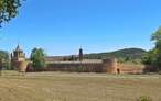
Beautiful stone garden, one of the main Cistercian foundations in Spain
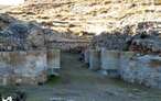

First Cistercian monastery to be established in Spain


¿Did you know that...
The Moncayo Natural Park was created as a protected area in 1927 and has been gradually expanded to over 11000 hectares. This consideration and the actions carried out for its conservation have contributed to recover and reconvert a space, practically without arboreal presence, in what we know today, achieving that autochthonous species return to have an important presence, lost in the past by the action of the man on them.
Don't miss out...
The area has many natural and cultural attractions, such as Tarazona, where we can discover its important historical and artistic heritage or the interesting Royal Monastery of Santa Maria of Veruela, known among other things for its relationship with Gustavo Adolfo Becquer, who lived for long periods in his hostelry.


From the commitment of SENDITUR with Nature and the respect to the balance of the environment, SENDITUR urges you to travel in a responsible way, with low environmental impact and respecting at all times the Natural, Cultural and Social environment wherever you go.

Besides sharing with all of us your experience on the route we would be grateful if you could write to us to inform us of any erroneous or outdated information you may have found, or simply to let us know what you think at Thank you.
This route has been carried out in the field by SENDITUR on 29-06-2018. The route may vary greatly depending on the time of year, weather conditions and terrain, as well as the actions of third parties and the evolution suffered in the natural environment where it is located. All opinions, advice and/or assessments made by SENDITUR in their descriptions are for guidance only and are subject to and/or refer to the specific conditions of the specific day of the route, referring to that specific day, taken from trained people, with the appropriate experience and with a high level of physical and technical preparation as a reference, as well as correctly equipped.
All the times are approximate and take an orientative character, the stops have not been taken into account, no matter how small they are. All the information related to the route, texts, images, videos, maps, diagrams, tracks, towns, and places of tourist interest are published as a guide, and may not coincide with the current state of each place. Before undertaking any activity, assess your technical knowledge, your physical condition, find out about the weather and the variations that the route may undergo, equip yourself correctly, be prudent and responsible at all times, and do not exceed your capabilities. SENDITUR is not responsible for any misuse or inappropriate use of the comprehensive guides of its routes and/or publications as well as its electronic guides, nor for any variations in their descriptions for the aforementioned reasons, and recommends that everyone be responsible and prudent in carrying out the activity. We also encourage you to read books and specialised guides to complement the information described above.
Continue watching …


.jpg "Go to Royal Monastery of Santa María of Veruela")
.jpg "Go to Aguarales of Valpalmas")