Welcome to SENDITUR.COM · paths · routes · tourism


![]() Difficulty-Low
Difficulty-Low
![]() 0:45 h.
0:45 h.
![]() 3 km.
3 km.
![]() Difficulty-Low
Difficulty-Low
![]() 0:45 h.
0:45 h.
![]() 3 km.
3 km.
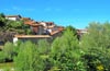
At the gates of the Roncal Valley, nestled between the magnificent cliffs of Borreguil and the Virgen de la Peña, which serve as an unbeatable home for numerous rocky birds, including one of the largest colonies of vultures in Europe, the Foz of Burgui, carved for thousands of years by the tireless Esca river, awaits us. An interesting natural reserve that adds to its important landscape values a rich and important history.

The route with only 3 km, transports us from the very gates of the town of Burgui 0 km to the interior of this imposing gorge. The old medieval bridge of Burgui allows us to cross the Esca river while we contemplate the small dam or port by where, from time immemorial, the Navarrese Almadieros descended on their peculiar boats in their eagerness to transport the coveted wood from the thick Pyrenean forests to the valleys. Today we can remember this symbol of the Pyrenean culture thanks to the Day of the Almadía, a recognition and tribute to this unique trade. As soon as we cross the Esca river, we are invited to take a detour to visit the Basari fir tree, another of the treasures that this land holds, although what undoubtedly catches our attention is the reproduction of the raft that we can contemplate next to the path that runs along our route of the Foz of Burgui, which coincides with the Promenade of Crafts. A route that will take us, following the downstream course of the river, to recall crafts and old trades that used to take place in these lands. Following the encementada track that gains height with calm while it makes us leave behind the almadía and Burgui, we arrive at the corner that reminds us of other hardened workers, the charcoal burners, showing us a reproduction of a small charcoal burner next to a small oven of bread, task not at all easy for these places.

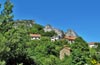
We continue the route seeing ourselves forced to say goodbye to the comfortable rink to go to the restored refrigerator from which they extracted the precious ice, an enormous communal fridge that will allow us to make a good idea of the laborious process. From here and back to the route, since we have had to divert a few meters, we start the path that leads us to the last of the trades that this walk honors, the calero. A small lime kiln tells us about the importance and uses that lime has had in the rural world and the laborious work it took to obtain it. We say goodbye to the Promenade of Crafts and Trades to walk calmly along the path that enters the Foz of Burgui. Surrounded by the thick vegetation, the route allows us to contemplate the vertical walls that surround this natural place. The marked trail is gaining height with the river at our feet while we are observed by the rupicolae that fly over our heads. After saving some area of the trail something decomposed we find the privileged viewpoint 1.5 km from which to contemplate the golden eagle, the bearded vulture, the Egyptian vulture, the peregrine falcon, the vultures or the chough pequirroja, without forgetting the impressive panorama of the steep gorge excavated by the river Esca. Once we have enjoyed this singular spot, all that remains is for us to return on our steps to reach Burgui again, 3 km away, and then to put an end to our visit to this region of Navarre.

Legend has it that Abderramán's troops, after being defeated in Poitiers, returned to the peninsula, sowing panic in their wake. A young couple of shepherds cared for their flock carelessly when a Muslim army outpost surprised them. The young shepherd confronted them, forcing his beloved to flee, knowing the troops that the Saracen soldiers were carrying out as many women as fell into their hands. The heartbroken girl could do nothing but see how the soldiers killed her beloved. The young shepherdess, prey of the anxieties to avenge her beloved and to defend her land, cut her braids, dressed herself as a man and dressed the people so that they would rise up in arms against the invading army. Such was the intensity of the battle that Abderramán himself was surprised by the throws of the combat, seeing himself at the mercy of the hoarse warrior who did not hesitate to kill him and show as a symbol of victory from the top of the bridge the decapitated head of Abderramán, thus culminating his revenge and the defense of his land.
Burgui can be reached by following the A-137 from Sigües, a town through whose surroundings the A-21 passes between Pamplona and Jaca. This same road A-137 but in the opposite direction reaches Burgui from Roncal and Isaba among others. Burgui is also reached by the NA-214 and the NA-2130 from Navascués and Güesa respectively, both in the middle of the NA-178 that joins Lumbier and the A-21 with Ochagavía and Ezcároz. Once there and in the proximities of the bridge where the route begins we will find in the course of the road as it passes through Burgui an area fitted out as car parks.
Quiet route for our friend in which we can not get lost as we pass areas where the vegetation hides the steepness of the terrain, we also have to add the vehicles that at first we can find.
We will only find water points at the beginning of the route, although this is relatively short is not too much to take something for him.
Except for a few pets and the birds that flew over our heads we would not have to find any extra complications.
 Distance. 3Km
Our starting point will mark the actual distance to be covered.
 Time. 0:45h
Without great slopes only the time of the route should increase us the minutes that we use in each stop of the itinerary, and these yes that they are a few.
 Time of year
The route has different attractions that make it interesting throughout the year, the birds, the landscape or the different points where the reproductions and restorations of the appendages that used the different trades that were concentrated here, are more than enough values to visit the area.
 Required equipment
Initially we are looking at a walk on a trail without great complications in which a pair of hiking shoes should be more than enough. Nor can we lack some water, especially in summer, as there are no fountains except at the beginning. The camera will also be a good companion for adventure and we can not forget to protect ourselves from the sun that although it does not seem warm enough. Consult our list of material and equipment for hiking. Read more.
 Difficulty. Low
Physical
Neither the distance nor the slope are or should be a problem, since except for some short ramp we will not find greater demands along the route.
Severity of the environment
The traffic from the road at the beginning of the route is or will be the great danger of this Navarrese trail. It is true that we must not forget that, especially in the stretch of trail, we pass between large vertical walls and although the trail is wide enough we will pass areas exposed and steep in which the trail and vegetation is responsible for giving us enough margin, as long as we respect the limits that it marks us.
Orientation
A linear route with hardly any crossroads where the few that exist are usually well signposted. However, the descending course of the river can serve as a reference in case of doubt in any of them. At the beginning, in the bridge, we will also have signals and informative cartels that are added to those of the different routes that cross the zone. Watch out from the viewpoint of the gorge onwards there are no longer any signs.
 |
 |
 |
 |
 |
| 1-Burgui | 0:00h | 610m | 0Km | 30T 663533 4731621 |
| 2-Lookout | 0:25h | 626m | 1.5Km | 30T 662674 4730577 |
| 3-Burgui | 0:45h | 610m | 3Km | 30T 663533 4731621 |
Coordenadas UTM Datum WGS84

 Slope: 58m
 Slope +: 29m
 Slope -: 29m
 Maximum altitude: 626m
 Minimum altitude: 610m

This sketch of the route is not made to scale nor does it contain all the information relating to the area, it is merely indicative.

![]()
This schematic with the path is approximate and has been created from the derived cartographic base © Instituto Geográfico Nacional "Cuadrante 143-4 1:25.000"
Senditur has manipulated the tracks to correct the aberrant points that may exist, caused by problems with the reception of the GPS signal. In any case the tracks are always approximate. SENDITUR encourages you to use the new technologies within your reach, using them as support and consultation in your activity, not basing the realization and orientation of the same only and exclusively on them, since they may see their functioning altered by very diverse causes, not functioning correctly and their indications may not be precise.


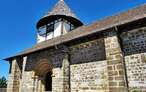
Pilgrimage destination in honour of the patron saint of Navarre, Saint Francis Xavier


¿Did you know that...
Not far from Burgui took place the famous battle of Olast, in which the troops of the leader of the Caliphate of Cordoba, Abderraman, faced the troops of the Roncal Valley, being defeated. Abderraman was taken prisoner and beheaded, which is why the coats of arms of the villages and the Roncal Valley usually include a head with Arab features on a bridge with three arches.
Don't miss out...
The Día de la Almadía, which takes place in Burgui every year at the end of April and the beginning of May, consists of several rafters descending the river Esca during a route that ends at the medieval bridge in the town of Burgui, Navarre, after the waterfall of the dam.


From the commitment of SENDITUR with Nature and the respect to the balance of the environment, SENDITUR urges you to travel in a responsible way, with low environmental impact and respecting at all times the Natural, Cultural and Social environment wherever you go.

Besides sharing with all of us your experience on the route we would be grateful if you could write to us to inform us of any erroneous or outdated information you may have found, or simply to let us know what you think at Thank you.
This route has been carried out in the field by SENDITUR on 18-08-2020. The route may vary greatly depending on the time of year, weather conditions and terrain, as well as the actions of third parties and the evolution suffered in the natural environment where it is located. All opinions, advice and/or assessments made by SENDITUR in their descriptions are for guidance only and are subject to and/or refer to the specific conditions of the specific day of the route, referring to that specific day, taken from trained people, with the appropriate experience and with a high level of physical and technical preparation as a reference, as well as correctly equipped.
All the times are approximate and take an orientative character, the stops have not been taken into account, no matter how small they are. All the information related to the route, texts, images, videos, maps, diagrams, tracks, towns, and places of tourist interest are published as a guide, and may not coincide with the current state of each place. Before undertaking any activity, assess your technical knowledge, your physical condition, find out about the weather and the variations that the route may undergo, equip yourself correctly, be prudent and responsible at all times, and do not exceed your capabilities. SENDITUR is not responsible for any misuse or inappropriate use of the comprehensive guides of its routes and/or publications as well as its electronic guides, nor for any variations in their descriptions for the aforementioned reasons, and recommends that everyone be responsible and prudent in carrying out the activity. We also encourage you to read books and specialised guides to complement the information described above.
Continue watching …