Welcome to SENDITUR.COM · paths · routes · tourism
Path of the Altuzarra Waterfalls
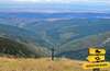
Santa Cruz del Valle Urbión, Burgos![]()
![]()
![]()
![]()
![]() (1)
(1)
One of the paradises of the Mountain Range of La Demanda
![]() Difficulty-Moderate
Difficulty-Moderate
![]() 2:50 h.
2:50 h.
![]() 7 km.
7 km.
Santa Cruz del Valle Urbión, Burgos![]()
![]()
![]()
![]()
![]() (1)
(1)
One of the paradises of the Mountain Range of La Demanda
![]() Difficulty-Moderate
Difficulty-Moderate
![]() 2:50 h.
2:50 h.
![]() 7 km.
7 km.
Not far from the village of Santa Cruz del Valle Urbión, in the heart of Mountain Range of La Demanda of Burgos, under the watchful eye of the Peak San Millán, the roof of the province of Burgos, the Path of the Waterfalls of Altuzarra us awaits. A hiking route that takes us to visit spectacular waterfalls inside a leafy beech forest.

This circular route of only 7 km starts from the Zarcia shelter, not far from the cozy recreational area of Zarcia. Sharing the route that ascends to San Millán Peak by the Urbión River, we advance in search of the path that will take us inside the deep ravine through which the Altuzarra stream flows. Not before taking us to visit the Majada of the Goats, a place that precedes the real beginning of the Altuzarra Waterfalls Path. The Small Jump, the Middle Jump and the Double Jump are the three spectacular waterfalls that lead us to discover this route.

An itinerary that goes up the course of the Altuzarra stream, wrapped between small waterfalls and magnificent beech trees. The chaotic route takes us from one side of the stream to the other and after visiting the waterfalls it makes us ascend to Majada of Garrula, where we will join the route that comes from the San Millán Peak or El Torruco as it is also known, to descend together in search of the Zarcia shelter from where we start this beautiful route through the Mountain Range of La Demanda.

If you dare to visit the Viewpoint of Domingo Sevilla you have the possibility, from there, to follow the path that leads to the most famous beech tree in Burgos and then return by the Path Enrique del Rivero to the refuge of Zarcia, following the course of the river Urbión, or what is the same route to the Peak San Millán that furrows this river, thus making another alternative circular route.
To get to Santa Cruz del Valle Urbión we can do it either from Belorado, passing through Pradoluengo, or from Ibeas de Juarros passing through Villasur de Herreros among other locations. Also from the vicinity of Barbadillo de Herreros can be accessed through the reservoirs of Arlanzón and Uzquiza. Once in Santa Cruz del Valle Urbión and on the main road, we will find the crossing with the road that goes into the town. Following this road without deviation we will arrive, after a good while and already turned into a dirt road, to the refuge and the recreational area of Zarcia, from where the route starts.
This is a demanding route more than for the distance, because of the technical difficulty and the unevenness of some sections.We will have to take extreme precautions to avoid getting hurt by any stone or hole.
The water on this route shouldn't be a problem, but it's interesting to bring him something to eat so that he recovers his strength. Attention the months of autumn with the hunting hunts that usually there is in the zone.
It is rare that we find cattle along the route and the local fauna is not seen too much either, even so we are in a natural reserve so we will have to contemplate the regulations that govern it.
The parking lot next to the Zarcia shelter (0h 00min), serves as a starting point for this route through La Demanda in Burgos.

We follow the continuation of the road that brought us here, to quickly meet the recreational area of Zarcia.

There our path crosses the bed of the Urbión River to continue with it now to our left.

A little further on we find ourselves in front of the crossroads that marks the separation of the routes that ascend to San Millán Peak. We follow the route on the left that continues close to the course of the Urbión River.

Soon we will see a path on our right and further on the Abanza stream that cuts the course of our path.

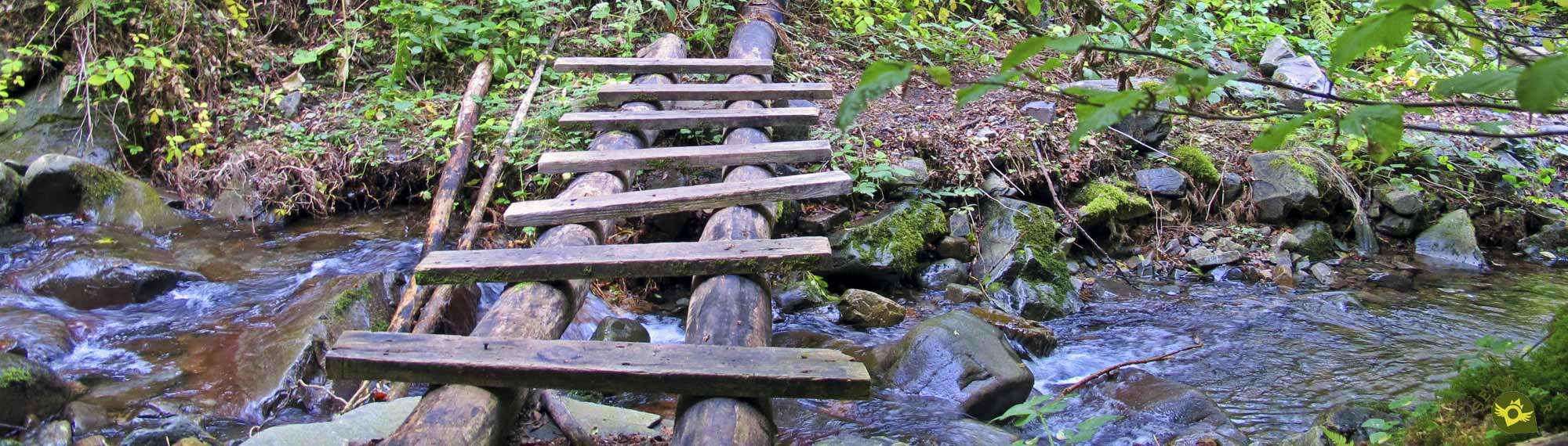
If the riverbed prevents us from passing, we can go up on its course, or follow the previous path, until we find the bridge that allows us to cross it and return to the path.

Once on the path we will meet, almost at the moment, the beginning of the path we must follow, saying goodbye to the path that follows its course to San Millan Peak.

This path begins to gain height quickly as it winds up the mountainside. As we advance, we will find somewhat steep areas, a prelude to the scenario that awaits us further on.

From now on we must be very attentive to the stone landmarks that mark the route in order not to lose the correct itinerary.

After overcoming this first steep path, the path smoothes out its unevenness and introduces us to a leafy pine forest. It is in this forest where the Majada of the Goats awaits us, from where we will begin to lose some of the height gained.

A rocky slope precedes our arrival at the Altuzarra stream, where the real Path of the Waterfalls begins.

As soon as we arrive at the stream we will cross it to start going up its course. A riverbed that can put us in difficulties and make us look for the best way to continue advancing.

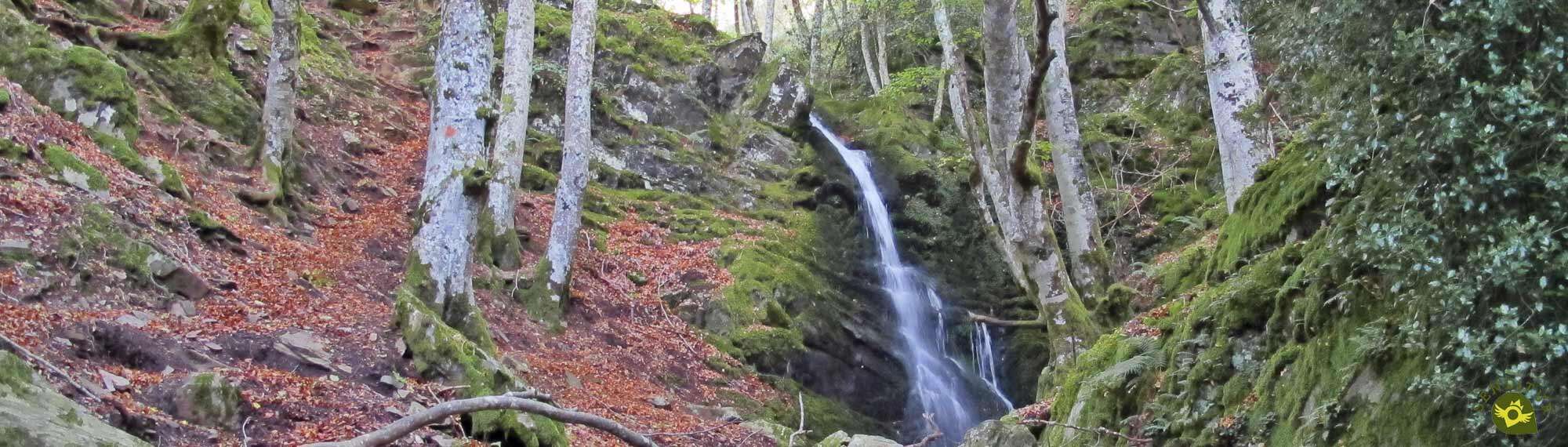
In exchange he gives us splendid corners like the one that hosts the Small Jump, the first of the waterfalls we will visit.

After going up the ledget that has formed the waterfall we will find ourselves looking with relative anxiety for the landmarks that mark the places where, in general, we will have to cross the bed of the Altuzarra stream.

Stream that we will have to cross on numerous occasions. As a general rule we should not get too far from the stream, while following the blurred path that runs through it.

The flow of the stream can notably alter the route and the places where we must cross it, fortunately some red marks, in some trees, join the stone landmarks to help us in the task.

After a while the second waterfall, the Middle Jump, surprises us with its spectacularity. After visiting it, we return to the itinerary ascending the hillside of the mountain, to quickly change direction and face a somewhat exposed step.

From the beginning of the path we are following we see ourselves crossing areas where we must take extreme precautions to avoid falls, and sharpen our sense of direction so as not to follow the wrong path, since the area is quite plagued with stone landmarks that do not mark the right path, or at least the one we should follow.

The Double Jump, the last of the waterfalls on this route, awaits us further on, where we must look for the passage that will allow us to cross the stream again. On the other side we will find the sign that indicates the exit route from this labyrinth of stones and water.

Quickly once again we have to sharpen our eyes so as not to follow the trodden path that goes up into the forest. We will turn off towards the rocky outcrop of the waterfall where we will find the path that we must follow.

This trail winds along the rocky wall making us gain height quickly, without going too far from the creek bed, which we keep listening to.

Once up the creek again marks the course to follow and once again forces us to seek the best area to move forward. A generally well-defined path guides us with the stream to our left.

The detour to the Viewpoint of Domingo Sevilla, which we left behind, marks the near end of this Path of the Altuzarra Waterfalls.

At the moment we arrive next to the sign that now does indicate the path that will take us out of this wild place. A lush pine forest takes center stage as we strive to overcome the considerable slope that separates us from the majada towards which we are heading.

Once again the stone milestones continue to show us the few changes in direction that the path we are walking along draws and that leads us to Alto of Garrula (2h 00min), or the Majada of Garrula as it is also known.
In this majada we will join the route that joins Zarcia with San Millán Peak through Sierra Llana, to start the descent towards the recreational area and the refuge from where we started.

A much more trodden path, than the ones walked so far, is in charge of guiding us in this part of the route.

A stretch that makes us lose height quickly, while we go through the typical curves of the mountain routes.

The pine forest that accompanied us gives way to a beautiful beech forest that gives us all its freshness.

Our path reaches its end when it meets the Abanza stream, which we must cross. As soon as we do so, we will see ourselves following its downward course, with no other reference than the flow of water.

Soon we realize that before we had actually waded through one of the many arms of water that the stream has here, and we keep descending in search of the place where we can actually cross it.

Almost hidden by the vegetation, a battered wooden bridge awaits us through which, now, we will cross the Abanza stream.

Already on the other side, and after descending a few meters a wide path awaits us, which we thank at this point of the route.

This path gradually separates us from the ravine where the stream runs, leading us to our final goal.

A good while later we came across the track that ascends from the nearby Urbión River. A track where we continue to lose height.

Almost without realizing it, we come across the path that we followed at the beginning of our route, the path where we will return to the recreational area and the refuge of Zarcia (2h 50min), where our adventure ends.
 Distance. 7Km
The difficulty of following the route in some areas may cause us to cover more distance than initially expected.
 Time. 2:50h
The spectacular nature of the route, together with the difficulty of following it in some areas and the state of the terrain in which we find them, make this figure more than ever a mere estimate.
 Time of year
Autumn and spring are, without a doubt, the best time to visit this place, because of its colorfulness and the flow of the stream. It is not advisable to do the route if the rain, the thread or the snow are or have been the protagonists the previous days. Be careful with the hunts that in certain periods of the year can be by the zone and that will prevent us the passage.
 Required equipment
Even if it is not a very long itinerary we must equip ourselves correctly. Hiking boots that can withstand water and long pants, the GPS with the corresponding track that serves as a reference are some examples. The hiking poles will be of great help, although at some points they can get in the way a little. Even in the summer we may need some warm clothes, due to the sombre nature of the route. Consult our list of material and equipment for hiking. Read more
 Difficulty. Moderate
Physical
Initially neither the distance nor the unevenness to be overcome should be a problem, but we will cross complicated, exposed and quite uneven areas that will require us to be in good physical condition, among other things. These same stretches can stress us more than we think and this increases the physical demand and therefore the accumulated fatigue.
Severity of the environment
Due to the characteristics of the terrain where the route runs, it is not advisable to do it in the opposite direction to the one described, since it increases the risk and possibilities of having an accident. If the terrain is more slippery than usual due to rain, snow or ice we do not recommend doing the route. In addition to the dangers of crossing the streams, some sections of the trail are exposed to vertical falls and the slope of certain sectors of the path is very slippery even in normal conditions.
Orientation
Although we will see milestones of stones and some marks on the trees, the route does not have a correct signaling, partly because of the difficulty of marking the places where we must cross the stream, which undoubtedly change depending on its course. In addition, these milestones can even make us follow the wrong path, since they also mark other routes that run through the area. As if this were not enough, the lack of a clear path in some areas or the many trails in other sections, do not contribute to facilitate the task of following the route.
 |
 |
 |
 |
 |
| 1-Zarcia Shelter | 0:00h | 1045m | 0Km | 30T 482787 4680934 |
| 2-Small Jump | 0:50h | 1160m | 2.1Km | 30T 482787 4679167 |
| 3-Middle Jump | 1:15h | 1280m | 2.7Km | 30T 482512 4678813 |
| 4-Double Jump | 1:25h | 1330m | 2.9Km | 30T 482432 4678761 |
| 5-Detour to the viewpoint | 1:40h | 1395m | 3.1Km | 30T 482322 4678635 |
| 6-Alto of Garrula | 2:00h | 1510m | 3.5Km | 30T 482223 4679011 |
| 7-Zarcia Shelter | 2:50h | 842m | 7Km | 30T 482787 4680934 |
Coordinates UTM Datum WGS84

 Slope: 1070m
 Slope +: 535m
 Slope -: 535m
 Maximum altitude: 1510m
 Minimum altitude: 1045m

This sketch of the route is not made to scale nor does it contain all the information relating to the area, it is merely indicative

![]()
This schematic with the path is approximate and has been created from the derived cartographic base © Instituto Geográfico Nacional "Cuadrante 239-2 y 239-4 1:25.000".
Senditur has manipulated the tracks to correct the aberrant points that may exist, caused by problems with the reception of the GPS signal. In any case the tracks are always approximate. SENDITUR encourages you to use the new technologies within your reach, using them as support and consultation in your activity, not basing the realization and orientation of the same only and exclusively on them, since they may see their functioning altered by very diverse causes, not functioning correctly and their indications may not be precise.


En otoño sobre todo esta ruta es una maravilla, con el hayedo de Altuzarra y las cascadas como colofón.
Manganese mines whose exploitation is probably one of the oldest in Spain
Great encyclopedia of the evolution of man, natural treasure kept in time

Find out what to see in...
¿Did you know that...
The GR 82 La Demanda Mountain Range passes through Santa Cruz del Valle Urbión. It is a circular path that along its almost 300 km runs through 36 towns in Burgos. It is currently unhomologated but work is underway to restore it to its full splendor.
Don't miss out...
The viewpoint de Domingo Sevilla, whose detour you will find just before embarking on the final climb to the majada of Garrula. This detour of barely 1 km, round trip, brings us closer to a balcony with magnificent views of the Mountain Range of La Demanda in Burgos.


From the commitment of SENDITUR with Nature and the respect to the balance of the environment, SENDITUR urges you to travel in a responsible way, with low environmental impact and respecting at all times the Natural, Cultural and Social environment wherever you go.

Besides sharing with all of us your experience on the route we would be grateful if you could write to us to inform us of any erroneous or outdated information you may have found, or simply to let us know what you think at Thank you.
This route has been carried out in the field by SENDITUR on 8-10-2020. The route may vary greatly depending on the time of year, weather conditions and terrain, as well as the actions of third parties and the evolution suffered in the natural environment where it is located. All opinions, advice and/or assessments made by SENDITUR in their descriptions are for guidance only and are subject to and/or refer to the specific conditions of the specific day of the route, referring to that specific day, taken from trained people, with the appropriate experience and with a high level of physical and technical preparation as a reference, as well as correctly equipped.
All the times are approximate and take an orientative character, the stops have not been taken into account, no matter how small they are. All the information related to the route, texts, images, videos, maps, diagrams, tracks, towns, and places of tourist interest are published as a guide, and may not coincide with the current state of each place. Before undertaking any activity, assess your technical knowledge, your physical condition, find out about the weather and the variations that the route may undergo, equip yourself correctly, be prudent and responsible at all times, and do not exceed your capabilities. SENDITUR is not responsible for any misuse or inappropriate use of the comprehensive guides of its routes and/or publications as well as its electronic guides, nor for any variations in their descriptions for the aforementioned reasons, and recommends that everyone be responsible and prudent in carrying out the activity. We also encourage you to read books and specialised guides to complement the information described above.
Continue watching …


.jpg "Go to Puras de Villafranca Mining Complex")