Welcome to SENDITUR.COM · paths · routes · tourism

![]() Difficulty-Low
Difficulty-Low
![]() 0:50 h.
0:50 h.
![]() 2.9 km.
2.9 km.
![]() Difficulty-Low
Difficulty-Low
![]() 0:50 h.
0:50 h.
![]() 2.9 km.
2.9 km.
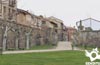
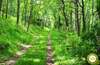
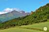
In the valley of the river Cárdenas, in the limits of the Sierra of La Demanda, in San Millán de la Cogolla, cradle of the Castilian, is located the Paths of Suso. Juniper, bonetero and aligustre together with country maple, hazel and wild cherry accompany us on our journey through the forests of pines, oaks and hazelnuts, from which the limestone conglomerate rocks that identify the characteristic silhouette of this land stand out.

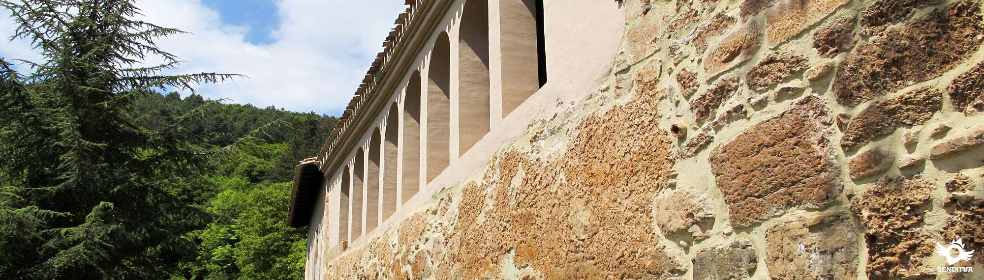
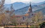
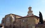
The 2.9 km route not only takes us to walk through the thick forests and unique landscapes that surround the place, but also leads us through them telling us the stories that happened here. From the Renaissance Monastery of Yuso, known as "El Escorial de La Rioja", we walk remembering the steps that the monks who inhabited the place followed to get from one monastery to the other, until the total abandonment of the Monastery of Suso in 1100.

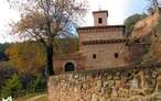
Monastery, the one of Suso, of which it is known already in century VI. Without forgetting the first poet in Spanish language, Gonzalo de Berceo, assiduous reader of the codices and glosses found in the Monastery of Yuso. The path runs through a beautiful landscape offering us a great diversity of colours depending on the time of year, from the yellow, ochre and reddish of autumn, through the almost infinite variety of spring greens to the immaculate white that covers the nearby peaks in winter.

According to legend, because of the saint's appearance at the battle of Simancas in 923, he was named patron saint of Castile. Because of this and because of the attribution of a few more miracles, it is said that King Sancho III ordered the construction of the Monastery of Yuso.
San Millán de la Cogolla can be reached via the LR-331 from Bobadilla or following the LR-205 from the nearby town of Berceo, where the different access roads converge from the A-12 Camino dual carriageway and the N-120 between Logroño and Burgos, well signposted as " Route of the Monasteries". We can arrive by the LR-206 from Azofra or Santo Domingo de la Calzada and from Nájera by the LR-113, which joins it with Salas de los Infantes, taking the detour of the LR-205 that will take us to Berceo and then to San Millán de la Cogolla, which also has an interurban bus service every day. Once there the enclosure of the monastery is located on the other side of the accesses to the town of San Millán de la Cogolla, so we must cross from side to side by its main street or by the road that surrounds it and that we find, as we come from Berceo, a little before reaching the town. This road will lead us directly to the entrance to the Monastery of Yuso, where we will find the information centre and next to it a car park where we can leave our vehicle.
Nice and easy route that takes us along paths and tracks in good condition and with enough space between the bushes on the sides.
Both in San Millán and in the Monastery of Suso we will find water points, although the latter is somewhat hidden in the back of the monastery where we will find a short path that ascends to the fountain.
Livestock area, it is not very common to meet the cattle on this route, if you do is in the final part of our return by the track from Suso.
The route begins next to the parking lot of the Monastery of Yuso (0h 00min) ascending the steep street that took us to him.

At the crossroads of the road leading to Lugar del Río, which leads to the monastery, next to the beginning of the Main Street, is a small park to which we access, climbing a few steps.

The route crosses the park to leave it, crossing the access road to the monastery and continuing along the path that ascends between the cemetery and a watering hole. Almost at the end of this path, our route turns to the left, skirting the limits of a house fence, leaving the path that, if you go straight on, would lead you to the road that goes up towards Suso.

This part of the route narrows little by little, following the row of young trees that mark the course, until it gives way to a slope of earth that we will be forced to climb, to find the path that comes from the road and through which we would have come if we had gone straight ahead.

The path continues its course until shortly after we reach a wooden landmark that indicates the beginning of the trail on our right enters the forest. In this place we can choose if to continue to our right by this trail or to continue the scarce meters to the encounter of the trail that to the left also takes us until the monastery, and by where we will return.

Turn right and head towards the forest to start a short but uncomfortable climb that leads us to join a wide footpath, parallel to the road, going up the Via Crucis from the locality.

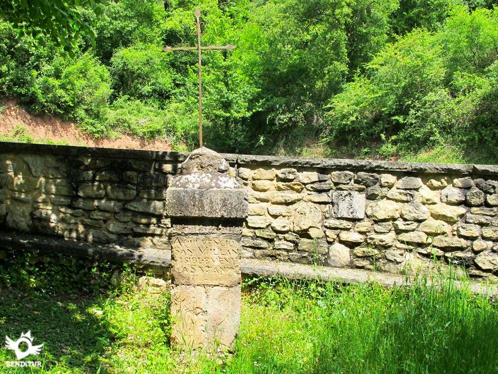
The itinerary takes us to follow the ascent, now more stretched, to arrive until the nearby Monastery of Suso (0h 25min), passing the cruise that marks the beginning of the enclosure.
Once in the monastery and after enjoying this and the privileged place where it is located, the path continues bordering it under its characteristic porticoed atrium, to reach its rear, to find a door that prevents the passage of vehicles and livestock, door that we save by the pedestrian crossing that exists at one end.

As soon as we pass this one, to the left of the wide track we are on, the El Aidillo path begins, a path that goes down quickly towards Yuso and joins the other option of the descent, the Labardera path, where we continue following the track we are on.

This track that runs protected by the leafy forest moves away from the monastery, crossing a firebreak that allows us to contemplate the Monastery of Yuso and the place where we will meet again with the path that we left behind.

After crossing this firebreak, the track takes us a little further on to the place where, in the middle of a curve, we must leave the path to continue along the footpath that descends to our left, going back to San Millán de la Cogolla. This footpath at first with a certain slope leaves the forest at the firebreak, where we find a wooden landmark that marks the beginning of the El Aidillo path, which climbs towards Yuso and that we left behind us to continue along the Labardera path.

The route crosses the firebreak to get back into the forest and descend its final part until we reach the path where to our right, a few meters, we see the detour that at the beginning of our excursion we follow to climb to the monastery.

From here we will only have to retrace our steps to reach the parking lot of Monasterio de Yuso (0h 50min).
 Distance. 2,9Km
The different routes offered by the route make this figure, more than ever, indicative.
 Time. 0:50h
Total time without stops, that if we follow the pat:El Aidillo is shortened in about 10 min, because we save about 600 m of path.
 Time of year
It is in autumn and spring when the route gives us a colorful landscape of ochres and greens respectively. In summer most of the route is protected by the forest that provides its coolness and in winter the proximity of the Sierra of La Demanda and the already good height of the route give spectacular panoramic views.
 Required equipment
Clothing and footwear for sports or hiking according to the time of year and the weather. Recommended photo camera, and lunch. Consult our list of material and equipment for hiking. Read more.
 Difficulty. Low
Physical
It has no physical difficulty, except for a couple of small steeps, the pat:runs comfortably ascending smoothly. If you walk it in the opposite direction to the one proposed, the ascent gets a little longer and its intensity increases a little.
Severity of the environment
Wit:well-defined and well-stable paths, the route runs halfway up the hillside on gentle slopes protected by the leafy forest. Being the dark of the route what in certain points of this one makes persist the humidity and for that reason the mud that can make us difficult the passage in rainy seasons.
Orientation
Generally well signposted, it is at the exit of San Millán on the road that passes the cemetery where it is more difficult to follow the itinerary. Also we should not be confused when interpreting the signs as you are signposted several routes belonging to the Walk of the Saint and that overlap in some areas.
 |
 |
 |
 |
 |
| 1-Monastery of Yuso | 0:00h | 736m | 0Km | 30T 511025 4685979 |
| 2-Monastery of Suso | 0:25h | 850m | 1.1Km | 30T 510489 4686351 |
| 3-Monastery of Yuso | 0:50h | 736m | 2.9Km | 30T 511025 4685979 |
Coordinates UTM Datum WGS84

 Slope: 296m
 Slope +: 148m
 Slope -: 148m
 Maximum altitude: 855m
 Minimum altitude: 736m

This sketc:of the route is not made to scale nor does it contain all the information relating to the area, it is merely indicative.

![]()
This schematic wit:the pat:is approximate and has been created from the derived cartographic base © Instituto Geográfico Nacional "Cuadrante 240-2 1:25.000".
Senditur has manipulated the tracks to correct the aberrant points that may exist, caused by problems wit:the reception of the GPS signal. In any case the tracks are always approximate. SENDITUR encourages you to use the new technologies within your reach, using them as support and consultation in your activity, not basing the realization and orientation of the same only and exclusively on them, since they may see their functioning altered by very diverse causes, not functioning correctly and their indications may not be precise.


Cradle of the Castilian and pantheon of the seven Castilian heroes

Location of the Virgin of Valvanera, Patron Saint of La Rioja

Find out what to see in...
¿Did you know that...
The Monastery of Suso is known as the Pantheon of the Seven Castilian Heroes as it houses the headless bodies of the seven infants of Lara in stone tombs located in the southern portico of the monastery.
Don't miss out...
The nearby Monastery of Santa María del Salvador, in Cañas, also known as the Monastery of Light and belonging to the Route of Monasteries, along with those of Yuso, Suso, Valvanera and Santo Domingo de Silos.


From the commitment of SENDITUR with Nature and the respect to the balance of the environment, SENDITUR urges you to travel in a responsible way, with low environmental impact and respecting at all times the Natural, Cultural and Social environment wherever you go.

Besides sharing with all of us your experience on the route we would be grateful if you could write to us to inform us of any erroneous or outdated information you may have found, or simply to let us know what you think at Thank you.
This route has been carried out in the field by SENDITUR on 02-05-2021. The route may vary greatly depending on the time of year, weather conditions and terrain, as well as the actions of third parties and the evolution suffered in the natural environment where it is located. All opinions, advice and/or assessments made by SENDITUR in their descriptions are for guidance only and are subject to and/or refer to the specific conditions of the specific day of the route, referring to that specific day, taken from trained people, with the appropriate experience and with a high level of physical and technical preparation as a reference, as well as correctly equipped.
All the times are approximate and take an orientative character, the stops have not been taken into account, no matter how small they are. All the information related to the route, texts, images, videos, maps, diagrams, tracks, towns, and places of tourist interest are published as a guide, and may not coincide with the current state of each place. Before undertaking any activity, assess your technical knowledge, your physical condition, find out about the weather and the variations that the route may undergo, equip yourself correctly, be prudent and responsible at all times, and do not exceed your capabilities. SENDITUR is not responsible for any misuse or inappropriate use of the comprehensive guides of its routes and/or publications as well as its electronic guides, nor for any variations in their descriptions for the aforementioned reasons, and recommends that everyone be responsible and prudent in carrying out the activity. We also encourage you to read books and specialised guides to complement the information described above.
Continue watching …


.jpg "Go to Monastery of Suso")