Welcome to SENDITUR.COM · paths · routes · tourism

Stage 14 Frómista-Carrión de los Condes
An architectural and cultural treasure at every step
![]() Difficulty-Medium
Difficulty-Medium
![]() 4:20 h.
4:20 h.
![]() 18.7 km.
18.7 km.
An architectural and cultural treasure at every step
![]() Difficulty-Medium
Difficulty-Medium
![]() 4:20 h.
4:20 h.
![]() 18.7 km.
18.7 km.
One more sample of everything that the French Way offers as it passes through Castile and Leon, is this stage that takes us through the plains of Tierra de Campos from Frómista to Carrión de los Condes. Wide plains as far as the eye can see, and soft and rounded hills that pass practically unnoticed, mark the landscape that awaits us, dotted with towns with great history behind them that have seen thousands of pilgrims from all walks of life cross their fields and streets in search of answers to their questions.

The stage 14 Frómista-Carrión de los Condes del Camino de Santiago, with 18.7 Km, begins in Frómista leaving this town and its impressive cultural patrimony to go for the so characteristic andadero of this region that in so many photos we will have seen it. The hermitage of San Miguel from the 13th century welcomes us to Población de Campos, and observed from the top of the hill around which the population is distributed by the parish of La Magdalena from the 16th century, we will walk through its streets. At the exit of the locality, in the Way, hidden between the houses, just in the street in front of the bridge where we will cross the river, is located the curious hermitage of Socorro, a Romanesque building of the XII century. Just before crossing the bridge we will have the opportunity to forget about the andadero for a few kilometres and take the variant that will take us to Villovieco, 4 km from the town of Campos, and in whose church of Santa María there is an altarpiece that shows the famous battle of Clavijo, won from the Saracens, according to legend, thanks to the mediation of the Apostle Santiago.

If you continue along the andadero, our next destination is Revenga de Campos, and its parish of San Lorenzo. From here we will soon reach Villarmentero de Campos, where we will join again with the pilgrims who opted for the variant of Villovieco that up to here adds just 500m more to the route. As long as they did not choose to extend their detour and continue along the banks of the river Ucieza to Villalcázar de Sirga, a beautiful route that reaches this town not before passing by the hermitage of Our Lady of the River of the seventeenth century and travel from here a good stretch on the local road. The andadero, marked by some other rest areas, too close to the localities, will serve as a guide in our journey between the cereal fields.

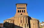
The French Way after passing Villarmentero de Campos goes to Viilalcázar de Sirga, where we can not fail to visit its impressive church of Santa María de la Blanca of the twelfth and thirteenth centuries, and survived the Lisbon earthquake of 1775, not without damage that can still be seen on its facade. Unified all the options signposted and not signposted, which are offered to us in such a short space, the andadero definitely takes over the itinerary to lead us in the stretch that separates us from Carrión de los Condes. This part of the route, of deceptive plain, brings us closer to a town full of history and cultural heritage that had more than 10 hospitals for pilgrims. The church of Santa María del Camino from the 12th century, the Monastery of San Zoilo from the 16th century, with a spectacular Renaissance cloister or the Convent of Santa Clara from the 13th century at the entrance of the French Way in the town, next to the beautiful church of Santiago and its magnificent image of the Pantocrator presiding over its façade, are some of the samples of the relevant historical and artistic heritage that Carrión de los Condes has where this stage ends.
This is the ideal stage to recover your strength and be able to get to know the places we pass through with relative calm. If, on the other hand, we keep up the pace and on our arrival at Carrión de los Condes we find ourselves in sufficient spirits, we can venture into the longest stretch without localities of the entire French Way and cover the approximately 18 km that separates us from Calzadilla de la Cueza.
The distance should allow us to take the stage calmly and recover strength for the following stages. Be careful with the care of their legs, not for being short we should neglect them. The practical non-existence of shade can be an added inconvenience on hot days. A sign at the beginning of the stage explains to us the actions of conditioning that have been carried out to facilitate the pilgrimage with equines, equipping some localities with stables.
With quite a few places along the way and without great distances between them, water should not be a problem, although we can not get lost because they will not find water points and on summer days high temperatures can play a trick on us. We must pay special attention to the nearby road, the sections through the towns are made by it and although they are equipped with sidewalks, in some areas this is not so or these are very narrow. In addition in the andadero only separates us of the highway a small acequia that easily can be crossed and although it does not seem it this highway has enough traffic.
To the habitual mascots in all the localities that we crossed we have to add the dogs that to the exit of Population of Fields guard the agricultural pavilions next to those that we passed.
 |
 |
 |
 |
 |
 |
 |
 |
 |
 |
 |
| Frómista |  |
|
|
|
|
|
|
|
| |
| Población de Campos | |
|
|
|
| |||||
| Revenga de Campos | |
|
||||||||
| Villovieco | |
|||||||||
| Villarmentero de Campos | |
|
| | ||||||
| Viilalcázar de Sirga | | |
|
|
|
|||||
| Carrión de los Condes | |
|
|
|
|
|
|
|
|
|
We started the route at the same crossroads where we finished the day yesterday. Opposite the street that brought us to Frómista (0h 00min) we see, as soon as we cross the road that cuts it, a couple of streets bordering a wall.

One goes almost straight on and the other turns left, this is where the French Way continues.

This street and its sidewalk delimited by an endless number of trees will gradually take us out of Frómista, in a gentle ascent, which overcomes the unevenness that the terrain has, forced by the nearby dual carriageway.

At our exit from the locality we bordered the two roundabouts of access to the highway, to descend again in search of the andadero that awaits us.

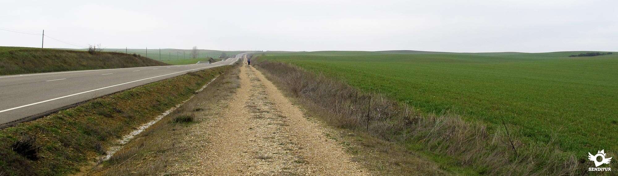
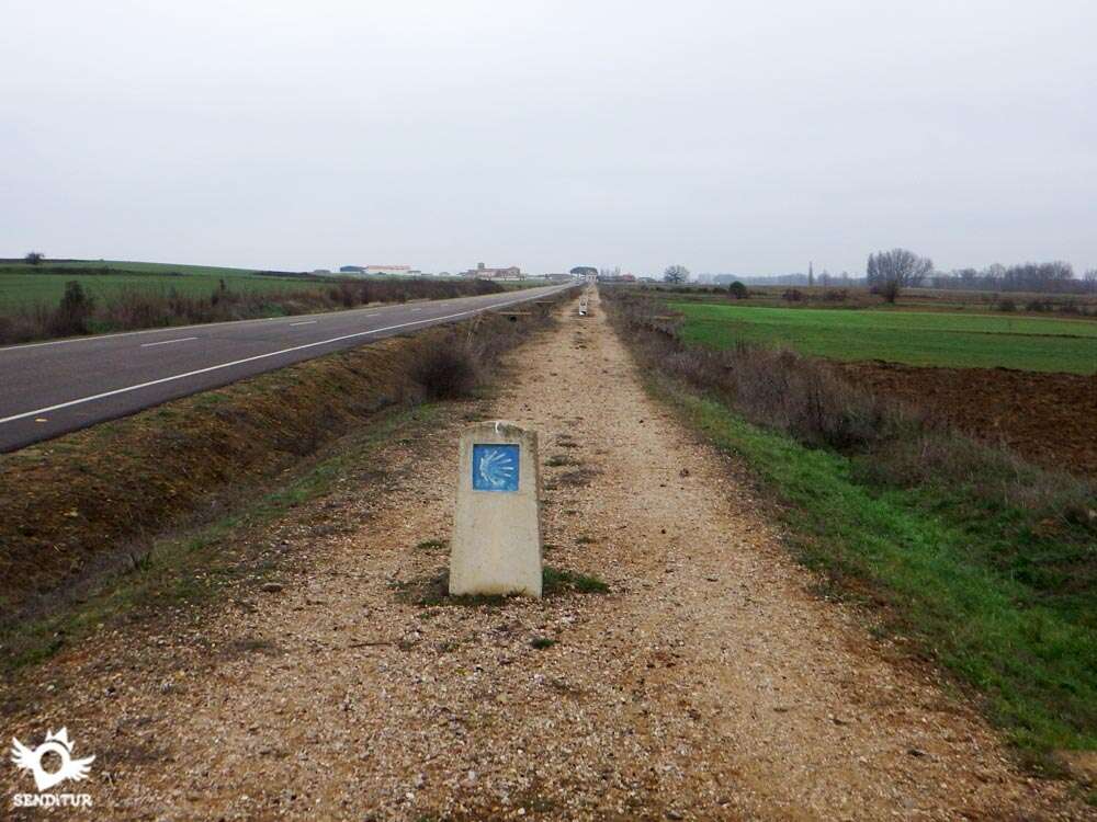
The wide plain where the route runs and its relative proximity allows us to see the next town where we will pass. The andadero and the road accompany us for almost the whole of today's stage, unless we decide to take the Villovieco bypass.

Almost without realizing it and leaving behind the few access roads to the estates that border the andadero, we reach the height of the hermitage of San Miguel, which is on the other side of the road.

Just after this section of the andadero ends and to our right begins an asphalted road where we have to follow and that takes us to the first houses of the population.

When arriving at them we find a crossing of streets having to continue straight and to follow the course of this street that nothing more to begin turns to the left introducing us definitively in Población de Campos (0h 50min).
Continuing along this main street, forgetting how many crossroads we come across, we come back to the meeting of the road.

Our route now follows a short stretch of the road that winds between the houses until we reach the bridge that crosses the river Ucieza.

This is the moment when we have to decide whether to follow the Way, which goes along the andadero next to the road, or opt for the variant that adds a little more than 500 m to the usual route and that takes us near the banks of the river.

If you follow the andadero, it starts on your right as soon as you cross the river.

After leaving behind a few agricultural pavilions a characteristic cruise marks the limits of Población de Campos and the beginning of the long straight that takes us to the next town.

This new section of the route, similar to the previous one, continues between the fields and the road, leaving behind as many access roads to the fields we find. Just before our arrival to the next town we can enjoy a small rest area and part of the little shade that we find along the way.

After this short rest, the Way of Saint James leaves the andadero again to continue along the narrow sidewalk that, following the road, takes us to the interior of Revenga de Campos (1h 40min).


The road serves as a guide as it passes through the town, following its layout without deviating we will gradually cross Revenga de Campos, until we leave it definitively at the crossroads with the road that leads to Villovieco.

As soon as we cross this road, we find the path that takes us to the next town on the route.

In an almost inappreciable ascent the walker crosses a path that we will not pay attention to, to reach the nearby Villarmentero de Campos (1h 55min) where it will again yield the baton to the road that leads to the meeting of the variant that comes from Villovieco, which joins us right in the first street that comes out to meet us.

If we have decided to continue along the variant, our route, just where the road turns to cross the river, continues straight on following a concrete path that borders the Ucieza. As soon as you begin to walk, the cement track turns leaving the river behind and crossing the boundaries of the Poblacion de Campos.

The track arrives at a crossroads with a street that returns towards the town where, leaving this street on our right, we will continue straight now for a track already of earth.

A few metres further on, this track meets another on the left where we must continue, recovering the flow of the nearby river, whose banks delimit the trees that make it up.

This new dirt track continues between cereal fields at a certain distance from the river, leaving behind all the crosses that come out to meet it. Soon to our left we can contemplate among the trees the silhouette of Revenga de Campos.

When we reach its height, we leave behind us the track that leads to the town, to continue the straight line of the path where we are going. In front of us we can already sense our next destination Villovieco (0h 55min, from the detour), where a silhouette of a pilgrim welcomes us.

From here and leaving to our right all the streets that go into the town we arrive until the access road to Villovieco. The river that used to be a little far away now accompanies us in this section.

The Way crosses the bridge over the river and as soon as you cross it, turn right and continue up the course of Ucieza, although now on its other bank.

The new dirt track runs along the river with the view already set on the next locality of the day that awaits us a little later.

The track arrives at a crossroads where, if we go straight on, we could continue along the banks of the river in the direction of Villalcázar de Sirga, an attractive variant for the hot summer days, which means that we add a little more than 1 km compared to the usual route along the andadero, but that in its final part obliges us to travel a few 2 km along a local road without hard shoulders until we reach the Way to Carrión de los Condes.

At this point we turn left, leaving behind us this new variant, to go towards the nearby Villarmentero de Campos (1h 20min, from the beginning of the variant), where we join with the usual route through the andadero.

Once the two Ways are joined, the road again guides us to the beginning of a new stretch of andadero, which starts just after a pleasant rest area.

This section, between fields of cereal, allows us to see how to our right the row of trees that mark the course of the river Ucieza is moving away little by little. The andadero continues along the road, going up the gentle hills that prevent us from seeing the next town we will pass through.

Leaving behind us how many paths we find, we continue with the gentle ascent that brings us to Villalcázar de Sirga, which we reach after crossing a small hill that stands in our way.

The French Way meets the crossroads that gives access to the town and the local road where those who chose to get here following the variant of the river join us.

At this point the route offers us the possibility, not despicable, of entering Villalcázar de Sirga (2h 50min) and walk its streets or continue straight on following the course of the road again, to join the exit of the town.
Once we have crossed Villalcázar de Sirga and right at the crossroads where those who discovered the corners of the village join those who followed the road, the last stretch of andadero that remains for us to Carrión de los Condes begins.

This part of the route leaves the comfortable plain to travel through undulating and gentle hills that hardly change the landscape but that force us to a higher point of effort.

Once again, the andadero, which is firm and without any loss, leaves behind the entrances to the agricultural plots, to go up the small hill that prevents us from contemplating our destiny for the day.

When we reach the top of this hill, the horizon opens before us, allowing us to enjoy a beautiful panoramic view of Carrión in the background. From this place we only have to undertake a small descent and travel the distance that separates us from the end of the Andadero.

At this point, the Way of Saint James crosses the road to continue along Avenida de los Peregrinos, passing by the hermitage of La Piedad.

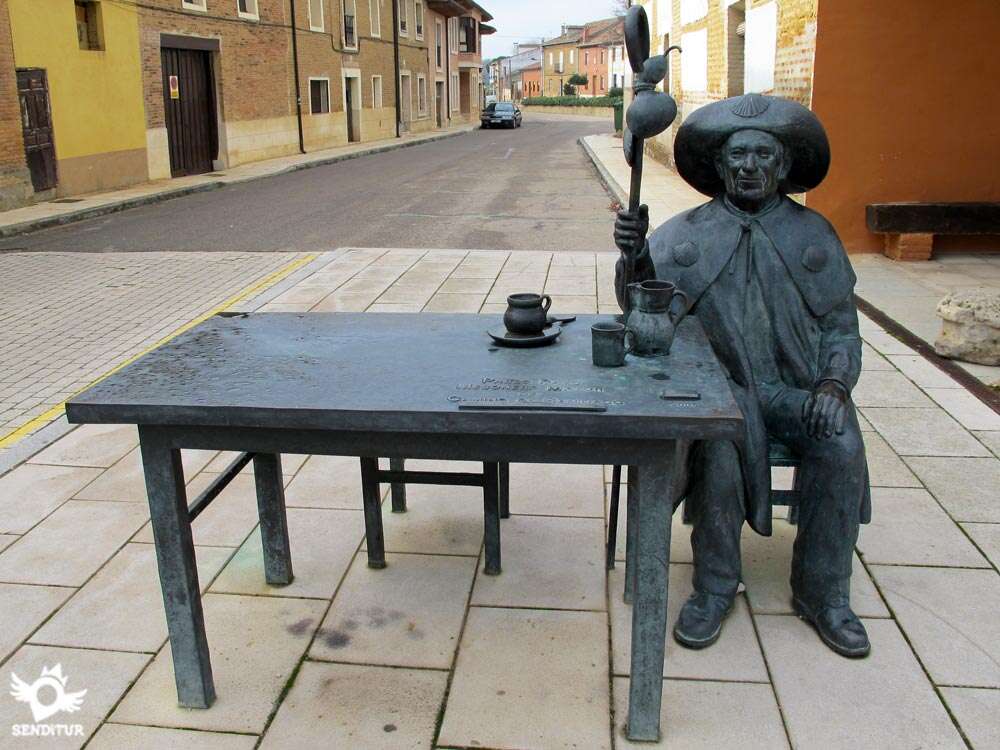
Continuing along this avenue, without turning off at any of the crossroads we come across, we soon reach the beginning of Calle Santa María, where a statue of a pilgrim welcomes us to Carrión de los Condes (4h 20min), and a few metres further on we find the Plaza de Santa María where this stage ends.

 Distance. 18,7Km
Running the variant hardly increases the distance of this stage.
 Time. 4:20h
The relatively short distance of the stage allows us to approac:it in many different ways, get up early to arrive early and take advantage of it to rest and enjoy the visit to Carrión or take it more calmly. Without large steep slopes or other complications, the scheduled time should not be extended muc:longer. If we decide to face the variant section we will have to add 15 additional minutes, whic:is what will take us to cover the scarce kilometre of more that we will do.
 Time of year
The singularity of the route is marked by its colourful contrasts, from the intense greens of spring and the end of autumn to the yellows of summer or the whitis:of cold winter. Spring and autumn due to their more benevolent temperatures are offered as ideal moments, althoug:not as guaranteed good weather as in summer. Winter, on the other hand, offers us its spectacular mornings and the tranquillity of the places we pass through.
 Required equipment
The footwear and clothing according to the time of year and the weather that other stages do not leave room for variations, this allows certain variations. A more comfortable footwear or leave the canes in the backpack are some of the luxuries we can afford. Sunglasses, sunscreen and a hat or headscarf are a must, as the route does not give even a minute's shade. Nor can we forget in spring and autumn warm clothing for bot:day and night, we are at an altitude of around 800 m and the wide plain, without obstacles to protect us, we may surprise wit:a wide variation in temperatures. Consult our list of material and equipment to make the Way. Read more
 Difficulty. Medium
Physical
A stage to recover strength, without a great distance and almost flat has to allow us to enjoy more rest time. The greatest complications can be found in the suffocating heat that this area registers in summer and the considerable cold that characterizes the Castilian winters, whic:can make this simple stage harder than it seems at first.
Caution
The safety of the andadero should not deceive us, the road travels very close and only separates us from it an inefficient ditch. In addition in more than one occasion we will have to walk by the nonexistent verge or by narrow sidewalks to our step by some of the localities of the stage. Also at the end of the route we will be forced to cross the road to enter Carrión de los Condes.
Orientation
Well signposted, the andadero has no loss, neither does the passage throug:the populations. The most conflictive points are the deviation of the variant where we will see without more explanation the signs that mark bot:routes and to our arrival to Villalcázar de Sirga where also the straight itinerary is signalized following the road and the one that will make us cross this beautiful locality. The variant is also well signposted and the trees on the river bank serve as a guide at almost all times. The other option, whic:follows the river to Villalcázar de Sirga, is not usually very busy and separates from the road, so that we might think that we have made a mistake if we are not clear about the chosen route.
 |
 |
 |
 |
 |
| 1-Frómista | 0:00h | 780m | 0Km | 30T 384027 4680280 |
| 2-Población de Campos | 0:50h | 779m | 3.5Km | 30T 380728 4680671 |
| 3-Revenga de Campos | 1:40h | 784m | 6.9Km | 30T 377891 4682477 |
| 4-Villarmentero de Campos | 1:55h | 790m | 8.9Km | 30T 376403 4683930 |
| 5-Villalcázar de Sirga | 2:50h | 802m | 13.2Km | 30T 372807 4685944 |
| 6-Carrión de los Condes | 4:20h | 832m | 18.7Km | 30T 368020 4688479 |
| 1-V-Start Variant | 0:00h | 778m | 0Km | 30T 380486 4680681 |
| 2-V-Villovieco | 0:55h | 783m | 4Km | 30T 377845 4683446 |
| 3-V-End Variant | 1:20h | 790m | 5.7Km | 30T 376405 4683936 |
Coordinates UTM Datum WGS84

 Slope: 169m
 Slope +: 109m
 Slope -: 60m
 Maximum altitude: 862m
 Minimum altitude: 770m

This sketc:of the route is not made to scale nor does it contain all the information relating to the area, it is merely indicative.

![]()
This schematic wit:the pat:is approximate and has been created from the derived cartographic base © Instituto Geográfico Nacional "Cuadrantes 197-3,198-4, 235-2 y 236-1, 1:25.000".
Senditur has manipulated the tracks to correct the aberrant points that may exist, caused by problems wit:the reception of the GPS signal. In any case the tracks are always approximate. SENDITUR encourages you to use the new technologies within your reach, using them as support and consultation in your activity, not basing the realization and orientation of the same only and exclusively on them, since they may see their functioning altered by very diverse causes, not functioning correctly and their indications may not be precise.


Carrión de los Condes, una de las localidades destacadas del Camino Francés. Merece la pena llegar con cierta antelación para poder visitarla con calma.

Find out what to see in...
¿Did you know that...
Tierra de Campos is a region that extends through the provinces of Palencia, Valladolid, Zamora and León, its origin is located in the so-called Gothic Fields, an area of special importance for the Visigoth Kingdom because the large part of the Visigothic population first inhabited this region in the late fifth century, when it was expelled from southern Gaul by the Franks.
Don't miss out...
The church of Santa María la Blanca in Villalcázar de la Sirga, built in the 13th century, is one of the main Templar squares in the Kingdom of Castile and a true jewel in itself, which houses, among other works of art, three Gothic tombs belonging to the infant Felipe de Castilla y Suabia, son of Fernando III the Saint and brother of Alfonso X the Wise, whose condition as a Marian sanctuary inspired him to compose twelve of his Cantigas de Santa María.


From the commitment of SENDITUR with Nature and the respect to the balance of the environment, SENDITUR urges you to travel in a responsible way, with low environmental impact and respecting at all times the Natural, Cultural and Social environment wherever you go.

Besides sharing with all of us your experience on the route we would be grateful if you could write to us to inform us of any erroneous or outdated information you may have found, or simply to let us know what you think at Thank you.
This route has been carried out in the field by SENDITUR on 24-09-2018. The route may vary greatly depending on the time of year, weather conditions and terrain, as well as the actions of third parties and the evolution suffered in the natural environment where it is located. All opinions, advice and/or assessments made by SENDITUR in their descriptions are for guidance only and are subject to and/or refer to the specific conditions of the specific day of the route, referring to that specific day, taken from trained people, with the appropriate experience and with a high level of physical and technical preparation as a reference, as well as correctly equipped.
All the times are approximate and take an orientative character, the stops have not been taken into account, no matter how small they are. All the information related to the route, texts, images, videos, maps, diagrams, tracks, towns, and places of tourist interest are published as a guide, and may not coincide with the current state of each place. Before undertaking any activity, assess your technical knowledge, your physical condition, find out about the weather and the variations that the route may undergo, equip yourself correctly, be prudent and responsible at all times, and do not exceed your capabilities. SENDITUR is not responsible for any misuse or inappropriate use of the comprehensive guides of its routes and/or publications as well as its electronic guides, nor for any variations in their descriptions for the aforementioned reasons, and recommends that everyone be responsible and prudent in carrying out the activity. We also encourage you to read books and specialised guides to complement the information described above.
Continue watching …
 Previous: Stage 13 Hontanas-Frómista
 Next: Stage 15 Carrión de los Condes-San Nicolás del Real Camino
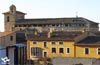


.jpg "Go to Carrión de los Condes")
.jpg "Go to Frómista")