Welcome to SENDITUR.COM · paths · routes · tourism

![]() Difficulty-Medium
Difficulty-Medium
![]() 3:15 h.
3:15 h.
![]() 8.7 km.
8.7 km.
![]() Difficulty-Medium
Difficulty-Medium
![]() 3:15 h.
3:15 h.
![]() 8.7 km.
8.7 km.
The Aizkorri-Aratz Natural Park hides magical corners of great beauty, one of these most remarkable places is undoubtedly the eye of Aitzulo. The municipality of Araotz, not far from the monumental town of Oñati, has many hiking trails such as the The Water Way or PR-GI 3003 that leads us to visit this impressive cave.

The official route has 8,4 km, inviting us to make several detours that increase the beauty of the route and hardly increase the final mileage. The monumental set that forms the old bowling alley and the parish of San Miguel de Araotz is a magnificent departure point for this route that in a first moment will take us to cross the different villages that populate the zone. We will ascend to the Zeliaundi pass, where a short detour will take us to the Santa Cruz de Ugastegi hermitage, a good place to enjoy a well-deserved rest while contemplating the surrounding landscape. From there we will resume our journey, in our case deviating for a while from the PR-GI 3003 to climb to the summit of the Orkatzategi.

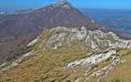
The views from this Basque mountain are unbeatable, on one side the Anboto and the Urkulu reservoir and on the other the Zaraia mountain range, the Arantzazu sanctuary and the highest peaks in Gipuzkoa. We leave this summit to descend in search of the Water Way while we continue to pass by the various tumuli that populate this area. Together we arrive at the true protagonist of this route, the eye of Aitzulo, a grandiose cave open to the cliff where it sits and invites us to enjoy it calmly. From here we only have to follow the path that will take us back to the farmhouses that will accompany us to our starting point.

There are several routes and trails of different levels that allow us to reach the eye of Aitzulo, although one of the most followed is the one described here.Some of these start from the parking lot of the Arrikrutz caves from where we can also begin this route, in the opposite direction to the one described, but extending the total distance of the route by 3,4 km.
To get to Araotz we have to go to Oñati through the GI-2630 road that connects it with Legazpi and the AP-1. From Oñati we must follow the road that ascends to the Sanctuary of Arantzazu, in it we will find the detour that leads to Araotz. Along this road we will have several areas where we can park our vehicle. You must be careful because many of them belong to the hamlets and you cannot park in them.
Simple tour for our friend, as long as he is used to the routes in the mountains. We can not forget that we are in a natural park so we must observe the rules that govern it.
Although there are some places where you can drink it is better to bring enough water and some food.
We are in a livestock area par excellence and although usually the cattle are in closed plots, it is not uncommon to find them on the road.
The Parish of San Miguel de Araotz (0h 00min), marks our starting point for this trekking route through the Natural Park of Aizkorri-Aratz.

The route continues up the road that brought us here.

We are gaining height as we leave behind the different hamlets that come our way, as well as some the paths.

Almost without realizing it, we arrive at the detour we must follow, saying goodbye to the highway that accompanied us until here.

The slope gives us a little break allowing us to enjoy the views that this beautiful walk offers. We follow the white and yellow marks of the PR-GI 3003 at all times, while crossing several doors for the cattle.

After a while our path reaches its end when it meets the asphalt track that ascends from the road that took us to Araotz.

This paved road will take us to the Zeliaundi pass, overcoming the unevenness that still separates us from it. Converted its asphalt into a rough cement, our road continues to make us keep the effort to move forward.

After a while, in front of us, we can already see the silhouette of the Santa Cruz de Ugastegi hermitage, which awaits us at the top of the hill we are climbing.

Once in the Zeliaundi pass (1h 15min) the Water Way that we are following turns right to follow a narrow path. In our case we cannot resist visiting the Santa Cruz de Ugastegi hermitage located just 225 m from the crossroads where we are.

Enjoying the magnificent landscape that can be seen from the chapel, we return to the crossroads of the hill. There, instead of following the paved path of the PR-GI 3003, we continue along the wide path that runs parallel to it.

Our intention is to climb to the summit of Orkatzategi, which we can already see in front of us, saying goodbye for a while to the Water Way, the route of which runs halfway up the hillside to the opposite slope where we meet, where we will join it again.

This detour again demands a new effort to gain height with every step, leaving behind some crossroads.

As soon as we reach a new hill, just before starting the descent we see in front of us, we leave the path that brought us here to go to the summit we want to conquer.

This stretch has no marks or signs to help us along the route and the path we must follow is barely noticeable under the grass that covers it.

Although, if the fog does not impede it, the Orkatzategi serves us as a reference in the few crossings that we will find.

The final stretch of the ascent leaves us almost at the mercy of our sense of direction to find the summit of this mountain.

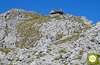
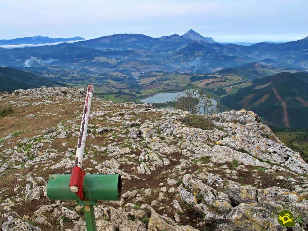
The typical mailbox that crowns the summit of the Orkatzategi (2h 00min) receives us in this impressive viewpoint that we have ascended.

Once we have made a well-deserved stop, we begin the descent that will take us to the eye of Aitzulo.

In this case the path to follow is a little more marked than the ascent, making us travel the other side of the triangle that draws the route we are following and whose base is the path that follows the PR-GI 3003.

As before, we must be careful not to lose the path we must follow. This part of the route is a little more abrupt than the route we have taken so far.

After a while we can already see the water raft of the Aitzgain Canal, where we will meet the Water Way.

We continue in search of our old companion of route leaving to a side the raft of water and passing next to another of the innumerable tumuli that we can find in these lands.

The green fields we cross hardly let us intuit the path we should follow. A little further on, the white and yellow marks of the PR-GI help us again in the task of staying on the right track.

We continue to lose height without anything making us feel the presence of the wonderful corner we are heading for.

After a long stretch of descent, the marks on the path warn us of the detour we should take. This path goes into the vegetation radically changing the landscape around us.

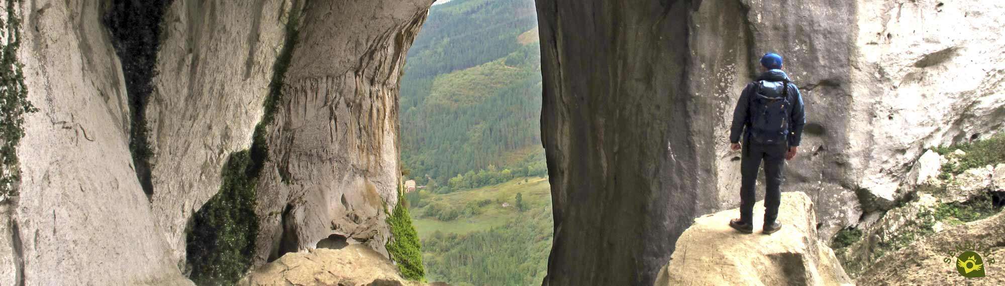
A path that leaves us at the doors of the eye of Aitzulo (2h 35min), which we enter through a stone arch.
Without a doubt we are before an authentic cathedral of nature, whose main altar opens to the void while we observe it absorbed.

Enjoying this spectacular corner of Euskadi, we return to the top of the cave to, on our left, take the path that will take us to Araotz.

Little by little and following the white and yellow marks, we are leaving this abrupt area of the mountain.

Again we see ourselves losing height with every step as we follow a wide path. The descent is as remarkable or more so than the ascent we made at the beginning of the route to reach the Zeliaundi hill.

We continue to lose height and leave behind us as many junctions as we can find.

After passing through a cattle gate we arrive at a curious spot that precedes the farmhouses we are about to visit.

Once again the asphalt is the protagonist of the itinerary, as we go through the different hamlets that populate the area.

The white and yellow marks of the Water Way continue to make our task easier at the junctions we pass through.

After a while the vertiginous descent comes to an end when we come across the main road, which we will continue on. Ahead of us we have a long stretch of asphalt, in continuous ascent, which brings us little by little to the end of this trekking route.

A road that we must leave when we reach the intersection with the paved road that goes up to the Zeliaundi pass, to continue along a concrete path that goes up to Araotz.

A path that forces us to a considerable effort to overcome the unevenness that separates us from the detour we must take. A detour that does not at all loosen the slope that we are overcoming, but that leaves us at the doors of the parish of San Miguel de Araotz (3h 15min).

Place, in this case, from where we start the route and where we will put an end to this beautiful journey through the Natural Park of Aizkorri-Aratz.
 Distance. 8.7Km
If we do not follow the detour that goes up to the summit of the Orkatzategi we would leave the total distance reduced to 8.4 km. while if we dare to visit the chapel of Santa Cruz de Ugastegi we will have to add the 450 m that this detour involves.
 Time. 3:15h
If we follow the official route in its entirety, the figure will drop to 2h 50min. How we face the strong slopes that we have to overcome will mark the final time we will use.
 Time of year
The landscape that surrounds us in most of the route is spectacular, so being able to enjoy it increases the value of this route. The autumn and spring always offer us their striking colors expanding the beauty of the route.
 Required equipment
The route itself is a simple trekking route where water and some food cannot be missing. Some warm clothes or clothes that protect us from the wind are not superfluous even though it is summer. If you are going to climb the Orkatzategi you can't be missing the GPS with the track as it is easy to get lost. Hiking poles will be a great help on the steep slopes to overcome. Consult our list of material and equipment for hiking. Read more
 Difficulty. Medium
Physical
The steep slopes are what mark the difficulty of this route, forcing us to be in good physical shape. With due calm these ramps should not put us in great difficulty.
Severity of the environment
Except for the eye of Aitzulo and the summit of the Orkatzategi, we should not have any major problems. In these two places we should be extremely careful because of the steepness of some areas and the vertical cut we have in both places. The mud can put a degree of difficulty both in the cave and in some areas of the route. Attention in the paved areas, there is usually more traffic than we think.
Orientation
Marked by white and yellow marks at all times, except on the detour to the Orkatzategi where there are no marks to guide us. The fog can make it quite difficult to get your bearings, especially on the unmarked stretch.
 |
 |
 |
 |
 |
| 1-Araotz | 0:00h | 462m | 0Km | 30T 544360 4760030 |
| 2-Pass of Zeliaundi | 1:15h | 735m | 2,5Km | 30T 543218 4760772 |
| 3-Orkatzategi | 2:00h | 869m | 4,6Km | 30T 544321 4762227 |
| 4-eye of Aitzulo | 2:35h | 618m | 6,5Km | 30T 545512 4761217 |
| 5-Araotz | 3:15h | 462m | 8,7Km | 30T 544360 4760030 |
Coordinates UTM Datum WGS84

 Slope: 1050m
 Slope +: 525m
 Slope -: 525m
 Maximum altitude: 869m
 Minimum altitude: 395m

This sketch of the route is not made to scale nor does it contain all the information relating to the area, it is merely indicative.

![]()
This schematic with the path is approximate and has been created from the derived cartographic base © Instituto Geográfico Nacional "Cuadrante 88-3 y 113-1, 25.000"
Senditur has manipulated the tracks to correct the aberrant points that may exist, caused by problems with the reception of the GPS signal. In any case the tracks are always approximate. SENDITUR encourages you to use the new technologies within your reach, using them as support and consultation in your activity, not basing the realization and orientation of the same only and exclusively on them, since they may see their functioning altered by very diverse causes, not functioning correctly and their indications may not be precise.


Un sitio espectacular merece la pena visitarlo, aunque las cuestas para llegar no lo ponen fácil. ;-)
Where the highest peaks of the Basque Country can be found

Find out what to see in...
¿Did you know that...
It is believed that Araotz is where the conquistador Lope de Aguirre was born, although there is no historical certainty about it. On the contrary, the route does take us past the birthplace of Marshal Elorza, a hamlet where, according to some voices, Lope de Aguirre was actually born.
Don't miss out...
The cave of Sandaili, inside which is the hermitage of St. Elias, a magical place full of legends and great beauty. You will find the path that leads to it on the access road, at the height of the small Araotz reservoir.


From the commitment of SENDITUR with Nature and the respect to the balance of the environment, SENDITUR urges you to travel in a responsible way, with low environmental impact and respecting at all times the Natural, Cultural and Social environment wherever you go.

Besides sharing with all of us your experience on the route we would be grateful if you could write to us to inform us of any erroneous or outdated information you may have found, or simply to let us know what you think at Thank you.
This route has been carried out in the field by SENDITUR on 10-09-2020. The route may vary greatly depending on the time of year, weather conditions and terrain, as well as the actions of third parties and the evolution suffered in the natural environment where it is located. All opinions, advice and/or assessments made by SENDITUR in their descriptions are for guidance only and are subject to and/or refer to the specific conditions of the specific day of the route, referring to that specific day, taken from trained people, with the appropriate experience and with a high level of physical and technical preparation as a reference, as well as correctly equipped.
All the times are approximate and take an orientative character, the stops have not been taken into account, no matter how small they are. All the information related to the route, texts, images, videos, maps, diagrams, tracks, towns, and places of tourist interest are published as a guide, and may not coincide with the current state of each place. Before undertaking any activity, assess your technical knowledge, your physical condition, find out about the weather and the variations that the route may undergo, equip yourself correctly, be prudent and responsible at all times, and do not exceed your capabilities. SENDITUR is not responsible for any misuse or inappropriate use of the comprehensive guides of its routes and/or publications as well as its electronic guides, nor for any variations in their descriptions for the aforementioned reasons, and recommends that everyone be responsible and prudent in carrying out the activity. We also encourage you to read books and specialised guides to complement the information described above.
Continue watching …


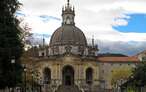
.jpg "Go to Sanctuary of Our Lady of Arantzazu")
.jpg "Go to Aizkorri-Aratz Natural Park")