Welcome to SENDITUR.COM · paths · routes · tourism
The Fageda d'en Jordà, the Santa Margarida Volcano and the Croscat Volcano
![]() Difficulty-Medium
Difficulty-Medium
![]() 4:30 h.
4:30 h.
![]() 12.7 km.
12.7 km.
![]() Difficulty-Medium
Difficulty-Medium
![]() 4:30 h.
4:30 h.
![]() 12.7 km.
12.7 km.
The Garrotxa Volcanic Zone Natural Park, in the province of Girona, is a clear example of the volcanic activity that took place on the peninsula thousands of years ago. This area is home to a large number of volcanoes and is one of the best places in Girona for hiking. There are several perfectly signposted itineraries that can be followed, but perhaps one of the most popular is the circular route of the Fageda d'en Jordà, the Santa Margarida Volcano and the Croscat Volcano, classified as itinerary 1 of the park. This route takes us to visit the spectacular Jordà beech forest, which has grown on the lava flow created by the last eruption of Croscat, the youngest of all the volcanoes in this area. This peculiar beech forest grows on a practically flat terrain and at an altitude of just over 500 m, which is unusual for this type of forest. The route also allows us to enter the dormant crater of Santa Margarida where the old hermitage that is located here awaits us, without forgetting, of course, Croscat.
To get to the starting point of this route and of most of the routes in the Garrotxa Volcanic Zone Natural Park, head for the town of Olot and from there follow the road that links it to Can Blanc and Santa Pau. Just 5 km from Olot, just after crossing Can Blanc, you will find the Can Serra parking area, where you can park your vehicle. This parking is not free, you will have to pay according to the time you leave your vehicle there. There are other areas where you can park without paying, but they are more remote and usually fill up quickly.
In the Can Serra parking area you will also find one of the park's visitor centres and, as we have already mentioned, this car park is also the starting point for many of the possible routes. In our case, we are going to follow itinerary 1, a circular route that we can follow in both directions. If we first head towards the Fageda d'en Jordà we will coincide with the route of itinerary 2 or the Joan Maragall Path, a simple route that allows those who do not want to do the whole route to visit the beech forest.
Next to the information centre, an underpass awaits us, allowing us to cross the road we arrived on.
We soon find ourselves walking along a conditioned path that takes us into the leafy beech forest. In general, leaf litter covers the entire path, but the markings and signs of the route accompany us at all times. The beech forest envelops us with its colourful atmosphere full of legends such as those that surely inspired Joan Maragall's poem. Almost without noticing we reach a small hill in the forest, here those who only want to visit the beech forest will go around it to return to the parking area and complete an interesting route of a kilometre and a half. The rest of us will have to continue onwards following the markings of itinerary 1.
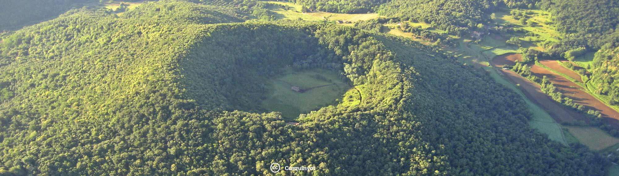
Santa Margarida Volcano-CC/Carquinyol
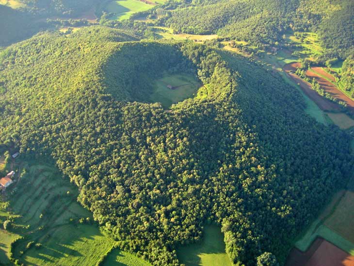
Croscat Volcano-CC/Mikipons
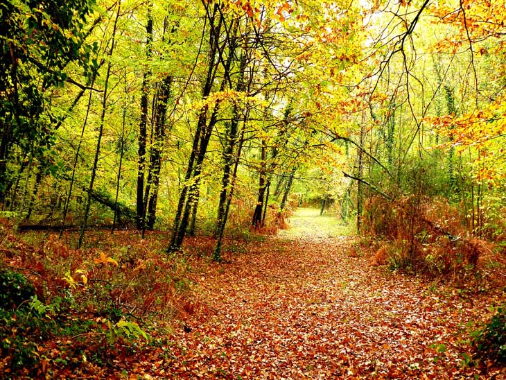
Fageda d'en Jordà-CC/Juan Manuel Gienini

We continue our route through the forest without turning off at the few crossroads we come across, all of which are well signposted. The forest seems to come to an end near the the Fageda cooperative, famous for its dairy products, typical of the area. The itinerary takes you around the cooperative to head towards the start of a demanding uphill stretch that begins next to a beautiful farmhouse. This somewhat more abrupt stretch leads us to the end of the ascent to the church of Sant Miguel Sacot. After enjoying this unique spot, we begin the descent. Ahead of us we can already sense the next steep slope that we will have to climb to reach our next objective. Fortunately, we have already left the more abrupt area behind us and the ascent follows a path with no more complications than those presented by the difference in altitude. Once at the top, the vegetation almost allows us to intuit the crater we are bordering. We can descend to the crater by following the path that takes us to its base where the Santa Margarida hermitage awaits us, located in the centre of the Margarida volcano (2h 40min) 5.9 km from the parking area.
After enjoying this unique natural spot, we return to the route by ascending the path opposite to the slope we came down. Once at the top, we return to the path we left to visit the hermitage and the crater to begin the steep descent ahead of us. The descent takes us past another typical farmhouse, while we follow the route markers that guide us at the different crossroads we pass. Once at the bottom, the free parking area of the Margarida volcano awaits us, another possible starting point for this and other routes in the area.
From this parking area we could return directly to our starting point, but we would miss the highly recommended visit to the Croscat volcano.
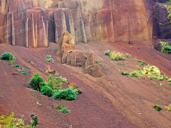
To do so, follow the lane parallel to the road that leads to Olot, to quickly leave it behind and head towards the unmistakable silhouette of the volcano. You should know that to visit the Grederas del volcano del Croscat you have to follow itinerary 15, a route that must be done by prior reservation and accompanied by the park's guides, at least in the most sensitive area of the volcano. The route takes us past the Croscat Volcano information hut (3h 25min), and then back to the track we left to approach the slopes of the volcano. This perfect track will lead you to the parking of Can Serra (4h 30min), from where you start the route, without any further setbacks, apart from the occasional crossroads with their corresponding signs.
1-Initially, the route is not very complicated, although there are some sections that can be a little slippery and where caution should be taken to avoid slipping.
2-This area receives many visitors, so it is advisable to get up early to avoid parking problems and crowds along the route.
3-Don't underestimate the route, equip yourself properly and carry enough food and water.
4-Although the beech forest is spectacular in autumn, this is a route that has great attractions all year round.
 |
 |
 |
 |
 |
| 1-Parking of Can Serra | 0:00h | 570m | 0Km | 31T 460180 4666970 |
| 2-Fageda d'en Jordà | 0:15h | 565m | 0,6Km | 31T 459906 4666669 |
| 3-Volcano of Santa Margarida | 2:40h | 690m | 5,9Km | 31T 462133 4665602 |
| 4-Parking of Santa Margarida | 3:05h | 625m | 7Km | 31T 462320 4666279 |
| 5-Volcano of Croscat | 3:25h | 625m | 8,3Km | 31T 462065 4667169 |
Coordinates UTM Datúm WGS84

.png) Distance: 12,7Km
Distance: 12,7Km
.png) Time: 4:30h
Time: 4:30h
.png) Difficulty: Medium
Difficulty: Medium
 Slope: 640m
 Slope +320m
 Slope -320m
 Maximum altitude: 735m
 Minimum altitude: 555m

![]()
This schematic with the path is approximate and has been created from the derived cartographic base © Instituto Geográfico Nacional "Cuadrante 295-1-2 1:25.000".

¿Did you know that...
The cone of the Croscat volcano, at 160 m high, is the largest on the entire peninsula. Over the years, volcanic material was extracted from its slopes, leaving an impressive gap or gredales.
Don't miss out...
A visit to the towns in the area, from Olot to Santa Pau, offers the visitor countless attractions. In addition to its architecture, its monuments and museums make it highly recommendable to spend some time strolling through its streets.


From the commitment of SENDITUR with Nature and the respect to the balance of the environment, SENDITUR urges you to travel in a responsible way, with low environmental impact and respecting at all times the Natural, Cultural and Social environment wherever you go.

Besides sharing with all of us your experience on the route we would be grateful if you could write to us to inform us of any erroneous or outdated information you may have found, or simply to let us know what you think at Thank you.
Route information updated on 02-06-2021. The route may vary greatly depending on the time of year, weather conditions and terrain, as well as the actions of third parties and the evolution suffered in the natural environment where it is located. All opinions, advice and/or assessments made by SENDITUR in their descriptions are for guidance only and are subject to and/or refer to the specific conditions of the specific day of the route, referring to that specific day, taken from trained people, with the appropriate experience and with a high level of physical and technical preparation as a reference, as well as correctly equipped.
All the times are approximate and take an orientative character, the stops have not been taken into account, no matter how small they are. All the information related to the route, texts, images, videos, maps, diagrams, tracks, towns, and places of tourist interest are published as a guide, and may not coincide with the current state of each place. Before undertaking any activity, assess your technical knowledge, your physical condition, find out about the weather and the variations that the route may undergo, equip yourself correctly, be prudent and responsible at all times, and do not exceed your capabilities. SENDITUR is not responsible for any misuse or inappropriate use of the comprehensive guides of its routes and/or publications as well as its electronic guides, nor for any variations in their descriptions for the aforementioned reasons, and recommends that everyone be responsible and prudent in carrying out the activity. We also encourage you to read books and specialised guides to complement the information described above.
Continue watching …


