Welcome to SENDITUR.COM · paths · routes · tourism

Trail The Holm oaks
Pure nature sprinkled with ancient vestiges of history and culture
![]() Difficulty-Moderate
Difficulty-Moderate
![]() 2:30 h.
2:30 h.
![]() 9.4 km.
9.4 km.
Pure nature sprinkled with ancient vestiges of history and culture
![]() Difficulty-Moderate
Difficulty-Moderate
![]() 2:30 h.
2:30 h.
![]() 9.4 km.
9.4 km.
![]()
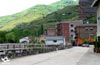
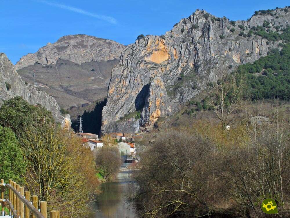
Anguiano, in La Rioja, is the gateway to the High Najerilla Valley, hidden behind the vertical rocks under which this Riojan town sits. Its surroundings, marked by high mountains, leafy forests and abundant streams, are the cradle of unbeatable hiking routes, such as the Trail The Holm oaks, an attractive route marked by the visit to hidden places.

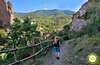
The route takes us, through its 9.4 km, from the heart of Anguiano to the interior of the mountains that surround it, but not before taking us to travel, after crossing the unique Mother of God Bridge, the Caves Neighborhood, one of those that make up the famous town, famous for its traditions and cuisine among other virtues. The path allows us to say goodbye to the town and following the steps of his brothers to approach the vicinity of the Chestnut tree of the Nisia, one of the lords of the mountains of Anguiano. From there, a pleasant walk awaits us, crossing a thick holm oak forest, the sign of identity of the route we are travelling. Soon we will see ourselves saying goodbye to another of the routes that start from Anguiano, and following the marks of the new path that joins the GR 93 with the GR 190, or what is the same Anguiano with its Monastery of Valvanera. The route leads us, under the protection of imposing holm oaks along the tracks and paths that have seen so much activity over the years, to one of the mute witnesses of life in this region, the remodelled Hut of the Estopares.

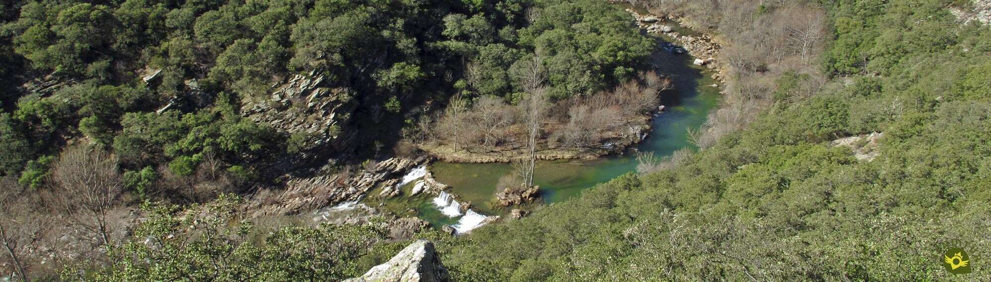
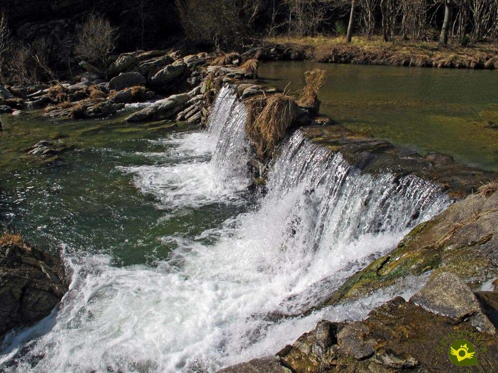
This old corral marks the point of return to Anguiano, which we will do after visiting another of the places that gives this route all its beauty. We will again follow a narrow path that cuts the slope of the mountain while the Najerilla River runs under our feet deepening the valley that has been carving for years. A rapid descent awaits us, which will take us to the very edge of the river, to the Dam of the Benitones. A waterfall that for years has regulated the flow of the river and provided irrigation to the farms that populate its banks. Once we have enjoyed this bend in the river, the path will take us back to the town following the downstream course of the Najerilla River, which seeks to escape from the mountains that imprison it in the sierra. Once again, the Neighborhood of the Caves marks our journey through Anguiano, just before facing the void again and crossing the Bridge of Mother of God in search of the point and end of this Trail The Holm oaks.

The network of trails that surround Anguiano, all of them perfectly signposted, offers those who travel them the possibility of configuring the itinerary that best suits their tastes or characteristics, and this trail is no exception as it coincides with several routes along its itinerary. This gives us the option of shortening or lengthening it in various ways to suit our needs.
The municipality of Anguiano is reached by following the LR-113 that links Nájera with the Burgos town of Salas de los Infantes. This same road, in Nájera, connects with the A-12, Autovía del Camino and with the N-120, between Burgos and Logroño. There is also an extensive schedule of intercity buses that connect Anguiano with both Nájera and Logroño. Once there, in the middle of the road that crosses the town we will find, at the exit of Anguiano towards Monasterio de Valvanera, a parking area where we can leave our vehicle.
Perfect route to accustom him to more demanding routes, by distance and unevenness will be a good layout to see its condition and to make us as much him as we to practice hiking with our dog.
It is important to bring some water and food, although we will find points where you can probably drink without problems. It is not too good idea to let him get into the river, he can carry more strength than we think.
Cattle and bees are the owners and masters of different sections of the route, without forgetting the dogs that, both in Anguiano and in the surroundings, we have to find.
Anguiano (0h 00min) marks the start of this path that begins next to the parking area of the narrow canyon that crosses the Mother of God Bridge towards which we are heading.

We follow, for a few meters, the road that comes from Valvanera until we reach the detour we must take. The imposing Mother of God Bridge allows us to cross the Najerilla River that runs under it.

There are several trails that cross this bridge, as shown by the large number of signs we find on our way.

We follow our course which for now coincides with the beautiful Route of Rocks and the Path of the Chestnut tree of the Nisia, leaving on our left the marks of the link of the GR 93 with the GR 190 Anguiano Valvanera. We go through the neighbourhood of the Caves passing at the foot of the church of San Pedro, leaving behind us as many streets as possible.

Almost at the end of the town, we will say goodbye to the Route of Three Villas, another of those that have accompanied us so far, to get ready to leave Anguiano.

A good stretch of ascent awaits us ahead, which quickly makes us leave the town behind.

Now we see ourselves following a marked footpath regulated by a wooden gate that blocks the passage of the animals.

The unevenness gained allows us to enjoy magnificent views both in front of us and at our back, encouraging us to turn around to contemplate them and catch our breath a little.

Soon we will arrive at the crossroads where we will say goodbye to the Route of Rocks that continues its considerable ascent, to undertake a rapid and short descent in search of the stream that flows under the feet of the Chestnut tree of the Nisia.

After crossing the stream we will arrive at the detour of the Chestnut tree of the Nisia (0h 20min) that leads to this old tree, moment in which our footpath already begins its walking introducing us in a leafy holm oak grove.

We advance, sheltered by the holm oaks, following the path that guides us through the forest, gaining height with each step, but without the demand of the previous ramps.

This section cuts the slope of the mountain that if it were not for the lush vegetation would surely let us see some area of land whose slope would be quite impressive.

The footpath allows us to advance with a certain comfort, protected at all times by the holm oak forest that hardly leaves any clearings where we can contemplate the Najerilla valley that runs under our feet.

After a short while the course of our trail changes abruptly, indicating the proximity of the next junction we have to go through.

After a rapid descent we come across, almost without warning, the cobbled trail that follows the Route of Three Villas (0h 35min) on its way to the Cervanco pass.

We continue with our descent, now with the fleeting company of this trail that also belongs to the Routes between Beeches.

The battered trail ends quickly when it meets a road that will take us to the track where we must continue.

We quickly reach this wide track that comes from the nearby Anguiano, a track where we will say goodbye again to the route with which we coincided, at least until the final stretch of the itinerary.

We continue to go up the course of the Najerilla River, leaving behind for the moment the paths that invite us to get even closer to its, for now, distant course.

Soon we will reach the fork in the road where our route will force us to abandon the track that goes into the ravine of the holm oak.

On the contrary, we lose some height by heading towards the small bridge that will allow us to cross the stream of the Holm oak.

Shortly after crossing this stream we will come to a new junction, the starting point of a new stretch of ascent that we must face by turning right at this point.

After forcing us to make a greater effort than expected, the ramp reaches its end leaving us at the gates of another new crossroads, where we will have the detour to the Hut of the Estopares (1h 00min).

If we continue straight ahead, paying attention to the GR marks that have accompanied us up to here, we will quickly come across the well-tended Hut of the Estopares (1h 05min), a short but interesting detour.
Once we have enjoyed this cozy corner we will have to retrace our steps to the previous junction.

Once there we will follow the path on the right, on the left if we have not continued to Estopares.

At the moment a new path emerges before us making us change our orientation radically as if it wanted to bring us back to the hut we just visited.

But nothing is further from the truth, just a few meters ahead, on our left, the footpath that we must follow emerges.

So we change course again as we continue down the steep slope of the mountain. We are undoubtedly facing the most abrupt section of those we have to pass.

Proof of this are the chains and ropes that, as a small via ferrata, allow us to tackle a short stretch of the steep trail with greater safety.

This area also provides us with wonderful panoramic views of our next destination.

Once this hurdle has been cleared, we will begin a steeper descent than the one we have already undertaken.

The trail winds around trying to make the journey ahead more comfortable.

Even so, we will still find quite steep areas, but also equipped with an invaluable rope as a railing, ideal especially if the area is muddy.

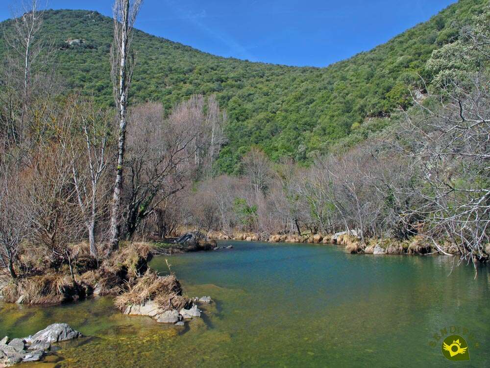
The slope seems to come to an end at the same time as we reach the detour that leads to the Dam of the Benitones (1h 30min).

We followed this short detour in search of the dam that we used to observe from the top of our trail. The trail leads us through the bank of the nearby river, leaving us practically on its shore.

Now we just have to follow its course fitted between it and the ditch that comes from the next Dam of the Benitones (1h 35min).

After the visit to the dam we will have no other option but to return to the crossroads where we turn off to take the trail that we left parked for a moment.

The trail that served as a perfect guide comes to an end, leaving us in the hands of an old road.

It is this road that will lead us through the valley, following in the distance the descending course of the Najerilla.

We will not have greater complications than some stream that at certain times crosses our path in search of pouring its waters into the nearby river.

This area runs along the riverbank, approaching us with every step towards Anguiano and towards the end of our route.

The power station marks our reunion with the itinerary of the track and the Route of Three Villas that we had abandoned a few kilometers ago.

Ahead of us is the part of the route that, following the firm asphalted road that the track enjoys in this area, will take us to the very doors of the town.

When we arrive we will not change our course and we will go directly between the first buildings that receive us.

At the moment the street where we are going gives us a first option to go out to a wide square or to advance a few meters more and go out to it by the next street.

In any case, at the right end of this square begins Valvanera Street, the street where we must continue.

This long street will lead us without detours through the neighbourhood of the Caves leaving us at the beginning of the well-known Mother of God Bridge.

Bridge that we will cross again to go out to the road that crosses the town from Nájera and Valvanera.

Once on the road we only have to cover the distance that separates us from the parking of Anguiano (2h 30min), where we started this Path The Holm oaks.
 Distance. 9.4Km
A route that can be perfectly combined with some of the itineraries it crosses, thus varying its distance.
 Time. 2:30h
The small detours to the hut and the dam are included in the total time, being the time we can entertain ourselves in each place what can influence the total most.
 Time of year
The special uniqueness of the area provides different and abundant attractions throughout the year that justify walking this path, making it a beautiful experience. Perhaps autumn and spring, one for its colourful carpet and the other for the brightness of its days, the liveliness of the streams, the river and in general the nature around us, are the most striking periods of this path. But we must not forget that we walk through a leafy holm oak grove and visit hidden corners or rooted pieces of the history of this land that maintain all its splendour throughout the year.
 Required equipment
The relative simplicity of the route, the proximity of a town or the kilometres we will cover on tracks and roads should not make us fall into the error of underestimating a route. It is essential to wear hiking shoes, preferably boots, especially if you are not very experienced, which will give you a good grip and stability. You should bring enough water and food, warm clothes and a waterproof jacket, a small first aid kit and information about the route that will help you to continue with the route if you have any doubts. Walking sticks can also be helpful, protect us from the sun and do not forget your photo camera, it is not a bad idea either. Consult our list of material and equipment for hiking. Read more.
 Difficulty. Moderated
Physical
As far as the physical demand is concerned, we are facing a route with some demanding slopes that add to the mileage we must do, so it is preferable to be used to this type of activity and have a certain physical shape.
Severity of the environment
To a large extent, we will go along tracks and trails in good condition which, except for some cobbled areas, should not put us in more difficulty. The vegetation is in charge of hiding the slopes that we are cutting when we cross the mountainside. The most exposed area is on the descent to the Benitones dam, coinciding with the most abrupt part of the route. This part of the route has points equipped with sections of chains and ropes that provide us with greater security, as they act as a railing and guardrail. We are not facing technically complicated areas or steps, but they can stress people without experience, besides it is easy to slip on it, even if we have a lot of experience. Of course always in normal conditions, since if we find them with mud, snow or ice its difficulty is considerably extended as well as its exposure, advising against crossing this section under those conditions. It is also important to be aware of the river's flow since the area of the dam can become flooded.
Orientation
Perfectly signposted at all times, it is the great coincidence of signs and different routes that can create some doubt. Doubts that will probably be solved quickly, thanks to the explanatory signs available at the main crossroads.
 |
 |
 |
 |
 |
| 1-Anguiano | 0:00h | 644m | 0Km | 30T 519250 4678582 |
| 2-Detour Chestnut tree of the Nisia | 0:20h | 757m | 1.3Km | 30T 518167 4678959 |
| 3-Link Route of Three Villas | 0:35h | 723m | 2.3Km | 30T 517954 4678083 |
| 4-Detour Hut of the Estopares | 1:00h | 754m | 3.8Km | 30T 517327 4677234 |
| 5-Hut of the Estopares | 1:05h | 760m | 4.3Km | 30T 516952 4677046 |
| 6-Detour Hut of the Estopares | 1:10h | 754m | 4.8Km | 30T 517327 4677234 |
| 7-Detour Dam of the Benitones | 1:30h | 660m | 5.5Km | 30T 517550 4676716 |
| 8-Dam of the Benitones | 1:35h | 655m | 5.9Km | 30T 517366 4676938 |
| 9-Detour Dam of the Benitones | 1:40h | 660m | 6.3Km | 30T 517550 4676716 |
| 10-Anguiano | 2:30h | 644m | 9.4Km | 30T 519250 4678582 |
Coordinates UTM Datum WGS84

 Slope: 756m
 Slope +: 378m
 Slope -: 378m
 Maximum altitude: 765m
 Minimum altitude: 644m

This sketch of the route is not made to scale nor does it contain all the information relating to the area, it is merely indicative.

![]()
This schematic with the path is approximate and has been created from the derived cartographic base © Instituto Geográfico Nacional "Cuadrante 241-1 y 241-3, 1:25.000"
Senditur has manipulated the tracks to correct the aberrant points that may exist, caused by problems with the reception of the GPS signal. In any case the tracks are always approximate. SENDITUR encourages you to use the new technologies within your reach, using them as support and consultation in your activity, not basing the realization and orientation of the same only and exclusively on them, since they may see their functioning altered by very diverse causes, not functioning correctly and their indications may not be precise.


Sendero que pasa por tres joyas de Anguiano...el Castaño de la Nisia, la cabaña de los estopares y la presa de los Melitones. Muy recomendable para familias.

Esta ruta me sorprendió gratamente, es muy entretenida y pasa por sitios bien bonitos.

Location of the Virgin of Valvanera, Patron Saint of La Rioja

Cradle of the Castilian and pantheon of the seven Castilian heroes

¿Did you know that...
The roof of the Hut of the Estopares, today rehabilitated as a shelter, is made of rye straw, just as it was in the past, when the hut was dedicated as a corral for the breeding sheep.
Don't miss out...
The visits to the Dam of the Benitones and the Hut of the Estopares since they are two corners that add to the route even more landscape and cultural value to the one that already has.


.jpg)

From the commitment of SENDITUR with Nature and the respect to the balance of the environment, SENDITUR urges you to travel in a responsible way, with low environmental impact and respecting at all times the Natural, Cultural and Social environment wherever you go.

Besides sharing with all of us your experience on the route we would be grateful if you could write to us to inform us of any erroneous or outdated information you may have found, or simply to let us know what you think at Thank you.
This route has been carried out in the field by SENDITUR on 22-03-2017. The route may vary greatly depending on the time of year, weather conditions and terrain, as well as the actions of third parties and the evolution suffered in the natural environment where it is located. All opinions, advice and/or assessments made by SENDITUR in their descriptions are for guidance only and are subject to and/or refer to the specific conditions of the specific day of the route, referring to that specific day, taken from trained people, with the appropriate experience and with a high level of physical and technical preparation as a reference, as well as correctly equipped.
All the times are approximate and take an orientative character, the stops have not been taken into account, no matter how small they are. All the information related to the route, texts, images, videos, maps, diagrams, tracks, towns, and places of tourist interest are published as a guide, and may not coincide with the current state of each place. Before undertaking any activity, assess your technical knowledge, your physical condition, find out about the weather and the variations that the route may undergo, equip yourself correctly, be prudent and responsible at all times, and do not exceed your capabilities. SENDITUR is not responsible for any misuse or inappropriate use of the comprehensive guides of its routes and/or publications as well as its electronic guides, nor for any variations in their descriptions for the aforementioned reasons, and recommends that everyone be responsible and prudent in carrying out the activity. We also encourage you to read books and specialised guides to complement the information described above.
Continue watching …