Welcome to SENDITUR.COM · paths · routes · tourism

![]() Difficulty-Low
Difficulty-Low
![]() 1:00 h.
1:00 h.
![]() 4 km.
4 km.
![]() Difficulty-Low
Difficulty-Low
![]() 1:00 h.
1:00 h.
![]() 4 km.
4 km.
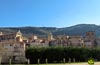
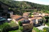
Under the protection of the Montes Obarenes - San Zadornil Natural Park, at the very gates of the rugged La Horadada gorge, the beautiful town of Oña and the Walk of the Oca await us. As a natural border between the Castilian plateau and the Cantabrian area, Oña has been for years the natural pass used to unite both territories.

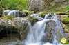
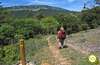
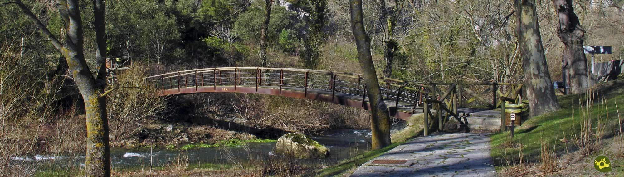
The Walk of the Oca with its 4 Km crosses the imposing gorge of the Horadada, following from the same heart of Oña, the conditioned footpath that furrows it. The Monastery of San Salvador and the historic centre of the town rival in beauty with the natural environment that surrounds them. Verticals cut rocky of more than 200 m imprison the flow of the river Oca as it passes through this narrow gorge. The path advances in good measure parallel to the national one, encountering along its route several bridges by which to cross from one side to the other of the riverbed. The tranquillity of the recreation area of So Castillos invites us to make a stop on the way to enjoy the place we are visiting.

The old railroad track that crossed this pass also has to accompany us in part of the itinerary allowing us to contemplate the vestiges of its past splendor. Later on we will reach the end of the Walk of the Oca, marked by the national one that crosses in our way. Here, before turning around to return to Oña, we will be tempted to continue a few more metres following the signposted route of the GR 1006 and SLC-BU 107 footpaths with which we shared our wanderings. These cross under the national one and, on the other side, surprise us with the last of the bridges crossing the river, undoubtedly the most spectacular of all and worth approaching before returning to Oña, and putting an end to this beautiful excursion.

Legend has it that in one of the tapestries that adorn the walls of the Monastery of San Salvador de Oña you can contemplate the legendary history that is part of the origins of Castile. And this canvas tells the story of how an ancient king, lord of these lands infatuated by a magnificent horse and a bold goshawk owned by Count Fernan Gonzalez agreed with him his transfer for a few days in exchange for a large sum of money. But the infatuated king as he was with both animals wanted to keep them in his power longer, not realizing that the passage of time increased the debt he contracted with the count. This debt became so important that the king had no choice but to cede the County of Castile to the Count with its full independence.
As far as Oña we arrive following the N-232, national road that crosses the locality. Oña is also reached by local roads that connect it with neighbouring villages. Once there, along the national road as it passes through Oña, we will find parking areas where we can park our vehicle. Although the closest to the beginning of the route is located on the other side of the river and the outskirts of Oña Trespaderne direction, next to the old buildings of the train station.
Pleasant walk in which our friend should not have any problem, but we can not get distracted to avoid unnecessary scares.
The water is practically guaranteed to pass through recreation areas where we will find fountains.
Except for the pets with which we can coincide it is not habitual that we run into other animals.
 Distance. 4Km
Our starting point marks the distance to be covered.
 Time. 1:00h
In reality, this is the time we will need if we venture a few metres further on to the imposing bridge that crosses the Oca River at the entrance to the gorge.
 Time of year
Throughout the year the Walk of the Oca is a good colophon to our visit to the locality of Oña. The imposing landscape that surrounds it and the pleasant of the route invite us to make it without haste, with the exception of four counted days in which the bad weather discourages it.
 Required equipment
The state of the route and the short distance to travel allow us to face it as the walk it is, but always taking into account the weather conditions. Consult our list of material and equipment for hiking. Read more.
 Difficulty. Low
Physical
With hardly any distance and an almost negligible gradient, except for a couple of short ramps, this excursion should not be a problem for us.
Severity of the environment
The walk is well conditioned and protected from traffic in areas where we advance next to the national so as long as we do not leave the marked itinerary and apply common sense should not find complications, as long as the terrain conditions are normal good weather. However, we must not forget that we are surrounded by the enormous cliffs of the gorge so we are not exempt from possible rock falls.
Orientation
Embedded by the conditioning of its layout the greatest complications will find them to find their beginning, not having clear in advance where we should go. Likewise, at the end of the Walk of the Oca the doubts will be able to assault us since the marks of the footpaths with which it coincides invite us to continue without any sign warns us of the end of our route.
 |
 |
 |
 |
 |
| 1-Oña | 0:00h | 580m | 0Km | 30T 466183 4731611 |
| 2-End of walk | 0:25h | 573m | 1.8Km | 30T 466397 4733004 |
| 3-Bridge over the Oca River | 0:30h | 570m | 2Km | 30T 466427 4733140 |
| 4-Oña | 1:00h | 580m | 4Km | 30T 466183 4731611 |
Coordinates UTM Datum WGS84

 Slope: 88m
 Slope +: 44m
 Slope -: 44m
 Maximum altitude: 580m
 Minimum altitude: 560m

This sketch of the route is not made to scale nor does it contain all the information relating to the area, it is merely indicative.

![]()
This schematic with the path is approximate and has been created from the derived cartographic base © Instituto Geográfico Nacional "Cuadrante 136-1 y 136-3, 25.000"
Senditur has manipulated the tracks to correct the aberrant points that may exist, caused by problems with the reception of the GPS signal. In any case the tracks are always approximate. SENDITUR encourages you to use the new technologies within your reach, using them as support and consultation in your activity, not basing the realization and orientation of the same only and exclusively on them, since they may see their functioning altered by very diverse causes, not functioning correctly and their indications may not be precise.


Paseo sencillo y sin complicaciones por una zona muy bonita. Oña también merece la pena visitarlo.

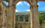

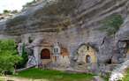
The largest karstic complex in caves on the Peninsula Ibérica
Great encyclopedia of the evolution of man, natural treasure kept in time

¿Did you know that...
From Oña start a good number of hiking routes and mountain trails that run through the Natural Park of Montes Obarenes - San Zadornil. The PR-65 Mesa de Oña or the SL-66 Portillo Amargo are some of the options we have.
Don't miss out...
The visit to Oña is one of the charming towns that make up the province of Burgos. Its streets and monuments will take us back in time and surprise us with their beauty.


From the commitment of SENDITUR with Nature and the respect to the balance of the environment, SENDITUR urges you to travel in a responsible way, with low environmental impact and respecting at all times the Natural, Cultural and Social environment wherever you go.

Besides sharing with all of us your experience on the route we would be grateful if you could write to us to inform us of any erroneous or outdated information you may have found, or simply to let us know what you think at Thank you.
This route has been carried out in the field by SENDITUR on 25-02-2018. The route may vary greatly depending on the time of year, weather conditions and terrain, as well as the actions of third parties and the evolution suffered in the natural environment where it is located. All opinions, advice and/or assessments made by SENDITUR in their descriptions are for guidance only and are subject to and/or refer to the specific conditions of the specific day of the route, referring to that specific day, taken from trained people, with the appropriate experience and with a high level of physical and technical preparation as a reference, as well as correctly equipped.
All the times are approximate and take an orientative character, the stops have not been taken into account, no matter how small they are. All the information related to the route, texts, images, videos, maps, diagrams, tracks, towns, and places of tourist interest are published as a guide, and may not coincide with the current state of each place. Before undertaking any activity, assess your technical knowledge, your physical condition, find out about the weather and the variations that the route may undergo, equip yourself correctly, be prudent and responsible at all times, and do not exceed your capabilities. SENDITUR is not responsible for any misuse or inappropriate use of the comprehensive guides of its routes and/or publications as well as its electronic guides, nor for any variations in their descriptions for the aforementioned reasons, and recommends that everyone be responsible and prudent in carrying out the activity. We also encourage you to read books and specialised guides to complement the information described above.
Continue watching …


.jpg "Go to Natural Monument of Ojo Guareña")