Welcome to SENDITUR.COM · paths · routes · tourism
GR 93 Section 4 Ortigosa de Cameros-Laguna de Cameros
![]() Difficulty-Moderate
Difficulty-Moderate
![]() 5:36 h.
5:36 h.
![]() 20.49 km.
20.49 km.
![]() Difficulty-Moderate
Difficulty-Moderate
![]() 5:36 h.
5:36 h.
![]() 20.49 km.
20.49 km.
One of the main characteristics of the GR 93 is that it serves as a link between the different valleys in the south of La Rioja. In this case, this stage 4 of this long-distance footpath joins more than just two valleys, it joins the regions of Camero Nuevo and Camero Viejo. Specifically, we are going to get to know the GR 93 in its section 4 between the towns of Ortigosa de Cameros and Laguna de Cameros.
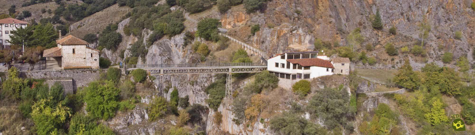
We leave behind us Ortigosa de Cameros (0h 00min) to descend along the road that leads to the village. Behind us is the hermitage that we entered the previous day. Almost without noticing, we take the turning that leads to the hamlet of Peñaloscintos, the asphalt is the main feature of this initial stretch.
The panoramic view to the reservoir of González Lacasa dominates our entrance to the village of Peñaloscintos (0h 12min). After passing by the church and descending a flight of steps you head towards the cemetery of the village. We leave the cemetery and Peñaloscintos behind us to follow for a moment the road that the street we were walking on has become. We quickly say goodbye to the road to follow the path that we find in the middle of a bend. We cross a cattle porthole to border a meadow and begin an ascent through a forest in search of another porthole that we will also have to cross.
After a short while we will reach a clearing in the forest, which we will cross and begin a gentle descent. This descent will lead us to a new path that we will have to follow for a few metres.
We will soon find ourselves descending between some old stone walls that precede the uninhabited village of El Hoyo. Here we come to the junction that joins the GR 93 with the GR 190 of the Iberian High Valleys in Villoslada de Cameros. We leave this fork and the uninhabited village behind to continue descending towards the bottom of the ravine. In this section we will have to cross an earth slope to be able to continue descending in search of the bottom of the ravine, a descent that leads us to a wide track along which we will continue. This part of the route takes us to the bridge that crosses the Iregua River and that will allow us to enter Villanueva de Cameros (2h 09min).
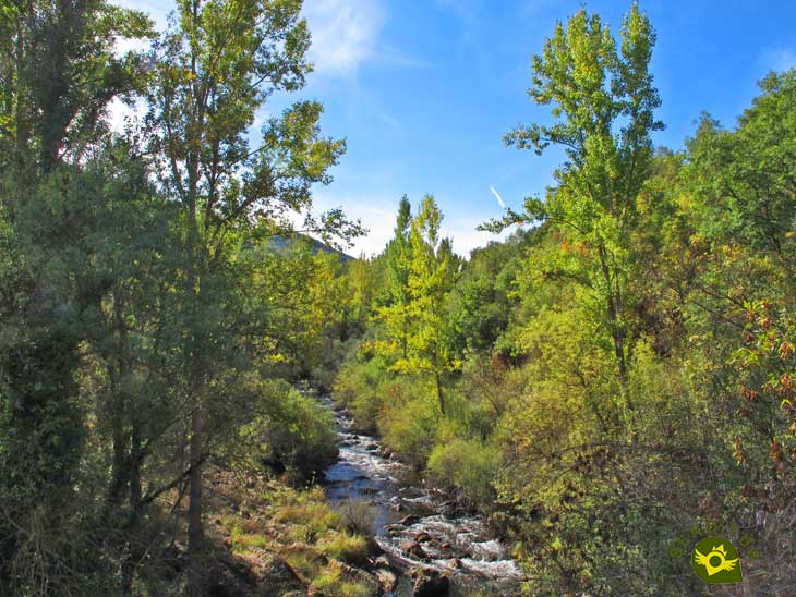
The national road and the GR 93 markings take us to the doctor's surgery building, where the steep path that we must follow begins. We go round some houses to head towards the hermitage where the path that will take us definitively out of Villanueva de Cameros awaits us. After a steep ascent, and just after crossing another porthole for cattle, the path begins which, cutting through the mountainside, will guide us on this part of the route. A little further on and after enjoying the views, we begin the descent that will take us into a beech forest. When we come across the stream that runs through it, we will have to go upstream in search of the place where we can cross the wire fence that separates the municipalities of Villanueva and Gallinero. We will have to cross the stream and ascend towards the pass that separates the two sides. From the pass we start the descent that will take us to the village of Gallinero de Cameros (3h 12min).
The GR 93 crosses Gallinero de Cameros following the Calle Real. On the outskirts of the town we have to ford a stream to begin the ascent ahead of us. In the middle of the bend the path awaits us, which we must follow and which will lead us to a new pass. Cross this pass to continue the ascent through bushes. After a while we will find ourselves bordering a meadow to change direction and cross a couple of dirt tracks. Almost without realising it, we reach the path that climbs up to the Libarache refuge, where we are heading. The tough ascent ahead takes us to the junction with the path that leads to the meadows of Libarache, where the aforementioned refuge awaits us. The views from here are unbeatable. We say goodbye to the refuge as we cross the meadow approaching the limits of the beech forest that flanks it.
Once there, follow the path to the right. We will have to go through another porthole to ascend among pines following the trodden path that now acts as a guide.
The Horquín firebreak forces us to make one more effort, the col of the same name marks the dividing line between the Iregua and Leza basins. Here the GR 93 markings make us change firebreak, losing some of the height we have gained. Once again we have to cross a wire fence and a new path to head towards what looks like a hut. We leave this hut behind us and enter the thick forest while we continue descending along a well-defined path that takes us to another water supply hut. We continue descending and after a short while, after a change of orientation, we begin a much steeper descent. After a while we will have to say goodbye to the path we are now descending, to follow a path through the forest. Once again we begin another steep descent that takes us to a stream that we will have to ford. After ascending for a few minutes we will come across a path which we must follow. When we reach a crossroads we start a gentle descent to the final stretch that will take us to the hermitage of Santo Domingo where we enter Laguna de Cameros (5h 36min), the end of this stage of the GR 93.
 |
 |
 |
 |
 |
| 1-Ortigosa de Cameros | 0:00h | 1050m | 0km | 30T 524721 4669616 |
| 2-Peñaloscintos | 0:12h | 1052m | 2.75Km | 30T 526240 4669027 |
| 3-Villanueva de Cameros | 2:09h | 880m | 8.31Km | 30T 528909 4668321 |
| 4-Gallinero de Cameros | 3:12h | 1096m | 11.1Km | 30T 531586 4668981 |
| 5-Laguna de Cameros | 5:36h | 1040m | 20.49Km | 30T 537749 4669169 |
Coordinates UTM Datúm WGS84

.png) Distance: 20.5Km
Distance: 20.5Km
.png) Time: 5:36h
Time: 5:36h
.png) Difficulty: Moderate
Difficulty: Moderate
 Slope: 2398m
 Slope +: 1489m
 Slope -: 909m
 Maximum altitude: 1475m
 Minimum altitude: 880m

![]()
This schematic with the path is approximate and has been created from the derived cartographic base © Instituto Geográfico Nacional "Cuadrante 241-3 y 241-4 1:25.000".
Variant: Link GR93-GR190 Ortigosa de Cameros-Rock Hincada


Find out what to see in...
¿Did you know that...
Both from Ortigosa de Cameros and from the hermitage of El Hoyo there are paths that link the GR 93 with the GR 190, the former in Canto Hincado and the latter in the town of Villoslada de Cameros. This makes it possible to do a circular trekking of several days starting and finishing in Ezcaray.
Don't miss out...
The visit to the Ortigosa caves is a set of very unique caves. There are guided visits to both La Viña and La Paz caves.


From the commitment of SENDITUR with Nature and the respect to the balance of the environment, SENDITUR urges you to travel in a responsible way, with low environmental impact and respecting at all times the Natural, Cultural and Social environment wherever you go.

Besides sharing with all of us your experience on the route we would be grateful if you could write to us to inform us of any erroneous or outdated information you may have found, or simply to let us know what you think at Thank you.
Route information updated on 19-08-2020. The route may vary greatly depending on the time of year, weather conditions and terrain, as well as the actions of third parties and the evolution suffered in the natural environment where it is located. All opinions, advice and/or assessments made by SENDITUR in their descriptions are for guidance only and are subject to and/or refer to the specific conditions of the specific day of the route, referring to that specific day, taken from trained people, with the appropriate experience and with a high level of physical and technical preparation as a reference, as well as correctly equipped.
All the times are approximate and take an orientative character, the stops have not been taken into account, no matter how small they are. All the information related to the route, texts, images, videos, maps, diagrams, tracks, towns, and places of tourist interest are published as a guide, and may not coincide with the current state of each place. Before undertaking any activity, assess your technical knowledge, your physical condition, find out about the weather and the variations that the route may undergo, equip yourself correctly, be prudent and responsible at all times, and do not exceed your capabilities. SENDITUR is not responsible for any misuse or inappropriate use of the comprehensive guides of its routes and/or publications as well as its electronic guides, nor for any variations in their descriptions for the aforementioned reasons, and recommends that everyone be responsible and prudent in carrying out the activity. We also encourage you to read books and specialised guides to complement the information described above.
Continue watching …


 Previous: Section 3 Anguiano-Ortigosa de Cameros
 Next: Section 5 Laguna de Cameros-San Román de Cameros


.jpg "Go to Monastery of Valvanera")
.jpg "Go to Monastery of Suso")


