Welcome to SENDITUR.COM · paths · routes · tourism

Grassland of Puras de Villafranca
Puras de Villafranca, Burgos![]()
![]()
![]()
![]()
![]() (1)
(1)
On horseback between La Demanda and the Mountains of Oca
![]() Difficulty-Medium
Difficulty-Medium
![]() 2:30 h.
2:30 h.
![]() 10.8 km.
10.8 km.
Puras de Villafranca, Burgos![]()
![]()
![]()
![]()
![]() (1)
(1)
On horseback between La Demanda and the Mountains of Oca
![]() Difficulty-Medium
Difficulty-Medium
![]() 2:30 h.
2:30 h.
![]() 10.8 km.
10.8 km.
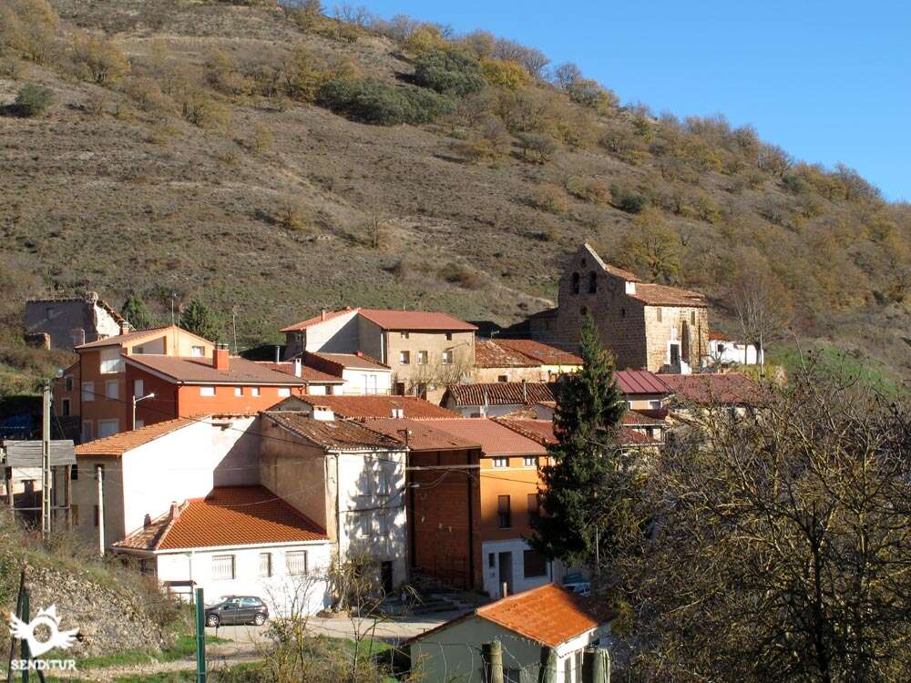
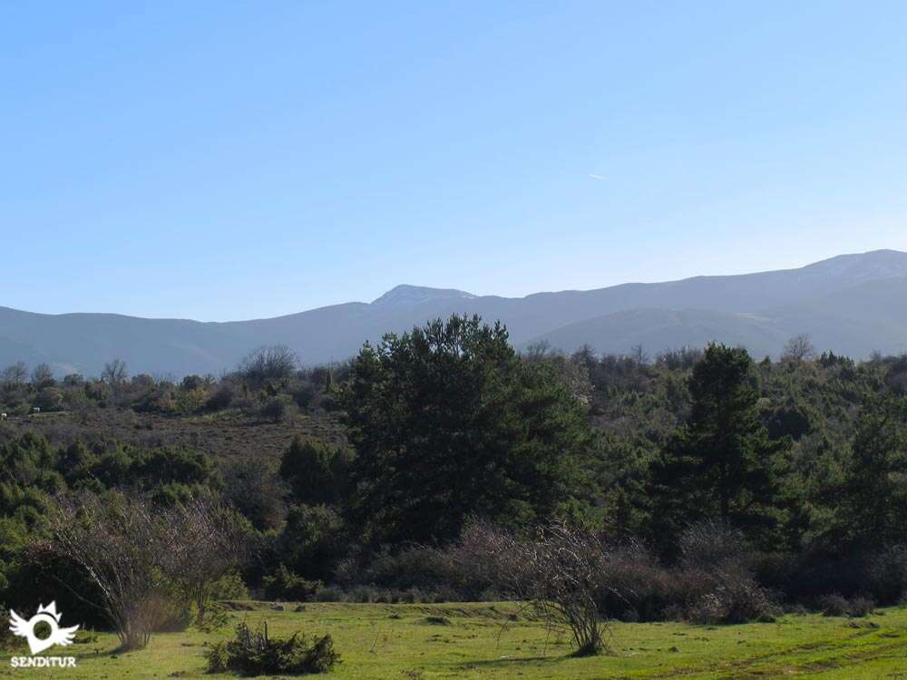
In the foothills of the range of La Demanda and Mountains of Oca is the extensive grassland of Puras de Villafranca, to whose large area we must add, among other things, the characteristic of being a grassland of beeches, something not very common for this type of land in which the rebollares and holm oak among others, are the most abundant. Puras de Villafranca is a town belonging to the municipality of Belorado, whose livestock industry has coexisted for years with a flourishing mining industry whose scars now form a tourist mining complex.

The route with just 10.8 km transports us from Puras de Villafranca, where its church of San Martín Obispo stands out from which every year a pilgrimage is held to the hermitage of San Quirico and Santa Julia which observes us at the top of its hill, at the beginning of the route. As it could not be less, the Puras de Villafranca Mining Complex comes to our meeting showing us part of the intense work that used to be done here, the mines, the wells or the buildings that made up this industry, are a great museum that tells us about the special composition of the terrain through which this route runs. Land that not only kept in its bowels the coveted manganese, but also hides a complex network of karst formations more than 35 million years old whose greatest exponent is the Cave of Fuentemolinos, one of the most important of its kind in the world. A terrain that thanks to its composition has propitiated the true natural park in which the beech grassland of Puras de Villafranca is converted today.

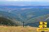
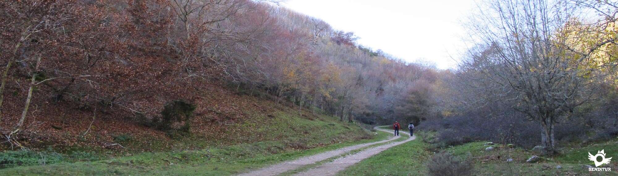
There are beeches of singular forms and great sizes whose antiquity in many cases surpasses the 100 years and that accompanied us in great part of the route while we enjoyed this grassland almost unique in its genre and one of the of greater extension of the province of Burgos. The streams and valleys are the ones in charge of guiding us on a route that goes up the rounded hills that surround us, discovering every corner of this land while we climb the high plateau where a magnificent balcony awaits us from where we can enjoy the privileged view from it. The wide summit of Cabeza de Muladardo allows us to contemplate a wide extension of the range of La Demanda with San Millán Peak and San Lorenzo in front. Also extends before our eyes the region known as the Riojilla Burgalesa, the valley of the river Tirón and the Mountains of Oca, forced passage of the Way of French Santiago towards the plateau of Burgos. This part of the route crosses this natural border that separates the valley from the mountain range, in which the robust beech forests have given their protagonism to the holm oaks and the rebollares in search of the descent that will make us return to Puras.

The Urbión river valley and the villages located in it will accompany us in this section of the route as we advance along the edge of the mountain before it rushes to the bottom of the valley. After a quick descent, another of the deep breccias exploited by the mining industry to extract ore welcomes us to Puras de Villafranca, the starting and ending point of this route.
In order to reach Puras de Villafranca we will have to cross the river Tirón and we will do it through the Devil's Bridge where, according to legend, there live beings with the body of a woman and the feet of a duck who allied themselves with the devil to try to prevent the construction of the bridge by throwing it down again and again with successive floods when it was already finished. Impotent to the advance of man today are dedicated to scare and annoy bathers who enjoy the summer months in the quiet backwaters and pools that are located in the vicinity.
The access road to Puras de Villafranca is found shortly after leaving Belorado, in the middle of the N-120 between Burgos and Logroño, direction Pradoluengo by the BU-811 that joins both localities. As soon as you take the detour on this road, you will come to a new crossroads where you will take the narrow road that leads to Puras de Villafranca. Once there and just at the entrance to the locality we will have the sign that on our left indicates the access to the reception centre for visitors to the mining complex. We can leave our vehicle either around it or going up the street that borders the river and brings us closer to the starting point of the route.
Good route for our friend where neither the distance nor the unevenness should be a problem for him, in addition the terrain should not cause problems in the legs either since it alternates several types of pavements and grass areas. Beware of barbed wire fences as they have thorns.
We will find several troughs in the first half of the route so the water, except on rare occasions, should not be a problem. Even so, we must bring some food and water, especially in summer, as we will not have any shade where it can cool down.
We will cross a cattle area par excellence, so cows, horses and flocks of sheep are common. For that reason, to the logical precautions in this type of routes, it is not too much to add a small revision when arriving home, that serves us to avoid to him annoying parasites.
The beginning of the route is located under the hermitage of San Quirico and Santa Julia which dominates the whole of Puras de Villafranca (0h 00min) on top of its hill.

A big poster of the mining complex informs us of the basic data of the route, at the same time that it marks the beginning of the path that we must follow.

At the moment we find the first fork, the valley where the creek that reaches Puras flows is the one in charge of guiding us in this part of the route.

We say goodbye to the building of the old offices of the mines next to the detour that takes towards the different wells that exist here, to continue the straight course that marks us the track by which we go. Quickly we find the informative sign of the Cave of Fuentemolinos and the path that to our right leads up to it.

The slope does not suppose a great effort practically in all the itinerary, since from a first moment we began to gain height, leaving every time more down the stream that accompanied us from Puras. The good state of the track and its amplitude together with the marks of the route facilitate us to follow the route with facility.

The landscape allows us to observe the different rock formations that have been formed over the years, while we continue climbing up the valley interspersing areas of greater unevenness with others that are practically flat.

We leave behind a path that on our left begins to go up the slope of the hill to follow the course of the valley surrounded by the soft mountains that form it.

The beeches, the holm oaks and the different tree species that inhabit here offer us a magnificent spectacle full of color as we advance without major difficulties. At each step we are surprised by the wingspan and the curious shapes of the large trunks of trees that surround us.

The valley is losing width forcing our way to meander between the slopes of the mountains that box it at the same time that we gain height at each step. The old marks of the PR that we are crossing still resist the passage of time giving us one more reference next to the signs that indicate the route.

There are several troughs for livestock next to which we are going to pass as we continue to gain height and the valley begins to give way to more open areas. The grassland continues to maintain its livestock activity in the green pastures that compose it and that sometimes cover the path we walk.

The rolling of the vehicles that have passed through here serve as a reference to follow in case of doubt, although as usual we continue to leave behind us all the roads with which we are encountering. Almost without realizing it, we have left the valley behind and we pass through the pasture, getting closer and closer to the plain that awaits us further on.

Almost at the same time that the silhouette of the great peaks of the range of La Demanda is shown before us, we find a first crossroads where we continue along the path on the left that descends a few meters.

At the moment this path divides again, we in this new crossing must follow the path on the right that maintains a gentle slope leaving the left that gains height more noticeably. A few metres further on we come across a mark on the route which confirms the correct choice made at the previous junction.

The vegetation returns to cover the dirt track at the same time that we pass next to the remains of the old shelters of the shepherds that resist in disappearing of the whole of this landscape. The route brings us closer to the edge of a leafy pine forest while continuing to make us gain height.

For the moment we will continue bordering the forest of pines whose border is to our right. There are not many paths that we find in this stretch and normally if we follow them we would enter the forest, but for now we still do not enjoy the shade it offers.

Our track also seems to want to enjoy the little shade that the route offers and introduces us to the pine forest where the mud forces us to move forward looking for the best areas to pass.

This short stretch of forest ends suddenly giving us a splendid panoramic view of the range of La Demanda that extends before our eyes. Here the route turns to the left bordering the forest at the same time that separates us a few meters from its border. The blurred road leads us to a nearby mound of earth where a sign verifies the right course chosen.

We are in the wide plain that forms the Muladardo's Head (1h 40min) and whose true top hides among the bushes that flank us. As soon as we pass this cobblestone mound we find a new fork, if we look closely at the grove that divides the roads we will see the marks that indicate the direction to follow.

The route follows the path on the right, taking us through the wide plain and allowing us to contemplate the region of La Riojilla Burgalesa, which extends to our left as we advance.
.jpg "In some stretches the tread tracks help us to follow the right course")
In this area the route is somewhat more difficult to follow due to the state of the road almost diluted by the grass that covers it, being the rolling of the vehicles that deepen the terrain, some solitary mark and the proximity of a fence, the only references that will serve us to continue the route correctly.

This part of the route runs almost entirely with the mountains of La Demanda on our right, at the same time as we border the valley of the river Urbión. The path draws different routes in search of saving muddy sections that maintain their state after the last rains.

The route takes us away and brings us closer to the barbed wire fence that delimits the plateau along which we walk with the valley that flanks the route. When the path seems to take us away from the limits of the valley, the marks of the route bring us closer to it so that we can continue enjoying the landscape that surrounds us.

The absence of obstacles allows us to contemplate, on clear days, a wide panoramic view of the horizon at the same time as the course that follows the path we are following. After a while we began the descent, saying goodbye to the comfortable route we were following.

The road bids farewell to the barbed wire fence that accompanied us for a while to meander among the holm oaks seeking to lose height quickly as it leads us towards the valley through which we will head towards Puras.

After steep ramps we reach the bottom of the valley where another fence forces us to turn sharply to continue the descent next to it.

This part of the route follows a well-marked path that in progressive descent leaves no room for many doubts in the few junctions that we find. The Aguas Puras valley is opposite us, indicating the proximity of the end of the route and the descent we are making.

An improvised gate that prevents the passage of cattle blocks the road, here the route crosses this gate to follow its course. The trail that starts at this point gives us the option to follow it bordering the fence and resume the route just at the entrance to Puras. We follow the path that already allows us to contemplate the first houses of Puras among the grove.

Another of the mining wells found here is the one in charge of welcoming us to the locality, which we enter after crossing the river that bathes it.

From here we will only have to travel the few meters that separate us from the place where we started this route in Puras de Villafranca (2 h 30min) and that is where it also ends.
 Distance. 10.8Km
Our tour of the mining area will be the most likely to increase this figure.
 Time. 2:30H
The time we spend photographing and enjoying the environment around us is what will condition the duration of the route as we will not have alternative detours that make us add minutes to this tour.
 Time of year
Although throughout the year we will find more than enough reasons to justify this tour, in autumn we will find a spectacular and colorful landscape that will make it even more interesting. Spring and summer give us days of very good visibility that will allow us to contemplate in detail the landscape that surrounds us. The winter, hard for these lands, can come to offer us a good option for the lovers of the routes with snowshoes, whenever we have the sufficient experience realizing routes of this type.
 Required equipment
In summer or on hot days it is essential to carry water because except in Puras, we will not have fountains where we can drink all along the route. Clothes and sports shoes like hiking shoes, always adapted to the weather conditions and the time of year, is all we will need in normal conditions. The mud can complicate some stretches of the route so having a spare shoe in the car can be a good idea. The protection against the sun can't be absent either since we will hardly have shade areas in all the route. The canes are always of great help and more if we walk among the cattle, also can not miss a map or GPS with the tracks of the route, which even being well signposted is difficult to follow if we are surprised by the fog. Consult our list of material and equipment for hiking. Read more.
 Difficulty. Medium
Physical
Both the distance and the unevenness to be covered are perfectly acceptable for someone who is used to walking, and if we give ourselves enough time, we can take the route with the necessary calm on the short ramps we have to face.
Severity of the environment
As long as we do not go out of the marked route we will not have any difficulty since this one normally transits by tracks in good state, being the mud and the fast final descent the reefs that more can complicate the day and where more attention will have to pay to avoid slips.
Orientation
The route is well signposted, rarely coincide the signs of the route with the old marks of the PR that transited here. In normal conditions and except for some point where the signs force us to look for them more carefully, we would not have to have more complications to follow the route. If, on the other hand, we find fog or snow, the difficulty of following the marks is considerably extended because they are quite separate from each other in areas where the road is not so marked because of the grass that covers the ground, also in some cases the signs are almost flush with the ground so the snow can cover them easily.
 |
 |
 |
 |
 |
| 1-Puras de Villafranca | 0:00h | 903m | 0Km | 30T 479998 4691793 |
| 2-Cabeza de Muladardo | 1:40h | 1173m | 5.9Km | 30T 479348 4688443 |
| 3-Puras de Villafranca | 2:30h | 903m | 10.8Km | 30T 479998 4691795 |
Coordinates UTM Datum WGS84

 Slope: 687m
 Slope +: 343m
 Slope -: 344m
 Maximum altitude: 1173m
 Minimum altitude: 903m

This sketch of the route is not made to scale nor does it contain all the information relating to the area, it is merely indicative.

![]()
This schematic with the path is approximate and has been created from the derived cartographic base © Instituto Geográfico Nacional "Cuadrante 201-4 1:25.000"
Senditur has manipulated the tracks to correct the aberrant points that may exist, caused by problems with the reception of the GPS signal. In any case the tracks are always approximate. SENDITUR encourages you to use the new technologies within your reach, using them as support and consultation in your activity, not basing the realization and orientation of the same only and exclusively on them, since they may see their functioning altered by very diverse causes, not functioning correctly and their indications may not be precise.


Bonito paseo el que hicimos por este lugar entre bosques, con bucólicos parajes y vistas espectaculares de los picos de la Demanda, el San Millán estaba precioso. Terminamos el día con una divertida visita a las minas de manganeso, los niños disfrutaron a rrabiar pero los mayores no nos quedamos atrás.
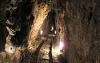
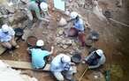
Manganese mines whose exploitation is probably one of the oldest in Spain
Great encyclopedia of the evolution of man, natural treasure kept in time

Find out what to see in...
¿Did you know that...
The main feature of the Cave of Fuentemolinos is its composition of limestone conglomerate known as pudinga, this fact, along with the formations that have been created in it and its extension of more than 4 kilometers, make it one of the most important caves of this type worldwide, being a cave of great beauty and geological value.
Don't miss out...
A visit to the Puras de Villafranca Mining Complex, where besides visiting The Beginning and Pura mines, going into their galleries and putting ourselves in the shoes of the hard-working miners who worked there, we will be able to discover curiosities from their day to day, as well as checking with our own eyes some of the different uses and characteristics that manganese has.


From the commitment of SENDITUR with Nature and the respect to the balance of the environment, SENDITUR urges you to travel in a responsible way, with low environmental impact and respecting at all times the Natural, Cultural and Social environment wherever you go.

Besides sharing with all of us your experience on the route we would be grateful if you could write to us to inform us of any erroneous or outdated information you may have found, or simply to let us know what you think at Thank you.
This route has been carried out in the field by SENDITUR on 08-12-2015. The route may vary greatly depending on the time of year, weather conditions and terrain, as well as the actions of third parties and the evolution suffered in the natural environment where it is located. All opinions, advice and/or assessments made by SENDITUR in their descriptions are for guidance only and are subject to and/or refer to the specific conditions of the specific day of the route, referring to that specific day, taken from trained people, with the appropriate experience and with a high level of physical and technical preparation as a reference, as well as correctly equipped.
All the times are approximate and take an orientative character, the stops have not been taken into account, no matter how small they are. All the information related to the route, texts, images, videos, maps, diagrams, tracks, towns, and places of tourist interest are published as a guide, and may not coincide with the current state of each place. Before undertaking any activity, assess your technical knowledge, your physical condition, find out about the weather and the variations that the route may undergo, equip yourself correctly, be prudent and responsible at all times, and do not exceed your capabilities. SENDITUR is not responsible for any misuse or inappropriate use of the comprehensive guides of its routes and/or publications as well as its electronic guides, nor for any variations in their descriptions for the aforementioned reasons, and recommends that everyone be responsible and prudent in carrying out the activity. We also encourage you to read books and specialised guides to complement the information described above.
Continue watching …


.jpg "Go to Villafranca Puras Mining Complex")