Welcome to SENDITUR.COM · paths · routes · tourism


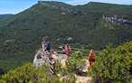
Joar and the Plana from the Sanctuary of Codés
The mountain of many names
![]() Difficulty-Moderate
Difficulty-Moderate
![]() 3:00 h.
3:00 h.
![]() 7.6 km.
7.6 km.
The mountain of many names
![]() Difficulty-Moderate
Difficulty-Moderate
![]() 3:00 h.
3:00 h.
![]() 7.6 km.
7.6 km.
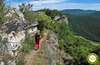
A natural border between Navarre and Alava, the mountain range of Codés is home to a large number of steep mountains from which you can enjoy beautiful panoramic views not only of Navarre and Alava, but also of neighbouring La Rioja. Emblematic vertical cliffs, full of mystery and legend add to the lush forests, especially on its northern slope, forming a true natural temple for hiking and the mountains.

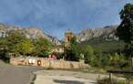
The route that ascends to Joar and the Plana from the Sanctuary of Codés has a distance of just 7.6 km that offers multiple alternatives to those who travel. Starting from the Sanctuary of Codés, temple of the XVI century, we will begin a demanding ascent that will take us to leave at our feet this historical site, plundered by the French troops in the War of Independence and headquarters of the famous guerrilla Espoz y Mina. The route soon puts us fully into the rugged landscape of vertical rocks that characterizes this mountain. The trail to follow shares the route, at least for a while, with the emblematic GR 1, as it ascends the cobbled slope of the mountain observed by the two peaks we are about to climb, the Joar and the Plana. The wide plain of the Col of the Llana marks the point at which, in addition to bidding farewell to the GR 1, the final ascent to both summits begins, one on each side of the col. The Joar, or as it is also known Yoar, The Telegraph or simply Codés gives those who visit it some beautiful panoramic views from its summit, which we can reach through not a few routes.

Once this mountain has been conquered and after returning again to the Col of the Llana, we will undertake the ascent to the summit of the Plana, but not without first saving an aerial crest that makes this mountain route even more interesting, or we will return to the Sanctuary of Codés following the same steep and decomposed trail we climbed. These mountains, although not very high, do offer us the possibility of experiencing the environment that is breathed in supposedly larger mountains. From the summit of the Plana and after bidding farewell to the characteristic mailbox that crowns it, we will undertake a long descent through the mountain range that enters Navarre and then recover the lost orientation and set a new course for the Sanctuary of Codés, with our sight set on the unmistakable silhouette of the Joar that will accompany us until the end of this hiking route.

Legend has it that the different needles that can be seen in the mountain range of Codés or in its well-known Valley of the Penitents, are actually people that one day wandered lost by the mountain and that thanks to the magic that surrounds this place ended up becoming vertical rocks forever. As happened to the two orphaned sisters who, fleeing from their evil stepmother, entered the mountain never to return, or to the abbot of the sanctuary, the declared enemy of the famous witch of Bargota, who one morning disappeared taking a quiet walk and was never seen again. The locals claim that the morning after each disappearance as many rocks arose from nowhere as many people would have disappeared.
To get to the Sanctuary of Codés we have to follow the road that joins Torres del Río, in the old national road between Logroño and Pamplona, with Aguilar de Codés, which we can reach from Viana, from Lapoblación or from Santa Cruz de Campezo in the north face of the mountain range. It is on this road between Torres del Río and Aguilar de Codés where you will find the detour which, after passing through the town of Torralba del Río, ascends to the sanctuary. This same road but in the other direction reaches the sanctuary after passing through Cabrega or Mirafuentes among other towns, from the NA-129 that joins Los Arcos and Acedo. Once in the sanctuary we will have a first car park next to the road, but our route begins in the car park that we will find a little higher and that we will arrive at after leaving the main road and ascending by the track that borders the sanctuary leaving it to our right hand.
Entertaining hiking route for our dog in which he will have sections through thick forests, others with a certain slope and quite cobbled that will undoubtedly put him to the test and also pleasant trails and paths, in short a demanding route but full of stimuli for him that will make him enjoy the day.
It is important, as there are no water points along the route, that we do not forget to bring him his corresponding ration along with some food to help him recover from the effort of the ascent.
We will travel through areas in which we can find hunting beats, when it is clear its time. In addition it is necessary to add the fauna that, although fleeing, inhabits this mountain.
The car park in the upper part of the Codés Sanctuary (0h 00min) marks the starting point of this mountain route in Navarre.

Crossing the track by which we ascended until the parking lot we will find with the way that we must follow, embedded between the solitary and battered informative signs of the place.

At the moment we begin to notice the unevenness that we are going to have to face, without almost allowing ourselves to get warm, while our path, clearly stepped on, is also marked by the characteristic signs of the GR, which will accompany us for a good part of the ascent.

We advance gaining height with each step with our eyes set on the imposing walls towards which we are heading. The paving of the path together with the clear unevenness that we are saving make us advance with difficulty.

There are not many roads or possible detours with which we will meet and generally in all of them is very clear the direction to follow.

Soon the track is losing width, at the same time that we begin to face some hard ramp. After a while, when the slope seems to give us a little respite, we find a new crossroads, here the GR marks encourage us to follow a narrow trail to our left.

From now on, there will be many hypothetical shortcuts or different trails with which we will meet and which will force us to decide which route to follow, or better said, which will give us the opportunity to choose the hardness and difficulty that we wish to apply to our ascent to the Yoar. We continue straight ahead, leaving behind the detour, in search of a somewhat softer profile in exchange for a despicable greater distance.

We quickly find ourselves before a steep plasterer through which we will ascend following the winding course of our trail.

We gain height quickly and not effortlessly, struggling not to lose foot and get to advance with each step. The impressive needles that surround us are mute witnesses of our effort, which fortunately we will soon see partly lowered.

In front of us, threatening, is one of the various trails by which we can face this stretch. Luckily, we have the possibility of continuing to gain height without the need to harden the ascent even further.

We zigzagged through the vegetation, leaving behind the vertical needles we used to contemplate.

Now we will have to face a steep stretch of the ascent that in normal conditions has no greater complication than being attentive to what we do.

Once again the trail is clearly defined and leads us to the nearby hill towards which we are heading. We still have a steep slope before reaching the plain that awaits us a little further on.

As we get closer to it we will come across more than one trail on our left that invites us to take a detour to continue up the Joar. The Pass of the Plana (1h 00min) greets us with the crossing of paths that lead to the two summits that we are going to crown in this route.
Once again we have the possibility of choosing the intensity and difficulty of our route, advancing a little further along the path that has become our trail we will find the detour that will allow us to face a gentle slope initially.

Or we can also take one of the trails on our left that, in exchange for a greater effort, shorten the route we will have to follow.

In the first case, already in full plain we will find the solitary stone, just before arriving at a post of the GR of which we say goodbye already, that marks the path to follow.

In all the cases we will begin the ascent by the shoulder of the mountain in direction to a dense forest that waits for us above. On clear days, the antenna that crowns the mountain can serve as a reference to follow in the labyrinth of trails that cross its slope.

The slope becomes noticeable again at the same time as we leave on our right the railing that separates Navarre from Alava.

Once inside the forest, the leaves that cover the ground make it difficult for us to follow the path that leads to the summit.

Luckily the tread of the route next to a few small red dots helps us in case of doubt.

After a while our trail meets the track that gives access to the antennas of Mount Joar. We ascend by the track the few meters that separate us from its wide summit.

Once up we turn in round to go towards it, bordering the enclosure of the antennas.

A little further on from the geodesic vertex we will come across the cross on the top and a little further on we will come across the characteristic mailbox that marks the summit of Mount Joar (1h 30min) or Yoar as it is also known.
Enjoying the marvellous landscape that this mountain offers, we undertake the descent following the steps that brought us here.

In the descent we can clearly observe the next mountain to which we are heading. The Pass of the Llana (1h 45min) awaits us to force us to decide the route we want to follow.

Just before starting the steep descent towards the sanctuary, route to follow for those who go directly to it by the same route we climbed, is the path that leads to the Plana. Before venturing into this part of the route we have to assess the ridge we are going to face, as it undoubtedly increases the difficulty of the route.

This is not too complicated or too long a step for someone accustomed to this type of terrain, but it can impose air more than one and does not give much scope for slips or trips. It is true that it can be avoided by skirting it from below, but not without some difficulties.

We begin the ascent by following the trail behind the hill. The slope is important again, forcing us to take it with a certain calm.

The trail brings us for an instant closer to the vertical walls as if we wanted to get used to what awaits us above.

Soon we will approach the limits of the forest that populates the slope of the mountain. We continue to gain height quickly, protected from the void for now.

The trees, at the same time that the trail disappears, give way to a cobbled wall that we will have to climb.

Once up we will find ourselves face to face with the ridge that the most intrepid must follow. This part of the route is marked with blue marks to the sanctuary itself.

Those who do not want to take the risk of riding the ridge have the possibility of saving it on the left side, as we ascend.

Losing some height, to reach the base of the stone wall and the boundaries of the forest, we can pass not without some difficulty.

Without a defined path or trail we will have to save every obstacle that we will find, without losing too much height.

Almost without realizing it we will see ourselves recovering the lost altitude to accede to the top towards which we go.

Once up and after looking back to see the crest that we have either crossed or we have bordered, we go to the nearby summit of The Plana (2h 10min).
After contemplating the magnificent landscape that surrounds this summit we undertake the descent following the top shoulder, opposite to the crest that we have just surpassed.

We walk this shoulder almost to its end, to find a lonely post, time to change our course.

We turn right to start a quick descent down the long southeast ridge of the mountain.

Soon we will come across the trail that we must follow and that will partly facilitate our way to the sanctuary of Codés.

As in the ascent there will be several possible trails that we can follow, some closer to the apex of the ridge, others further from it, but all with the same direction.

The descent is longer than expected, but the views it offers compensate for the tiring tracing.

Shortly before reaching some solitary and vertical needles, we will find a new detour marked by a small stone milestone.

We will have to be careful not to skip it, although if this is the case at the moment we will have a new crossing that will allow us to correct the course to follow.

We now descend away from the fine stone needles that once served as a reference. The path soon turns round and begins a dizzying descent with its eyes set on the Monte Yoar.

A long stretch of narrow, cobbled track still awaits us before we reach our destination.

After a while the trail ends suddenly when we come across a way that we must follow.

Almost without having become accustomed to the relative comfort of the way we will arrive at a new detour that will avoid us to cross the wide curve that this one draws.

This short stretch of trail ends again in a new dirt track which we will continue for a few metres.

At the moment, on our right, we find the track that we had previously abandoned and a new track that we will continue leaving behind the track we had brought, which leaves the nearby road.

This new trail after passing by a small house takes us to the vicinity of a watering hole. Just before reaching a diluted arrow painted on the trunk of the tree that precedes the trough indicates that we must continue down our left.

We will quickly pass by some corrals sensing the proximity of the end of this hiking route.

The battered track takes us directly to an encementada track that from the nearby road will take us to the Sanctuary of Codés.

All we have to do is follow the track without any more detours, unless we dare to visit the Shrine.

Our track takes us directly to the Sanctuary of Codés car park (3h 00min), from where we start the route and where we will put a stop and end.
 Distance. 7.6Km
Returning by the same route, without doing the circular route, does not subtract as much distance as might be expected.
 Time. 3:00h
The unevenness, added to the decomposed and slippery trail that connects the Sanctuary of Codés with the hill of the Llana, is almost without a doubt what will most condition, apart from our physical condition of course, the time we will need to make this hiking route.
 Time of year
Its low altitude does not devalue the beauty and the mountain environment, worthy of the highest peaks, that this mountain offers to those who dare to conquer it. Although this summit is quite accessible under normal conditions and always depending on the route we choose or the conditions we find, this mountain and its companion the Plana, thanks to its solitary location offer a magnificent balcony from which to contemplate as far as we can see, Navarre, Alava and nearby La Rioja. Autumn with its striking colours or winter with its white and crystalline mantle, reserved for more experienced mountaineers, provide a magnificent incentive to this attractive mountain route.
 Required equipment
Except in the sanctuary we will not have more water points so it is advisable to take water and food in the backpack. The canes will surely be of great help in the ascent but even more in the descent. The gravel and the slope of some sections suggest that we wear boots or slippers prepared for this type of terrain. It is not so strange to meet people who come to know the sanctuary and venture into the mountain without the recommended material and minimum information. Another point to take into account is the difference in temperature and time we can meet once we reach the pass so it is not too much to wear some short wind clothing or raincoat. Consult our list of material and equipment for hiking. Read more.
 Difficulty. Moderate
Physical
The strong ramps that we will have to confront to save the unevenness that we have in front will force us to take us with calm the ascent. Although once we get to the hill the slope is not so demanding, there are still some stretches waiting for us that will again require extra effort.
Severity of the environment
The path, as a general rule, avoids exposing ourselves to the steep walls that surround our route. The great threats that we will have to face, as long as we are talking about the state of the route being that of summer conditions, without snow, ice or rain, are the slippery and steep of some ramps that we will pass through, especially if we go down the same itinerary, the possible fall of stones and the aerial, although not too complicated crest that leads to the top of the Plana, a stretch that we can and must avoid if we are not accustomed to this type of terrain.
Orientation
On more than one occasion we have to find the doubts generated by the many paths and shortcuts we have to find, especially in the area of the hill and the final climb to Joar. It is in this part of the route where we will have diverse options to confront the final ascent. We must also be clear about the marks to follow at all times, especially if we make the circular route, as we alternate red and blue points, depending on the stretch in which we are, as well as coinciding with the marks of the GR that crosses this mountain range.
 |
 |
 |
 |
 |
| 1-Sanctuary of Codés | 0:00h | 797m | 0Km | 30T 554335 4719185 |
| 2-Col of The Llana | 1:00h | 1200m | 1.8Km | 30T 554151 4720552 |
| 3-Joar | 1:30h | 1417m | 2.8Km | 30T 553372 4720452 |
| 4-Col of The Llana | 1:45h | 1200m | 4.1Km | 30T 554151 4720552 |
| 5-La Plana | 2:10h | 1338m | 4.8Km | 30T 554735 4720541 |
| 6-Sanctuary of Codés | 3:00h | 797m | 7.6Km | 30T 554335 4719185 |
Coordinates UTM Datum WGS84

 Slope: 1560m
 Slope +: 780m
 Slope -: 780m
 Maximum altitude: 1417m
 Minimum altitude: 797m

This sketch of the route is not made to scale nor does it contain all the information relating to the area, it is merely indicative.

![]()
This schematic with the path is approximate and has been created from the derived cartographic base © Instituto Geográfico Nacional "Cuadrante 171-2, 1:25.000"
Senditur has manipulated the tracks to correct the aberrant points that may exist, caused by problems with the reception of the GPS signal. In any case the tracks are always approximate. SENDITUR encourages you to use the new technologies within your reach, using them as support and consultation in your activity, not basing the realization and orientation of the same only and exclusively on them, since they may see their functioning altered by very diverse causes, not functioning correctly and their indications may not be precise.


La subida por el valle de los Penitentes es algo espectacular. http://alavaentusbotas.blogspot.com.es/2014/12/al-monte-yoar-por-el-valle-de-los.html Una experiencia inolvidable.


Es un recorrido muy bonito, nosotros no fuimos hasta La Plana y bajamos por el mismo sitio, algún resbalón nos dimos pero con cuidado no hay problema.


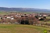
Between the mountains and the Middle Zone of Navarre

At the bottom of a valley near a river and as horizon the sky

Find out what to see in...
¿Did you know that...
Formerly, before the Sanctuary of Codés was built in its present location, there was a small hermitage next to the cave where an image of the Virgin and Child is said to have appeared, back in the 14th century.
Don't miss out...
The Azuelo or San Jorge Monastery, located in the nearby town of Azuelo. From the old monastery, only the church remains, although remains of its original structure have been found. Its origins are not entirely clear but we are in front of a real jewel of Romanesque that is worth visiting.


From the commitment of SENDITUR with Nature and the respect to the balance of the environment, SENDITUR urges you to travel in a responsible way, with low environmental impact and respecting at all times the Natural, Cultural and Social environment wherever you go.

Besides sharing with all of us your experience on the route we would be grateful if you could write to us to inform us of any erroneous or outdated information you may have found, or simply to let us know what you think at Thank you.
This route has been carried out in the field by SENDITUR on 08-01-2017. The route may vary greatly depending on the time of year, weather conditions and terrain, as well as the actions of third parties and the evolution suffered in the natural environment where it is located. All opinions, advice and/or assessments made by SENDITUR in their descriptions are for guidance only and are subject to and/or refer to the specific conditions of the specific day of the route, referring to that specific day, taken from trained people, with the appropriate experience and with a high level of physical and technical preparation as a reference, as well as correctly equipped.
All the times are approximate and take an orientative character, the stops have not been taken into account, no matter how small they are. All the information related to the route, texts, images, videos, maps, diagrams, tracks, towns, and places of tourist interest are published as a guide, and may not coincide with the current state of each place. Before undertaking any activity, assess your technical knowledge, your physical condition, find out about the weather and the variations that the route may undergo, equip yourself correctly, be prudent and responsible at all times, and do not exceed your capabilities. SENDITUR is not responsible for any misuse or inappropriate use of the comprehensive guides of its routes and/or publications as well as its electronic guides, nor for any variations in their descriptions for the aforementioned reasons, and recommends that everyone be responsible and prudent in carrying out the activity. We also encourage you to read books and specialised guides to complement the information described above.
Continue watching …