Welcome to SENDITUR.COM · paths · routes · tourism


![]() Difficulty-Medium
Difficulty-Medium
![]() 1:50 h.
1:50 h.
![]() 5.6 km.
5.6 km.
![]() Difficulty-Medium
Difficulty-Medium
![]() 1:50 h.
1:50 h.
![]() 5.6 km.
5.6 km.
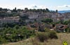
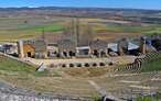
In the same foothills of the Natural Park of the Hoces of the Duratón River, perched on one of the first folds that it has been forced to draw, awaits the historic medieval town of Sepulveda, the start and end point of the Trail of the Two Rivers, a journey that will allow us to know part of the cultural heritage that this town treasures, while we discover the great natural value that since its first steps keep the Hoces of the Duratón River.

The route through its 5.6 km draws a circular route transporting us almost in the time, thanks to the different corners that we will be visiting. Starting from the old church of Santiago, now the House of the Natural Park of the Hoces of the Duratón River, we will undertake a journey through the rich history of Sepulveda, visiting its old prison, the curious Main Square presided over by the remains of the old castle of the town in whose tower La Queda is still preserved, the name given to the old bell to whose replica the doors of the town were closed in the past. The route leads us along the wall to enter the heart of Sepulveda through the Ecce Homo Gate and to the church of the Virgen de la Peña, patron saint of the town. There we can approach to the wide viewpoint from where we will contemplate the capricious course of the Duratón River, besides we will be able to also descend to the hidden cave where the image of the Virgin appeared. A pleasant walk leads us out of Sepulveda to another of the seven gates of this town. The Gate of the Force precedes the descent that will take us to the meeting of the river following the route of the old Roman road that passed through here.

The Picazos Bridge not only allows us to cross the riverbed, but also marks the beginning of the path that runs along its right bank, a path that in a beautiful section runs along the vertical rock wall that surrounds the river. The old power station precedes our encounter with the route of the Trail of the Talcano Bridge and the Villaseca Bridge. Encounter that takes place next to the remains of Talcano Bridge. From here the route takes us back to Sepulveda allowing us to enjoy geological whims such as the Horse Saddle or the fold where the town sits, to go back into the old medieval enclosure after crossing the waters of the Caslilla River through the Gate of the Castro, or what is left of it. Ivy, ferns, the Virgin's shoes, the kingfisher, the blackbirds, plant and animal species that have chosen this unique habitat as their home, come to mind as we approach the Gate of Duruelo. Here we will have to say if we should extend the tour and visit, after crossing the Gate of the River, the old Arab quarter of Sepulveda before putting an end to the route or go directly to the House of the Park, crossing the district of San Andrés thus ending this Trail of the two rivers.

If you prefer to go straight to the House of the Park from the Gate of Duruelo, but also want to know the Arab quarter and the Gate of the River. Or if you did not realise that you could continue the route by crossing the Gate of Duruelo and continuing under the cliff, and then going up it and entering this neighbourhood of Sepulveda, you have the option from the same road that passes by the House of the Park, to access this Arab quarter thanks to the ramp that goes down to it from there. You can also return from the Gate of the Force to Sepulveda directly if you do not want to go through the whole route. To do so, you only have to follow the asphalted track that leads to the Gate of the Force, a track that turns in a roundabout and leaving this old gate behind us brings us closer to the route of the conditioned Path of the Glorieta that allows us to return to the House of the Park.
Various roads lead to Sepulveda, such as the SG-232 which connects it with the nearby A-1 between Burgos and Madrid, at the level of the towns of Boceguillas and Castillejo de Mesleón on the one hand and with Turégano on the other. The SG-241 also reaches Sepúlveda, linking it with Peñafiel, among other towns, or the SG-V-2323, which runs through part of the Hoces of the Duratón river Natural Park. Without forgetting the various options available to us to reach Sepulveda from the N-110 in its section corresponding to the junction between Segovia and the A-1. Sepúlveda has regular bus service that connects it with Madrid, Boceguillas, Santo Tomé del Puerto, Segovia, Peñafiel and Aranda de Duero. Once there we will have to go into the town since the Casa del Parque will be found next to the old route of the road to Segovia, which has become one of the main roads in the town. Due to the difficulty of parking we will have several parking areas available at each entrance to Sepulveda.
We are in a natural park with its own regulation which, although a priori does not make clear the obligation or not to take our dog on a leash, does advise us to do so. For the rest, and except for the urban sections we are before a route of ideal hiking to realize it with our dog.
We can not miss their corresponding ration of water, although certain areas of the river are easily accessible for our friend to quench his thirst. It would not be out of place to bring some food in case a pleasant lunch stop comes up.
This is an area of special ecological value and as such it has specific regulations that protect the flora and fauna that live here, although it is difficult for us to meet other animals face to face beyond the other pets that are in the area.
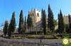
The old church of Santiago, in Sepulveda, is home to the current House of the Park of the Hoces of the Duraton River (0h 00min), the starting and ending point of this trekking route.

We start the route descending to the road that runs through the town to go to the Spain Square.

As soon as we arrive, in front of us and between two historical buildings, we find the street where we have to continue leaving this wide square on our right.

We then begin a rapid descent following the limits of the ancient wall of the town to find ourselves in the middle of a curve with the Gate of Ecce Homo, a gate that we must go through.

We then begin to gain the lost height as we walk through the narrow streets of the historical centre of Sepulveda, without changing our course at the different crossroads that we encounter.

Soon the buildings give way to a more open area where the silhouette of the church of the Virgen de la Peña can already be seen. Just before reaching it our route turns radically forcing us to decide between following it or taking a small detour that will take us to see this beautiful church and the magnificent viewpoint that awaits us right behind.

Of course, we decided to go and see it, so after visiting it, we went to the viewpoint.

A few meters before arriving we are offered another interesting option, to descend to the cave of the Virgen de la Peña, a short but demanding stretch that tempts us on our way.

After visiting the viewpoint and descending to the cave we will return on our steps to the crossroads we left behind before to resume the route we are following.

Practically at the moment we will see each other outside Sepulveda following a conditioned walk. It is not too much to look back and contemplate the unique gorge on which this Segovian town is based.

Our path takes us to a paved track that comes from Sepulveda and will take us to our next objective.

We quickly leave the asphalt track to go to the nearby Gate of the Force (0h 40min), which we will cross.

After passing through the Gate of the Force we begin a rapid descent following the remains of the ancient Roman road that passed through here.

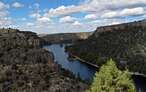
This descent takes us to the very bank of the Duratón River, which is our companion for the stretch of route ahead.

The Picazos Bridge serves us to save the riverbed, just to make it follow its descending course.

From now on we will walk following a marked trail between the riverbed and the cliffs that mark it out. The vegetation almost does not let us contemplate the vertical rocky landscape that surrounds us.

Soon the relative comfort of the trail we follow disappears forcing us to face a hard stretch of ascent.

Section that overcomes the unevenness that separates us from the path that runs in the middle of the vertical cliff that protects this bank of the river.

Luckily the steep slopes do not last long and once again we find ourselves moving forward comfortably enjoying the landscape thanks to the height gained.

Soon after, the riverbank reclaims its protagonism and the path gently leads us back to it. Once again, the vegetation surrounds us, fitting us in between it and the rocky mass that rises above our heads.

Farther ahead, we came across the old dam on our left, which, among its functions, served to regulate the course of the Duratón River. The route continues without detours, approaching with every step the nearby bridge towards which we are heading.

Almost at the moment our route turns abruptly making us descend again in search of the Duratón riverbed.

At the moment we find the bridge that will serve us to cross the river again, leaving on our right the path that leads downstream to the Villaseca Bridge crossing the endless meanders that the Duratón River draws on its way through these lands.

As soon as we cross the river, the old Talcano Bridge (1h 05min) awaits us, which we will not be able to cross due to its delicate state of conservation.
The current route skirts the bridge and undertakes another demanding climb, this time along a wide path.

This is a path that we will not leave at any time and that little by little brings us closer to the parking area from where from the Path of the Talcano Bridge to the Villaseca Bridge begins, and whose route we will follow in this short section.

Once we have crossed this parking area and before the road takes us out, our route forces us to say goodbye to it in order to set off for Sepulveda, but not before visiting a few more corners.

As soon as we climb the stairs that take us out of the way, a wide esplanade opens up before us, offering us a beautiful view and at the end of this esplanade, the continuation of the path that we must follow, which we can reach by crossing the esplanade or by following the path that borders it.

A quick descent ahead of us will take us to the Palmarejos Bridge which will serve to cross the Caslilla River. As soon as we do so, the path turns, making us follow the descending riverbed.

A route that barely lasts a few meters since our path radically changes its orientation to undertake a new area of demanding ascent.

Ahead of us lies a winding and somewhat stony ascent which, although not very long, does require a new effort.

The Castro Gate or rather its remains next to those of the wall that protected this area, accompany us in this part of the route. After the effort and with our eyes already set on Sepulveda, we walk around the limits of the old fences that delimited these fields.

The path seems to take us to the encounter with the road but, just before, it forks allowing us to follow it from the right and thus avoid the asphalt.

Almost without realizing it, we find ourselves before a new gate of the seven that Sepulveda had, the Gate of Duruelo (1h 40min).

Here we have two possibilities, to cross it and follow the path that borders the rocky outcrop on which the town sits, and then go up it to the Gate of the River where we will enter Sepulveda again, and from there climb up to the nearby church of Santiago, the House of the Park, from where we came out, or heeding to the signal and continue on our left without crossing the Gate of Duruelo.
In any case, both routes are considered official, although from now on it will be easy for us not to find any more signs indicating the way to follow.

If we decide to follow the indications of this crossroads, we will immediately start a new ascent that, after passing under the road, will leave us at the beginning of a staircase where we must follow.

This staircase ends when it meets the first houses in the town, leaving us already immersed in the urban layout, the end of the route. We continue to gain height, not without effort, surrounded by the buildings that populate this area of Sepulveda.

The street that we follow takes us directly to the encounter with the road that crosses the town, a road that we will follow.

This road, converted into Sepulveda street, takes us directly to the foot of the House of the Natural Park of the Hoces of the Duraton river (1h 50min), just where those who would have decided to follow the other possibility in the Gate of Duruelo and who arrive here after crossing the neighborhood of San Esteban, will join us to put an end to this hiking route.
 Distance. 5.6Km
The different options we will encounter make this figure more than ever indicative.
 Time. 1:50h
This time takes into account the possible detour to the viewpoint of the Virgen de la Peña and the descent to the cave, but even so can be extended or decreased significantly by the time spent in each place.
 Time of year
Although this is not initially the case, the park usually restricts access to certain areas during the first months of the year to encourage the breeding of the griffon vultures that live here. Otherwise, autumn and spring are ideal months for exploring the corners of this route. In summer the high temperatures invite to take advantage of the first hours of the day to enjoy this beautiful place.
 Required equipment
A route that starts and ends in a tourist town such as Sepulveda, and which also has a stretch of its urban layout, may make us fall into the temptation of venturing along it without adequate clothing and equipment. With no fountains along much of the route, we cannot forget to take with us some water and food that we will undoubtedly need. Also some trekking or hiking sticks can be useful and help us in the ramps that we will have to overcome. Consult our list of material and equipment for hiking. Read more.
 Difficulty. Medium
Physical
We are going to face a not inconsiderable distance and a couple of ramps whose unevenness will test us, so being used to this kind of walks is essential so that the route does not become even more demanding. Be careful on hot days, it is advisable to avoid the hottest hours.
Severity of the environment
With the slippery ground because of the mud we can find quite slippery areas because of its slope. Otherwise in normal conditions, except for some bad tricks that play us the gravel of the paths and trails should not have major complications. However, we must not forget that we are between rocky outcrops and that in some sections we will advance next to them exposed to possible falls of stones. Pay attention to the urban route, it usually has a lot of traffic.
Orientation
It is well signposted along almost the entire route, except for the urban route where some other signs are missing. Another area where we may have doubts is in the Gate of Duruelo as the map they give you in the House of the Park takes you to a place and the sign that indicates the route in the place indicates the other option of the two that initially can be followed there.
 |
 |
 |
 |
 |
| 1-House of the Park | 0:00h | 970m | 0Km | 30T 437089 4571975 |
| 2-Viewpoint of the Virgen de la Peña | 0:20h | 979m | 1Km | 30T 437167 4572661 |
| 3-Gate of the Force | 0:40h | 981m | 2.1Km | 30T 436472 4572618 |
| 4-Picazos Bridge | 0:45h | 908m | 2.6Km | 30T 436058 4572555 |
| 5-Talcano Bridge | 1:05h | 902m | 3.7Km | 30T 435974 4571823 |
| 6-Palmarejos Bridge | 1:20h | 907m | 4.3Km | 30T 436343 4571915 |
| 7-Gate of Duruelo | 1:40h | 921m | 5Km | 30T 436709 4571945 |
| 8-House of the Park | 1:50h | 970m | 5.6Km | 30T 437089 4571975 |
Coordinates UTM Datum WGS84

 Slope: 456m
 Slope +: 228m
 Slope -: 228m
 Maximum altitude: 981m
 Minimum altitude: 902m

This sketch of the route is not made to scale nor does it contain all the information relating to the area, it is merely indicative.

![]()
This schematic with the path is approximate and has been created from the derived cartographic base © Instituto Geográfico Nacional "Cuadrante 431-1, 1:25.000"
Senditur has manipulated the tracks to correct the aberrant points that may exist, caused by problems with the reception of the GPS signal. In any case the tracks are always approximate. SENDITUR encourages you to use the new technologies within your reach, using them as support and consultation in your activity, not basing the realization and orientation of the same only and exclusively on them, since they may see their functioning altered by very diverse causes, not functioning correctly and their indications may not be precise.


Special Protection Area for Birds, integrated in the Natura 2000 Network

Find out what to see in...
¿Did you know that...
The paths and trails that zigzag up the rocky slopes of the rocky canyon formed by the Duratón River resting on the stone walls are known in this area as Botaderas.
Don't miss out...
Sepulveda, although the route transports us through part of the history and cultural heritage of this medieval town, it is undoubtedly worthwhile for us to dedicate it, either at the beginning or at the end of the route, the time it deserves to get to know it in detail.


From the commitment of SENDITUR with Nature and the respect to the balance of the environment, SENDITUR urges you to travel in a responsible way, with low environmental impact and respecting at all times the Natural, Cultural and Social environment wherever you go.

Besides sharing with all of us your experience on the route we would be grateful if you could write to us to inform us of any erroneous or outdated information you may have found, or simply to let us know what you think at Thank you.
This route has been carried out in the field by SENDITUR on 17-09-2017. The route may vary greatly depending on the time of year, weather conditions and terrain, as well as the actions of third parties and the evolution suffered in the natural environment where it is located. All opinions, advice and/or assessments made by SENDITUR in their descriptions are for guidance only and are subject to and/or refer to the specific conditions of the specific day of the route, referring to that specific day, taken from trained people, with the appropriate experience and with a high level of physical and technical preparation as a reference, as well as correctly equipped.
All the times are approximate and take an orientative character, the stops have not been taken into account, no matter how small they are. All the information related to the route, texts, images, videos, maps, diagrams, tracks, towns, and places of tourist interest are published as a guide, and may not coincide with the current state of each place. Before undertaking any activity, assess your technical knowledge, your physical condition, find out about the weather and the variations that the route may undergo, equip yourself correctly, be prudent and responsible at all times, and do not exceed your capabilities. SENDITUR is not responsible for any misuse or inappropriate use of the comprehensive guides of its routes and/or publications as well as its electronic guides, nor for any variations in their descriptions for the aforementioned reasons, and recommends that everyone be responsible and prudent in carrying out the activity. We also encourage you to read books and specialised guides to complement the information described above.
Continue watching …