Welcome to SENDITUR.COM · paths · routes · tourism


![]() Difficulty-Medium
Difficulty-Medium
![]() 2:10 h.
2:10 h.
![]() 5.2 km.
5.2 km.
![]() Difficulty-Medium
Difficulty-Medium
![]() 2:10 h.
2:10 h.
![]() 5.2 km.
5.2 km.
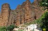
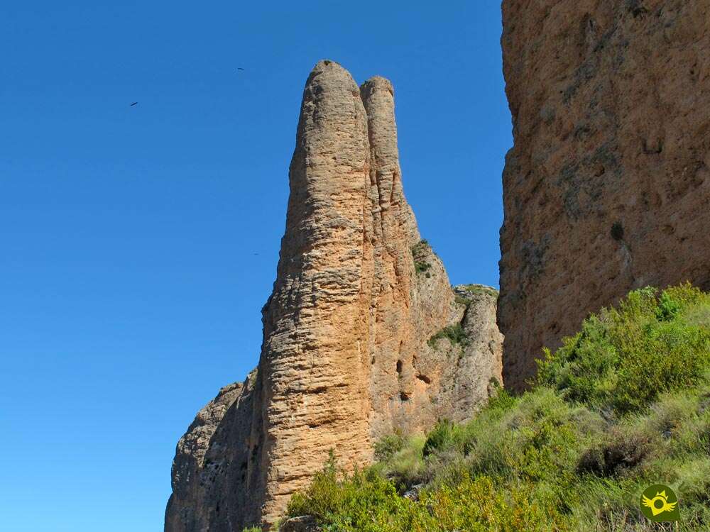
The historic and legendary Kingdom of the Mallos has been and still is part of the history and legend of Aragon. The word "mallos", which is used to define the enormous rocky conglomerate formations that rise hundreds of metres into the sky, often vertically, in the Hoya de Huesca region, has its reference in Riglos. The Turn of the Mallos of Riglos or the Way of the Sky as it is also known, is a circular route that takes us, without the need of being hardened climbers, to conquer these beautiful mountains bathed by the Gállego river, with the permission of vultures and lammergeiers.

The route through the Mallos de Riglos with its 5.2 km starts from the heart of the small town of Riglos, at the foot of the Mallo Pisón, whose unmistakable silhouette stands before our eyes. From here we start to walk this entertaining trekking route that at first forces us to decide the direction in which we want to go. The vertical walls watch us impassively as we scrutinize them in search for the hard-working climbers who try to conquer some of the mythical climbing routes of the many that cross these walls. The Mallo Pisón, the Puro, the Firé are some of the passages we will go through in the first place if we decide to follow the route as the ancient Way to Heaven suggests. The panoramic view of this slope more than compensates for the greater effort involved in venturing through it, taking advantage of the many stops we will make with the excuse of recovering the breath lost in the climb. The Firé pass gives us the option of deviating for a moment to see the lesser-known side of these mountains.

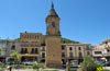
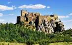
On the way back, we immediately come across another unmissable point on the route, the Viewpoint of the Mallos, an invaluable balcony overlooking the Gállego River, before entering the bowels of the Mallos. The hard ascent comes to an end just as we reach the Viewpoint of Espinable, the highest point of the whole route and a vertiginous terrace with impressive views. The descent or ascent by this other slope of the Mallos of Riglos leads us to let us observe the Colorada Rock while we pass by it. This rock rivals for our attention the Magdalena rock, the imposing Paredón of the Vultures or the silhouette of the Cubillo of Os Fils at whose summit we can sense the Viewpoint of the Vultures. After descending from the bird kingdoms, we leave behind, without hardly being left behind, the Santa Cruz hermitage to head back to Riglos, where we are welcomed by the church of Our Lady of Mallo, whose streets guide us to the point where the circle that forms this Turn of the Mallos of Riglos closes.

Legend has it that many years ago, in a small village, there lived a unique young woman. Singular because of her enormous height that made her the target of the mocking and whispering of all her neighbors. One day, tired of her mockery and enraged by her accusations of witchcraft, the young woman began to pile up huge stones, making a kind of barrier between her house and the rest of the village. Such was the young woman's laborious and tidy work that she soon formed a huge wall several hundred meters high. One after another, enormous mountains were formed, until finally the girl and her house disappeared forever behind the mountains she had created. Even today it is said that on special days the girl leaves the Mallos when she believes that nobody sees her and walks around Riglos contemplating the beautiful place she has created with her own hands.
We arrive at Riglos through the A-132 road that links Huesca with Puente la Reina de Jaca, more specifically it is in the section between Ayerbe and Murillo de Gállego where we will find the detour that will take us to Riglos. Once there, on our arrival, we will find different parking areas until we reach the very doors of the town where the last of them is located, as traffic inside Riglos is restricted to its inhabitants. In this parking area we can find some of the information signs of the different hiking routes in the Hoya de Huesca region that cross the area and from where our route starts.
Important unevenness to which our friend has to face, ideal for those who want to prepare him for greater challenges. Be careful on the cobbled and steep areas of the trail, it is easy to damage a leg.
With no water points except in Riglos, we can not miss their relevant supplies including some food to recover the energy lost in the climb.
Apart from the vultures and other birds that fly over the area, we should not encounter any other animals than the dogs that live in Riglos or those that may be accompanying their owners on the route.
The route is indicated in the car park closest to Riglos (0h 00min), where you will also find several information signs about the different routes in the area.

We continue for a few meters up the road that brought us to the town, reaching its final point where we will have to decide the course to follow. At this crossroads the circle describing the route closes and we will have the opportunity to choose how to travel it.

If we decide on a long, zigzagging climb, although it is gentler in its unevenness, we must pay attention to the marks of the route and follow the street on our right in a strong ascent. If, on the other hand, we decide to follow the recommendations of the old poster explaining the route of the Way of the Sky, we will be faced with a somewhat more demanding and short ascent, thus avoiding having to descend this rough and stony stretch.

As they say, colours are for everyone's taste, we decided to take advantage of the pleasant shade that the Mallo Pisón provides in the mornings to a large part of the route that runs between it and the Mallo Firé. We go into Riglos following the route marked out by the street without any further detours.
.jpg "We're looking for the outskirts of Riglos")
We began a gentle climb that will gradually take us out of the town. Soon we will see ourselves leaving behind the last houses of Riglos and being left alone with the colossal Mallos.

We continue to gain height without too much effort as we walk around the base of the Pisón. The dirt track we walk on brings us closer to the hillside where we have to ascend the mountains.

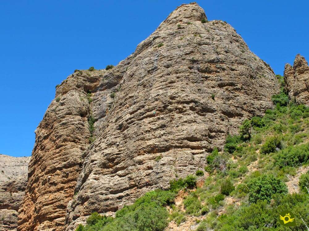
Soon we see ourselves at the foot of the vertical walls whose summit is still hidden from our gaze.

We then begin the real ascent that will take us first to the Firé Pass.

The stony trail describes long curves while leaving behind a number of trails and footpaths that look for the beginning of the different climbing routes.

The ascent under the protection of the Mallos becomes demanding, as if it wanted to encourage us to stop more than usual to contemplate the landscape while we catch our breath.

There are many trails or streams that we encounter and that force us to be aware of the blue marks of the route, to avoid getting into more complicated sections.

In some cases these trails are rejoined with the original path, shortening some distance in exchange, however, for a greater effort and not only for its greater unevenness.

The path alternates sections with quite a few loose stones with others that are somewhat more abrupt, which, together with the slope, make us advance slowly.

Almost without realizing it before us, the Firé pass emerges, at which time we will say goodbye to the PR-HU 98 that continues its course, while we continue with our ascent.

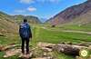
The slope is still demanding but it is compensated by the views we are already beginning to have thanks to the height we are gaining.

After a short while, and without the trail having apparently improved in its changing state, we arrived at the Viewpoint of the Mallos (0h 55min), not without making a detour a few metres to be able to look out over this magnificent balcony.

Once we have enjoyed the show, we will have to resume the ascent that we still have to reach the next objective.

We quickly find ourselves at a crossroads, where a lonely mark on a stone shows us the way to go. It is easy to skip it if we are doing the route in the opposite direction.

The slope gives us a little break just before we have to face the abrupt final stretch of the ascent.

Ahead lies a rocky stretch that looks more like a dry torrent of water.

This area, simpler than it might seem, if it forces us to seek the best route to overcome the obstacles it puts in our way.

The unevenness we overcome in this part of the route is important, warning us of the next end of the ascent.

We continue as before, alternating sections of the trail with others in which the rocks are the protagonists.

Soon we will reach the final ramp of the ascent that will take us to the highest part of the whole route.

A solitary post marks the trail we must follow, shortly before we reach the viewpoint.

From the post we can already contemplate the short distance that separates us from it. The Viewpoint of Espinable (1h 30min) more than compensates the effort required to reach it.

We start the descent leaving on our left the small shelter of Roseta, setting course to the Mallo Colorado.

In front of us, as we start the long descent, we can contemplate in the distance the Viewpoint of the Vultures.

Again we must be careful because we will find some trail that can confuse us, but nothing compared to those we would find if we went down the same route as we went up.

The descent continues its course, beginning to draw some typical curves of the mountain trails.

The state of our path is not in such bad condition, nor is it as cobbled as in the ascent. We even come across sections where the unevenness is not so evident. The route forces us to skirt Colorada Rock while allowing us to advance with some speed.

Again we leave aside one of the many routes that run through these mountains, to continue descending towards Riglos.

Once again the winding trail returns, which will not end until it reaches the path that leads to Riglos.

In one of these curves, next to the enormous wall of the Colorada Rock, we will be able to turn aside a few meters and lean out in search of the Puro that is hidden between the vertical walls.
.jpg "The trail draws wide curves")
The trail goes further and further away from the Colorada Rock, to which we will have to return sooner or later. This part of the descent, whose unevenness is more evident, becomes longer than expected.

We zigzag along the side of the mountain following the direction indicated by the heavy trail, and as in the ascent section we will find trails that lead to the climbing routes of the nearby Mallo.

The trail continues its winding course down the mountainside, making us lose height with every step.

After a long and tiring descent, we come across an old watering hole that indicates the proximity of the end of the trail.

We quickly came across a new crossroads. The GR 1 and the Hoya de Huesca Nature Path welcome us to the end of the route.

A comfortable path that will lead us without further complications to the gates of Riglos.

There will be several paths that will join us in our progress towards the town.

Almost without realizing it, we'll find ourselves traveling around the houses of Riglos.
.jpg "We go down to the road")
The route takes us down the steep street that we left aside at the beginning of the route to make it in this direction.

All that remains is to return along the road to the nearby car park at the entrance to Riglos (2h 10min), where we start the Way of the Sky and finish the Turn of the Mallos of Riglos.
 Distance. 5,2Km
Our starting point will mark the total distance of the route.
 Time. 2:10h
Doing the route in one direction or another should not alter the time needed to travel it too much, although it is true that the better condition of the path that runs through Colorada Rock allows for a faster descent.
 Time of year
The panoramic views offered by the route become much wider if we enjoy good visibility. It goes without saying that with snow or ice, nothing unusual in these lands, the route becomes much more complicated and demanding. Be careful on very hot days or intense sun, we will not have many stretches of shade along the route.
 Required equipment
Although it is not a route with great complications, hiking boots can give us greater stability and protection in the cobbled sections of the path. Without too many areas of shade, water and protection against the sun, a cap, sunglasses and sunscreen, are essential to avoid surprises and bad times, especially in summer. Walking poles, both on the ascent and the descent, can also be good companions. Besides the usual backpack we can not miss the camera or binoculars to the fans of birds. Consult our list of material and equipment for hiking. Read more.
 Difficulty. Medium
Physical
The slope we climb is demanding, so it's best to take it easy, especially if our physical shape is not good. The descent is also not without a certain hardness, either because of its duration or its inclination. Fortunately, the relatively short distance compensates and lowers the level of this route.
Severity of the environment
Without going through too exposed places, the viewpoints are the most aerial points, especially if we want to lean out more than is advisable. The stone falls from the walls of the Mallos are more common than it might seem, fortunately we will transit largely far enough away from them. Be careful on the trails, as well as bumping into some very cobbled and even a little rough or steep sections, in the latter case are usually not steps that represent great complications, we can easily follow trails or streams by mistake and that if they can complicate our lives more than usual.
Orientation
Quite well marked with blue marks and signs at the main crossroads. These are the marks of the other paths that we will coincide with along the route, along with the different trails and streams that we will encounter, which will surely cause us more complications. Curiously, the streets of Riglos are where we will least see the marks of this trekking route, although on the other hand we should not have many doubts.
 |
 |
 |
 |
 |
| 1-Riglos | 0:00h | 637m | 0Km | 30T 687216 4690868 |
| 2-Viewpoint of the Mallos | 0:55h | 898m | 1.6Km | 30T 687226 4691787 |
| 3-Viewpoint of the Espinable | 1:30h | 1038m | 2.3Km | 30T 687531 4691679 |
| 4-Riglos | 2:10h | 637m | 5.2Km | 30T 687216 4690868 |
Coordinates UTM Datum WGS84

 Slope: 810m
 Slope +: 405m
 Slope -: 405m
 Maximum altitude: 1038m
 Minimum altitude: 637m

This sketch of the route is not made to scale nor does it contain all the information relating to the area, it is merely indicative.

![]()
This schematic with the path is approximate and has been created from the derived cartographic base © Instituto Geográfico Nacional "Cuadrante 209-3, 1:25.000"
Senditur has manipulated the tracks to correct the aberrant points that may exist, caused by problems with the reception of the GPS signal. In any case the tracks are always approximate. SENDITUR encourages you to use the new technologies within your reach, using them as support and consultation in your activity, not basing the realization and orientation of the same only and exclusively on them, since they may see their functioning altered by very diverse causes, not functioning correctly and their indications may not be precise.


Los Mallos, que recuerdos!!!

¿Did you know that...
The GR 1 passes through Riglos. This historic long-distance footpath crosses the entire north of the Iberian Peninsula from Ampurias in Catalonia to Finisterre in Galicia, running along the southern slopes of the Pyrenees and the Cantabrian Mountains.
Don't miss out...
The obligatory stopping points that the Trans-Pyrenean Geological Route has on its way through the Mallos de Riglos and Murillo de Gállego. It is a route that consists of 25 stops conditioned at the foot of the road distributed along 200 km of route in Spain and France from which to contemplate places of special beauty and geological value.


From the commitment of SENDITUR with Nature and the respect to the balance of the environment, SENDITUR urges you to travel in a responsible way, with low environmental impact and respecting at all times the Natural, Cultural and Social environment wherever you go.

Besides sharing with all of us your experience on the route we would be grateful if you could write to us to inform us of any erroneous or outdated information you may have found, or simply to let us know what you think at Thank you.
This route has been carried out in the field by SENDITUR on 08-08-2018. The route may vary greatly depending on the time of year, weather conditions and terrain, as well as the actions of third parties and the evolution suffered in the natural environment where it is located. All opinions, advice and/or assessments made by SENDITUR in their descriptions are for guidance only and are subject to and/or refer to the specific conditions of the specific day of the route, referring to that specific day, taken from trained people, with the appropriate experience and with a high level of physical and technical preparation as a reference, as well as correctly equipped.
All the times are approximate and take an orientative character, the stops have not been taken into account, no matter how small they are. All the information related to the route, texts, images, videos, maps, diagrams, tracks, towns, and places of tourist interest are published as a guide, and may not coincide with the current state of each place. Before undertaking any activity, assess your technical knowledge, your physical condition, find out about the weather and the variations that the route may undergo, equip yourself correctly, be prudent and responsible at all times, and do not exceed your capabilities. SENDITUR is not responsible for any misuse or inappropriate use of the comprehensive guides of its routes and/or publications as well as its electronic guides, nor for any variations in their descriptions for the aforementioned reasons, and recommends that everyone be responsible and prudent in carrying out the activity. We also encourage you to read books and specialised guides to complement the information described above.
Continue watching …