Welcome to SENDITUR.COM · paths · routes · tourism

![]() Difficulty-Low
Difficulty-Low
![]() 1:30 h.
1:30 h.
![]() 4.7 km.
4.7 km.
![]() Difficulty-Low
Difficulty-Low
![]() 1:30 h.
1:30 h.
![]() 4.7 km.
4.7 km.
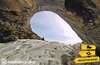
Not far from Cervera del Pisuerga, in the heart of Mountain Palentina, awaits us one of those lords of the forest that have been watching us for centuries, treasuring history and legends in almost equal parts. On the hillside of Mount San Cristóbal, bathed by the waters of the Requejada reservoir, the Roblón de Estalaya has been growing for hundreds of years, 800 according to official data. This majestic grandfather of the forest of singular size, more than 12 metres high and between 11 metres of trunk at the base and 9 metres in the central area, is surely the longest-lived and largest in the Mountain Palentina. The Roblón de Estalaya Path leads to it, a simple route that allows us to visit this grandfather and enjoy the landscape and hiking in the Mountain Palentina.
To reach the starting point of the Roblón de Estalaya Path, follow the road that links Cervera de Pisuerga with Potes and Puentenansa. Not far from Cervera de Pisuerga, at the Requejada reservoir after crossing the village of Vañes, we will find the turning that leads to Estalaya and shortly after passing the crossroads that leads to this town, the parking area awaits us from where this beautiful hiking route begins.
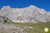
The parking area next to the road that leads to the town of San Felices de Castillería is our starting point for this route that will take us to the Roblón de Estalaya. An information sign explains some of the singularities that we are going to find, as well as marking the beginning of the route. The route follows the marks of the PR-P4 and the conditioned path along which it runs. We quickly cross the Castillería stream before it flows into the nearby reservoir.
We follow the course of this stream and almost immediately come to a fork.
Here we follow the path to our left, leaving aside the path by which we will return. Little by little we approach the dense forest where grandfather lives. The slope is noticeable at every step, but for the moment it is not a big problem. Shortly after entering the forest, a small shelter awaits us, inviting us to take a break, knowing what awaits us ahead. After the stop, we resume our walk, arriving almost without noticing it, at a new fork. Here we follow the path to the left, facing the steep slopes that separate us from our objective. After the effort we are rewarded with the reward of the Roblón de Estalaya (0h 40min), a specimen of sessile oak (Quercus petraea) that is impressive to look at.
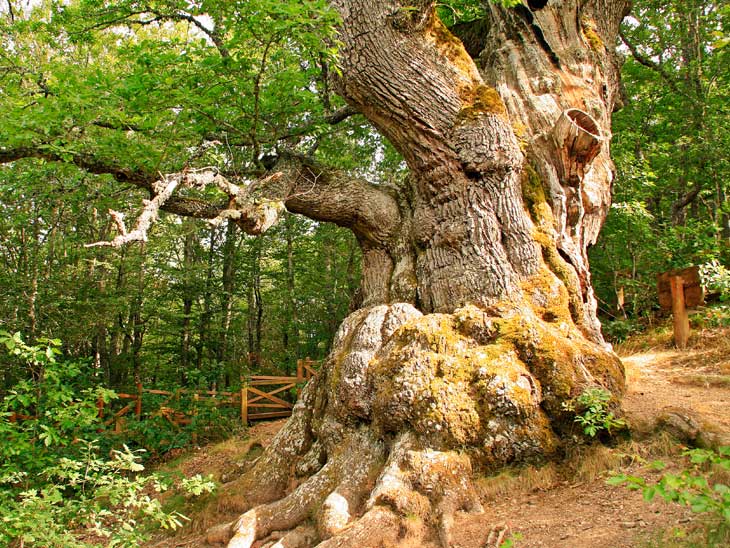 The Roblón-CC/Miguel Ángel García
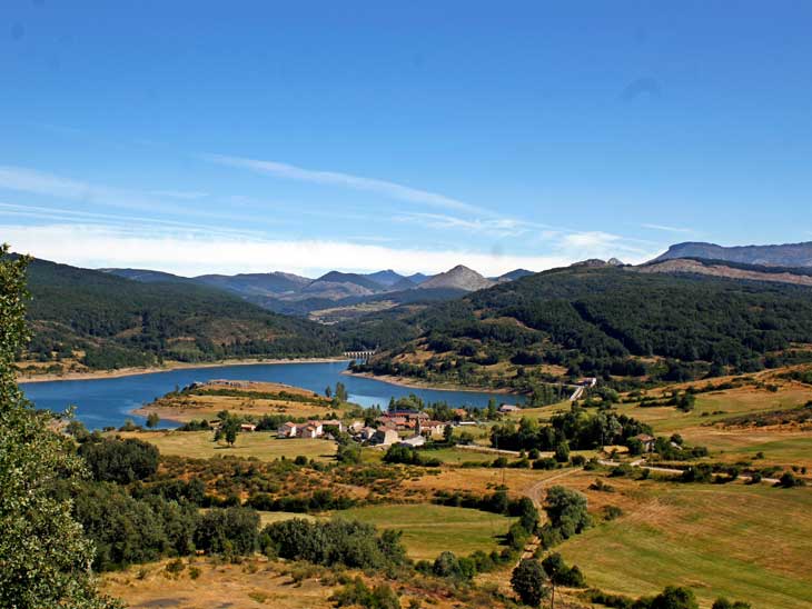
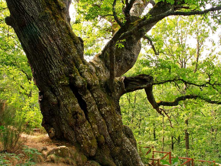
The Roblón-CC/Miguel Ángel García

Once we have enjoyed this emblematic grandfather of the forest, we will return to the starting point. We can do so by following the steps that brought us here, or also by extending this route a little to get even more out of this area of the Mountain Palentina. To do so, at the fork that brought us to El Roblón, we follow the marks that lead us towards the reservoir and the nearby village of Vañes. The forest continues to accompany us, giving way to a beautiful beech forest. Little by little we descend until we leave the forest that protected us from the sun. After leaving behind a watering place, we reach a new crossroads from where we can enjoy a beautiful view of Vañes and the Requejada reservoir. At this point our route coincides with the GR 1 markings that will accompany us on this part of the route. This route takes us along the edge of the reservoir, going up the arm that enters the Castillería valley. After a while we reach the fork that we passed at the beginning of the route, from where we only have to walk the stretch of path that separates us from the parking area (1h 30min) from where we start the Path of El Roblón.
1-The parking lot is not very big so it fills up quickly, so it is advisable to get up early.
2-Although the official start of the Path of Roblón is at the parking lot, you can also start either in the village of Estalaya or in the village of Vañes.
3-This is a simple route but you should still equip yourself properly, bearing in mind that you are at an altitude of over 1000m.
4-Grandpa is sure to be delighted with your visit, but remember to be respectful of him and the rest of the local flora and fauna.
 |
 |
 |
 |
 |
| 1-Parking | 0:00h | 1080m | 0Km | 30T 379875 4753448 |
| 2-Roblón de Estalaya | 0:40h | 1220m | 1,75Km | 30T 379456 4752533 |
Coordinates UTM Datúm WGS84

.png) Distance: 4,7Km
Distance: 4,7Km
.png) Time: 1:30h
Time: 1:30h
.png) Difficulty: Low
Difficulty: Low
 Slope: 370m
 Slope +185m
 Slope -185m
 Maximum altitude: 1230m
 Minimum altitude: 1075m

![]()
This schematic with the path is approximate and has been created from the derived cartographic base © Instituto Geográfico Nacional "Cuadrante 107-1 y 107-3 1:25.000".

¿Did you know that...
This area of the Mountain Palentina is inhabited by the brown bear. It will probably be very difficult to see them, but you never know.
Don't miss out...
A visit to the villages in the area, Estalaya, Vañes and San Felices de Castillería are examples of the typical architecture that characterises the villages in this part of the Mountain Palentina.


From the commitment of SENDITUR with Nature and the respect to the balance of the environment, SENDITUR urges you to travel in a responsible way, with low environmental impact and respecting at all times the Natural, Cultural and Social environment wherever you go.

Besides sharing with all of us your experience on the route we would be grateful if you could write to us to inform us of any erroneous or outdated information you may have found, or simply to let us know what you think at Thank you.
Route information updated on 03-06-2021. The route may vary greatly depending on the time of year, weather conditions and terrain, as well as the actions of third parties and the evolution suffered in the natural environment where it is located. All opinions, advice and/or assessments made by SENDITUR in their descriptions are for guidance only and are subject to and/or refer to the specific conditions of the specific day of the route, referring to that specific day, taken from trained people, with the appropriate experience and with a high level of physical and technical preparation as a reference, as well as correctly equipped.
All the times are approximate and take an orientative character, the stops have not been taken into account, no matter how small they are. All the information related to the route, texts, images, videos, maps, diagrams, tracks, towns, and places of tourist interest are published as a guide, and may not coincide with the current state of each place. Before undertaking any activity, assess your technical knowledge, your physical condition, find out about the weather and the variations that the route may undergo, equip yourself correctly, be prudent and responsible at all times, and do not exceed your capabilities. SENDITUR is not responsible for any misuse or inappropriate use of the comprehensive guides of its routes and/or publications as well as its electronic guides, nor for any variations in their descriptions for the aforementioned reasons, and recommends that everyone be responsible and prudent in carrying out the activity. We also encourage you to read books and specialised guides to complement the information described above.
Continue watching …