Welcome to SENDITUR.COM · paths · routes · tourism
Stage 04b Route of the Hospitals
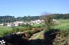
Borres, Principado de Asturias![]()
![]()
![]()
![]()
![]() (1)
(1)
Following in the footsteps of the ancient pilgrims
![]() Difficulty-Remarkable
Difficulty-Remarkable
![]() 4:05 h.
4:05 h.
![]() 13.8 km.
13.8 km.
Borres, Principado de Asturias![]()
![]()
![]()
![]()
![]() (1)
(1)
Following in the footsteps of the ancient pilgrims
![]() Difficulty-Remarkable
Difficulty-Remarkable
![]() 4:05 h.
4:05 h.
![]() 13.8 km.
13.8 km.
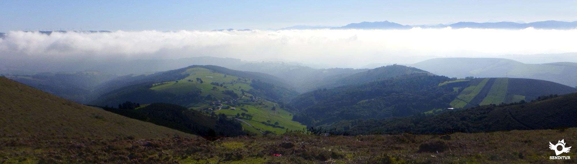
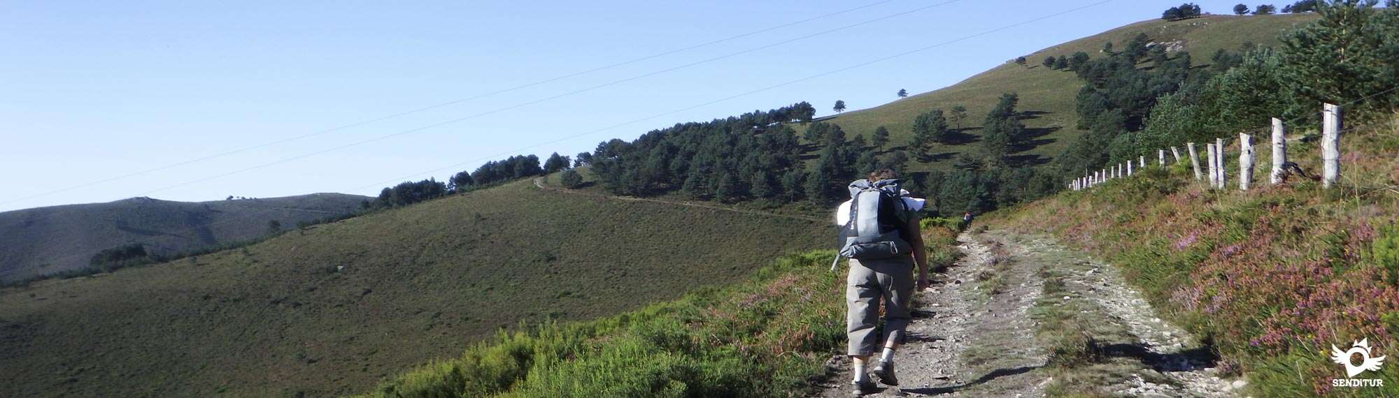
The mountain range of Fonfaraón is the incomparable frame by where it passes the Route of the Hospitals that from the vicinities of Borres and Samblismo transports us of mountain in mountain until the Pass of El Palo where it converges with the pilgrims that up to here arrive coming from Pola de Allande. A stage of the Primitive Way that crosses the historical route that followed the old Roman road that went up to the mines of the mountains and that later, as in many cases it happened, they were transformed into jacobeas routes that took the pilgrims towards Santiago.

Stage 4b Route of the Hospitals with 13.8 km leads us through the mountains visiting the remains of ancient hospitals that in the late Middle Ages served as refuge and aid to pilgrims who passed through here. A route that departs from the vicinity of Borres, where we find perfectly signposted the detour of the Route of the Hospitals and that in a first moment seems to resist to separate from its sister that leads towards Pola de Allande, route that began to follow from the foundation, around the year 1225, of this locality. Samblismo, a little far from the route or La Mortera, which we slip past next to its small chapel of San Pascual, are the last towns with which we will hardly have contact before facing many kilometres at the mercy of the wind and the inclemency of the weather, as we cross the solitary mountains that separate us from the first urban nucleus that we have to find, having already descended in part the Pass of El Palo.

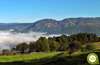
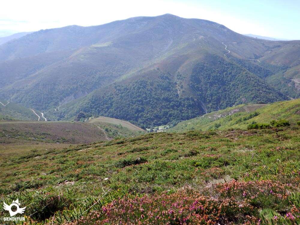
From La Mortera begins a hard ascent that will take us to cut the skirt of the mountain, gaining meters of height with each step that we give, enjoying that yes of the magnificent landscapes that this route is offering to us. Already above 1000 m of altitude we find the first ruins, those of the Paradiella Hospital. The relative short distance that separates the different hospitals that this mountain lodges speaks to us well of the rigors that here suffered and suffers the pilgrim to cross these mountains, especially in winter or with bad weather. Its orientation, the unpopulated slopes and the terrain chosen by the path that seeks once up to take a profile as light as possible, leave us at the mercy of the elements but also offers magnificent views of the valleys and mountains that surround us. Green hills between mountains, constant ascents and gentle descents is what awaits us, while we visit another of the remains that hardly resists the passage of time the Fonfaraón Hospital, from where we will already have at our feet the valley through which passes the stage that brings the pilgrims who leave Pola de Allende to the Pass of El Palo.

The path leads us bordering the rounded mountains, crossing the pastures where the abundant cattle that meet here graze, up to the Valparaiso Hospital. Soon the route takes us to crown the Pass of the Marta, to undertake from there the final stretch of the route, a new ascent that will take us to the Freita Hospital, and to the same Roman mines of gold that left their imposing imprint in all our route and especially in La Fana la Freita, a spectacular cut in the mountain originated by the action of the Roman mining. From here and observed at all times by our objective, we undertake the gentle descent that will take us to the Pass of El Palo, where this route ends and where we will meet again with the Way of Saint James that climbs from Pola de Allande to continue together towards La Mesa.
All pilgrims have to choose between taking this route or following the normal Way, not being few who are left with the desire to have also been able to make the discarded route. Those pilgrims with the necessary strength and time have the possibility of following the stage from Tineo to Pola de Allande, where they can arrange a transport service that will take them back to Borres to follow the Route of the Hospitals, picking them up later at the Port of Palo to take them down to Pola de Allende, where the next day they will return to the Primitive Way, having taken them just one more day to the total of the necessary ones.
Slope, kilometres, lack of water, heat and few shady spots in summer, a large number of factors that will undoubtedly make this stage a tough test for our friend. It is true that unlike the rest of the stages this one is far from asphalt and traffic, but we will also be a long way from any civilized point. Be very careful if we venture to make the route in fog, it is tremendously simple that our friend is absent-minded and does not succeed in finding us.
In this stage we are obliged more than ever to bring enough water and food because we do not find places where you can drink or places to buy something to eat. The few water points are frequented by cattle and are not very recommendable for this very reason.
The cattle are at ease, so it is not uncommon to find horses, cows, etc.. in virtually all the route, so we will have to be attentive so that our companion does not bother them.
A little more than 1 km separates Borres from the detour of the Route of the Hospitals (0h 00min) where this stage begins leaving behind the itinerary that leads to Pola de Allande.
.jpg "We leave the Way to Pola de Allande and we begin the Route of the Hospitals")
We advance gaining height with smoothness without anything, except the mountains in front of us, makes us intuit what awaits us.

The itinerary progresses for now almost in parallel with the Way to Pola de Allande that runs to our left, where we can also see the town of Samblismo, which we would have passed if we had followed the other route. We can still enjoy the shade offered by the wooded sections we cross, a shade that we will surely miss later in the summer days.

The now comfortable path allows us to advance without major complications leaving behind some path that comes to meet us.

Our path leads us to an asphalt track which we follow for a few meters until we find another dirt road.

We quickly reached this dirt road where we must continue our steps towards the nearby village through which we are about to pass.

Without further delay the road leads us to the first house of La Mortera (0h 20min), which we will barely touch, as it extends to our left as we pass next to it. We head towards the chapel of San Pascual, and after passing it, we finally leave La Mortera and prepare ourselves to face the real beginning of the dreaded ascent that awaits us.

It is from this place where the two itineraries that the Primitive Way offers to the step by these lands and that ran to barely separated by the road, they separate definitively setting each one course to their respective objectives.

Almost at the moment of passing by the chapel, on our left begins a steep track where we have to continue.

Quickly the asphalt track becomes a wide dirt track that continues to make us gain height quickly, letting us sense the magnificent landscapes that we are going to find in this stage.

The wide track, perfectly delimited, barely gives us a break while it makes us leave the valley at our feet and faces us towards the mountains that we are going to ascend.

There are not many paths that we come across, this added to the signage and the best condition of our track will not have problems for the time being to follow the route.

We continue ascending with our eyes set on the mountains that extend to our left.

What looks like a water tank marks the junction where we have to divert, taking the path on our left that makes us cross a gate that prevents the passage of livestock.

We continue ascending embedded between the fence that delimits the way while we cut the slope of the mountain. The slope that we are saving gives us some hard ramp, demanding a greater effort than we are already doing.

The valley rushes to our feet while our way gives us a small not very lasting truce that serves to us to be able to enjoy the views that from here we have. Again we return to the crude reality and we continue to gain height with each step at the same time that we observe the thin line that traces the way cutting the hillside.

From the valley ascends a track that joins us for together, continue ascending in search of the hill that separates the two mountains that we have next to us. Finally it seems near the end of this first ascent and the beginning of a somewhat more benevolent stretch with us.

The path crosses the pass making us undertake a gentle descent with the mountain now on our left hand, while we watch as the marked track extends in front of us, leading us to the next mountains we will cross.

This mountain range at the mercy of inclement weather, was the place chosen a few years ago to locate the Paradiella Hospital (1h 45min) that awaits us in the next pass through which we pass.

Several paths converge on this high plateau beaten by the winds. Luckily, the row of stakes begins and every few metres they indicate the direction to follow, especially useful in case the fog covers the landscape around us.

If this is not the case, we will be able to easily observe the path to follow which, as it could not be otherwise, after passing between two formidable and solitary pines, undertakes a hard ramp that climbs up the foothills of the mountain.

We begin the steep ascent following a broken and cobbled path while leaving on our left how many paths lead to the paths that run further down.

This hard stretch makes us quickly gain the height necessary to win the shoulder of the peak Hospital on whose hillside awaits us another of the milestones of this stage. The slope softens allowing us to catch our breath, leading us to a group of trees where one of the typical landmarks of the Way indicates the direction to follow.

Also from now on we will have the useful small posts indicating us the route at each step, since in many stretches the way is blurred giving the impression that we are walking across the field.

The route leads us along the soft shoulder of the mountain following the small wooden posts that, like breadcrumbs, mark out the route to follow.

We continue ascending as if the path wanted us to today climb the top of the mountain as a reward for the effort made.

But nothing could be further from the truth, since after a while a solitary milestone diverts us, making us cut the slope of the mountain without reaching its summit. We skirt the rounded top of the mountain following the marked path that leads us to the gates of another valley.

To our right we can see the silhouette of a mountain towards which we are heading, and the marked path that cuts it hillside. But before reaching it we are surprised by the ruins of the Fonfaraón Hospital (2h 30min) which gives its name to the mountain range we are visiting.

We pass by the stone wall that delimits the old hospital to go towards a new ascent that awaits us later. Luckily, the path only borders the Hospital Peak, thus freeing us from the considerable unevenness that we would have had to assume if we had climbed it.

To our left we can see the valley through which runs the stage that ascends from Pola de Allande to the Pass of El Palo, where we go.

After a while we find ourselves with a new fork in the road, here is the option on the left which we must continue to face a pleasant and comfortable stretch that has nothing to do with the hard ramps that we have been leaving behind.

This stretch, continuously marked once again by wooden posts, continues to make us cross the slope of the mountain giving us beautiful views.

The ruins of the Valparaiso Hospital (2h 50min) go almost unnoticed covered by the bushes and trees that grow on them. We continue the course that marks our way in his tireless journey through these mountains.

The undulating path takes us to a wide pass where we find a solitary lagoon that we leave to our right to continue the almost rectilinear course that takes us to the rounded mountain in front of us.

The route takes us once again along the hillside of the mountain, without making us ascend to its summit, while we contemplate the following mountains towards which we are heading.

We begin a quick descent with our eyes set on the road that, on our left, slowly seems to approach us.

Before we meet her we will see ourselves in the middle of a battle of signs where some will tell us to go straight on and others that we turn to the left, down the hillside, which is where we must go. Otherwise, a little further on, some new marks will indicate that we have to turn off, taking a trail that joins us with the right option.

Once we have taken this first detour, we descend without any further delay to the road. When we reach it, on its left margin, we will have a battered andadero where we can ascend the stretch that separates us from Pass of the Marta (3h 15min).

The cobbled path leads us to border, on the right, the mountain in front of us, which is marked by what looks like a small shelter. This section demands a greater effort to make us gain height going up the slope of the mountain without giving us a moment of respite.

We leave behind us the hut that marks out the peak that we have just bordered to face a more comfortable section crossing a plateau that extends in front of us.

In front of us a path that if followed would take us to a steep cut of the mountain known as La Fana la Freita. We continue with the pleasant terrain that we are crossing. This place we are passing by is where the old Freita Hospital was located, of which only a few stones remain that remind us of its existence.

We advance with our eyes fixed on a group of buildings that seem to belong to a wind power plant, whose imposing mills populate the mountains in front of us.

This clearly more marked stretch of path continues in a gentle descent, with each step approaching the Primitive Way itinerary that comes from Pola de Allande.

The small posts that guided us in many sections of this stage are the ones in charge of leading us to a great high tension tower that marks our arrival at Pass of El Palo (4h 05min).

Here we will unite with the pilgrims who took the other alternative to together undertake the dizzying descent ahead of us.
 Distance. 13.8Km
To this figure we have to add both the distance to get to the start of the route and the distance that separates us from the end, at the pass, with the town where we finish the stage.
 Time. 4:05h
This time is only for this route, so we must add the necessary time to complete the stage, both to reach the beginning of the route and to finish from the Pass of El Palo to where we decide to conclude the walk.
 Time of year
Even being well signposted, bad weather, wind or fog can play a trick on us and not only harden the stage further but also be able to lose us very easily. In addition, one of the main attractions of this route are the magnificent panoramic views that it offers and what better way to enjoy them than on clear days when the landscape extends as far as the eye can see. It goes without saying that with snow and unless we are equipped with the necessary material and experience, essential in the winter mountain, the idea of taking this route of the hospitals should not even cross our minds.
 Material required
We are in front of a route in which we will be many kilometers without having the services that in other stages give us, as far as food and liquids are concerned. Furthermore, if we add to this their physical demands and the marked mountain characteristic of the route, it results in a stage in which we must more than ever be forward-thinking and correctly equipped. Food and water, the mobile with the battery charged to the maximum and if possible the GPS with the track of the route, which together with the map of the area are objects that we should carry in our rucksack. The walking sticks will undoubtedly be of great help and the cap, with sunglasses and sunscreen can not miss us because we will barely have shade. As for clothes and footwear, they are also conditioned to the terrain on which we will walk, a trekking boot and some warm clothing even being summer will surely be something we will be grateful for in many moments of the stage. Consult our list of material and equipment to make the Way. Read more
 Difficulty. Remarkable
Physical
We are in front of a quite demanding stage in the physical thing, given the slope that we must overcome. We also have to include the sections that bring us both from the starting point and to the place where we end the day. This fact adds one more step to the degree of difficulty, adding an additional category. The final point of the stage is the one that will force us to make a greater effort both in kilometres and in unevenness even though this is negative, so the pilgrims who decide to take on this route have to be aware of their possibilities and not underestimate this stage.
Caution
This section is perhaps the one that will cause us the least complications, as long as we do not leave the marked route and always bearing in mind that we are in a mountainous terrain, changing and in some areas with no clear roads to follow. As for the rest, except for some more cobbled areas than normal and as long as we don't find mud or ice, nothing strange at certain times of the year, we wouldn't have to have any more complications. It is the weather, with its strong winds or the thick fog, which will undoubtedly affect us the most.
Orientation
Aware of the extreme weather conditions that can be found in this route the pilgrim, the association of friends of the Primitive Way has perfectly marked out the entire route, adding to the already typical marks that we come carrying a row of small wooden posts that every little distance indicate the route to follow. A system that is appreciated at all times, especially when the path loses its presence and we have to advance across the field. Even so, the fog is a real problem if it makes an act of presence since it can become so thick that we cannot see the next post. It is not strange that the fog suddenly surprises us rising quickly from the valley or arriving almost without warning from the other mountains due to the strong winds that whip these peaks. Of course, if the terrain is snowy, the marks will disappear as they are not high and we will see ourselves doing a navigation exercise reserved for people with experience in this type of cases.
 |
 |
 |
 |
 |
| 1-Detour Route of the Hospitals | 0:00h | 714m | 0Km | 29T 697340 4800239 |
| 2-La Mortera | 0:20h | 728m | 1.5Km | 29T 696026 4799792 |
| 3-Paradiella Hospital | 1:45h | 1008m | 5.4Km | 29T 693324 4797967 |
| 4-Hospital de Fonfaraón | 2:30h | 1200m | 7.5Km | 29T 691677 4796894 |
| 5-Valparaiso Hospital | 2:50h | 1169m | 9.1Km | 29T 690304 4797273 |
| 6-Pass of the Marta | 3:15h | 1118m | 11Km | 29T 688930 4796255 |
| 7-The Freita Hospital | 3:40h | 1205m | 12.1Km | 29T 688630 4795262 |
| 8-Pass of El Palo | 4:05h | 1147m | 13.8Km | 29T 688390 4793714 |
Coordinates UTM Datum WGS84

 Slope: 1036m
 Slope + 734m
 Slope -: 302m
 Maximum altitude: 1225m
 Minimum altitude: 714m

This sketch of the route is not made to scale nor does it contain all the information relating to the area, it is merely indicative.

![]()
This schematic with the path is approximate and has been created from the derived cartographic base © Instituto Geográfico Nacional "Cuadrante 050, 1:50.000"
Senditur has manipulated the tracks to correct the aberrant points that may exist, caused by problems with the reception of the GPS signal. In any case they are always approximate. SENDITUR encourages you to use the new technologies within your reach, using them as support and consultation in your activity, not basing the realization and orientation of the same only and exclusively on them, since they may see their functioning altered by very diverse causes, not functioning correctly and their indications may not be precise.


Un recorrido duro pero satisfactorio, me gusto mucho. Aquí un compañero que me encontré en el camino.

A magical place of legends and mystery

Find out what to see in...
¿Did you know that...
The Roman mining industry has left a large number of footprints in the mountains and valleys that cross this route, to the impressive deforestation of Freita we can add the lagoons where cattle graze now and that in the past served as containers where to accumulate the water that was later used for the extraction of the precious mineral, or the pipelines that were used to transport that water to the mining exploitations and that now go unnoticed seeming more battered roads than they really were in their day.
Don't miss out...
The Roman gold mines of La Fana la Freita, almost at the end of the route a small detour, which later returns us to the Way, will bring us closer to a wooded area just at the limit of this spectacular cut made in the mountain, by the once flourishing mining industry of the Romans who used their ingenious systems to extract the precious material, such as the Ruina Montium or Arrugia and which consisted literally of making entire mountains fall by injecting them with water under pressure, and then extracting the veins of gold.


From the commitment of SENDITUR with Nature and the respect to the balance of the environment, SENDITUR urges you to travel in a responsible way, with low environmental impact and respecting at all times the Natural, Cultural and Social environment wherever you go.

Besides sharing with all of us your experience on the route we would be grateful if you could write to us to inform us of any erroneous or outdated information you may have found, or simply to let us know what you think at Thank you.
This route has been carried out in the field by SENDITUR on 15-11-2018. The route may vary greatly depending on the time of year, weather conditions and terrain, as well as the actions of third parties and the evolution suffered in the natural environment where it is located. All opinions, advice and/or assessments made by SENDITUR in their descriptions are for guidance only and are subject to and/or refer to the specific conditions of the specific day of the route, referring to that specific day, taken from trained people, with the appropriate experience and with a high level of physical and technical preparation as a reference, as well as correctly equipped.
All the times are approximate and take an orientative character, the stops have not been taken into account, no matter how small they are. All the information related to the route, texts, images, videos, maps, diagrams, tracks, towns, and places of tourist interest are published as a guide, and may not coincide with the current state of each place. Before undertaking any activity, assess your technical knowledge, your physical condition, find out about the weather and the variations that the route may undergo, equip yourself correctly, be prudent and responsible at all times, and do not exceed your capabilities. SENDITUR is not responsible for any misuse or inappropriate use of the comprehensive guides of its routes and/or publications as well as its electronic guides, nor for any variations in their descriptions for the aforementioned reasons, and recommends that everyone be responsible and prudent in carrying out the activity. We also encourage you to read books and specialised guides to complement the information described above.
Continue watching …
 Previous: Stage 4 Tineo-Pola de Allande
 Next: Stage 5 Pola de Allande-La Mesa