Welcome to SENDITUR.COM · paths · routes · tourism


Stage 06 La Mesa-Grandas de Salime
La Mesa, Principado de Asturias![]()
![]()
![]()
![]()
![]() (1)
(1)
A toboggan of imposing dimensions
![]() Difficulty-Moderate
Difficulty-Moderate
![]() 4:40 h.
4:40 h.
![]() 15.8 km.
15.8 km.
La Mesa, Principado de Asturias![]()
![]()
![]()
![]()
![]() (1)
(1)
A toboggan of imposing dimensions
![]() Difficulty-Moderate
Difficulty-Moderate
![]() 4:40 h.
4:40 h.
![]() 15.8 km.
15.8 km.
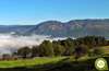
The deep breccia of the valley of the river Navia cuts, as if it were butter, the mountains through which this stage that joins La Mesa with Grandas de Salime runs. A rugged gorge today flooded by the waters of the reservoir that is undoubtedly one of the protagonists of the day. A route that will take us, following the route of the Way of Saint James, from the mountains, at more than 1100 m of altitude, to precipitate us in a crazy and convoluted descent that will lead us to the deepest part of the valley that is located to scarce 200 m on the level of the sea. The spectacular landscapes give way to lush forests where chestnut trees, beeches and a large number of native species will entertain us a more demanding journey than expected.

Stage 6 La Mesa-Grandas de Salime of the Primitive Way with 15,8 Km starts from the small village of La Mesa, where we will say goodbye to its pleasant location to face, without time to prepare ourselves, to a hard ascent that will make us climb to the mountain of Coriscos or Buspol crossing its hillside, thus avoiding us to crown its summit populated with wind mills. The small Chapel of Santa Marian de Buspol awaits us, from where we undertake the vertiginous descent towards the basin of the Navia River. A route that will allow us to enjoy the magnificent views that it offers, where we will be able to scrutinize the itinerary of later stages, at the same time that we imagine already in Grandas de Salime, even more distant from what it wants us to believe. A descent that, as well as making us lose height, introduces us into a dense forest where we will have the first moments of shade in which we can refresh ourselves on hot summer days.

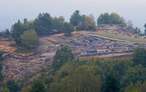
The reservoir towards which we are heading engulfed under its waters a good number of villages, among which was Salime, where one of the paths we left behind descends, where on rare occasions we could find a boat that crossed us on the other side of the reservoir. The deceptive route, as if it were a real roller coaster, forces us to go up the mountain by an instate to quickly throw us down the hillside through a winding path that leads us directly to the meeting with the road. A road that will be in charge of guiding us almost in its totality and not without effort until Grandas de Salime. The imposing dam that became the second largest in Europe awaits us later, but before crossing it we cannot resist entering the viewpoint that its own architect designed for the delight of own and strangers. We leave behind the remarkable work of engineering to undertake the long ascent that separates us from the end of the stage. Vistalegre, or rather the buildings that composed it, tell us about the workers who lived here while the pharaonic works were carried out.

In front of us, the long stretch of road continues to force us to make an effort to move forward as we leave with each step further down the reservoir that extends as far as we can see. Knowing that the road, if we follow it, would take us to the Grandas de Salime itself, we are hesitant to do so and follow its risky course or take the steep path where the route continues, bidding us farewell to the asphalt. This path makes us overcome some hard ramps at the beginning, fortunately soon gives way and gives us as a reward for the effort made a nice route to the very gates of the town, where our stage ends. We cross the Grandas stream and enter Grandas de Salime, where its important ethnographic museum awaits us or the church of El Salvador, whose origins date back to the 12th century, where we conclude this stage.
Legend has it that many years ago, when the river Navia ran impetuously through the steep gorge that had formed between the mountains that enclosed it and people spoke of how rugged and beautiful these landscapes were, the devil himself could not help but come to visit them. Surprised by its beauty, he did not hesitate to underestimate this singular place, with no better idea than to jump from cliff to cliff over the river making fun of all those who were there, with such bad luck that he slipped when stepping on a wet rock and rushed into the river where the force of the current took him. Hardly the devil managed to cling to some bushes and climb up to the shore where those who were there said that he could barely hear insistent babbling the phrase ... Eh logrado salime! Eh logrado salime! Eh logrado salime! and hence this region is known by the name of Salime.
A complicated route that can cause our companion more problems than expected, in the form of injuries generated by the accumulation of kilometres endured to date added to the long and demanding descent he has to face. Moreover, we will not be able to avoid the long stretches of road or the cobbled paths that this stage forces us to travel. For the rest, if we stick to the distance, we are in front of a relatively comfortable stage where only his profile should put our friend in trouble.
Without water points or places where we can replenish supplies we are facing a stage that forces us if or whether to bring enough food and water to face the route with solvency even though temperatures are not as high as in summer.
Except in the first part of the route where we will coincide with the cattle and the dogs that live in the localities of the stage we should not cross with more animals. Ojo we must not forget that we are in the middle of nature and that this area is famous for the fauna that inhabits it, although the normal thing is that they keep a lot from letting themselves be seen.
The same road where we arrived yesterday, next to the church of La Mesa (0h 00min) give the starting signal to this stage 6 La Mesa-Grandas de Salime.

As it was already clear to us the day before, we were faced with an important ascent as soon as we started, and it would be better to take it easy. The marks of the GR together with those of the way serve as reference to us to know which of the roads we should take.

The hard ascent, quite demanding and long, follows at all times the line that marks the road making us gain height with each step at the same time that brings us closer to the huge mills that we previously saw so far away. We ascend cutting the hillside of the mountain looking for the way to save it without having to crown its top.

The hard ascent arrives to its end leaving us in a wide plain in which we can contemplate what surrounds us with all clarity, mountains and green meadows only altered by the mills and the enormous electric towers.

The route now allows us to catch our breath in complete tranquillity, while we continue advancing on the abrasive asphalt and without any unevenness and even beginning to lose some height but for now very gently.

For the moment we follow the road, without deviating from the paths we are on.

After starting a more evident descent, in the middle of a curve, we find ourselves in front of us with the path that we must continue leaving the road.

Vegetation envelops the entrance to the path, quickly turning it into a narrow trail. The footpath goes through the enclosure of the farm that together with the chapel of Santa Marina form Buspol (0h 50min).

From here we have little left to get fully into what will be the intense descent that will take us to the reservoir of Salime.

We advance along a battered trail embedded between a slate wall that in return offers magnificent views of the environment that surrounds us. The trail meets a gate which we have to cross, just to cross it follow on the left practically bordering the fence that marked our way here.

After a few metres you will come to a wide path on your left. The Primitive Way then begins the descent through it and continues to make us border the wall that accompanies us from Buspol.

From here we can already observe the town of Grandas de Salime towards which we are heading and part of the route that we will cross next to the reservoir.

The descent, noticeably more accentuated, forces our path to meander along the hillside in an attempt to soften the unevenness we are facing.

The fence that we were bordering is already on our back while we continue losing height following the steep path composed of loose stone, firm that makes us go down with the necessary prudence to avoid slips and falls.

The path zigzags along the slope of the mountain approaching and moving away from the reservoir, rarely we find a path or another, but as usual the vegetation is responsible for showing us clearly which is the path to follow.

Our footpath comes to an end when we suddenly come across a wide and somewhat wrecked road that we must continue to descend.

This path, which looks like a firewall, continues to make us lose height with each step, not without caution especially if the ground is wet.

At the same time that we lose height the tree-lined one is gaining protagonism offering us the appreciated shade that in the days of summer surely we are missing.

The generous descent maintains its incessant course taking us from side to side of the hillside without yet offering us a moment of rest.

After a vertiginous descent we arrived at the crossroads where in the past we were offered the option of descending directly to the shore of the reservoir to cross it by boat, freeing us from part of the route in exchange for an important effort to descend and later recover the lost height.

The not-so-secure presence of the boat and the abrupt profile to be saved have left this shortcut in disuse. From here we will be surprised by a change of trend in our path.

Luckily or unfortunately we have a small climb that precedes an undulating stretch that takes us cutting the wall of the mountain.

This part of the route makes us doubt the correctness of our march since it seems to insist on moving away from the swamp at the same time that it makes us recover some height.

But nothing could be further from the truth, since after a long time cutting the wall of the mountain we arrived at the moment to abandon our way and turn radically to follow a narrow trail that rushes through the lush forest.

The narrow trail poses a strong and winding descent through the interior of the forest.

Turns and more turns that lead us irremediably to the encounter with the road after crossing the slope that borders it, where we will be joined by the cyclists who followed their course in Berducedo.

A long and dangerous stretch of road awaits us in front of us, which in the first instance brings us closer to the dam of the reservoir.

The Way crosses the dam of the Salime reservoir to undertake the ascent towards the locality that gives it its name. We follow at all times the course of the road that leaves the dam behind and begins to gain height leaving the reservoir again at our feet.

The road takes us to cross what remains of the town of Vistalegre (3h 00min) while continuing with its convoluted layout gaining meters to the slope of the mountain.

Sometimes a narrow trail allows us to put between the traffic and us the guardrail, but in most cases ends up forcing us to jump when we meet suddenly with the end of the trail.

The long road itinerary gives us little respite. While the reservoir is lower and lower.

The few footpaths or paths we come across do not create any doubt about the path to follow, as the road will be our companion almost until the end of the stage.

We leave behind a crossroads with another road to continue with the ascent embedded between stone walls that still give us less room for manoeuvre with the vehicles that pass through here.

Luckily we find the detour that will take us from the asphalt, avoiding the piece of road that separates us from Grandas de Salime and that cyclists must follow. Once taken the detour we begin a short but very steep ascent, reason why many pilgrims prefer to play the type and follow the road.

Although it is true that the ramp is very intense, and that if it is with mud it is even more demanding, with enough patience we will save the short stretch with greater slope and we will avoid the dangerous road. The trail climbs very quickly, snaking again and getting directly into the forest.

Luckily after a short time the trail loses its great intensity and allows us to climb something more comfortable.

The trail runs half way up the hillside and is not in very good condition, especially if it has rained, so we must be careful to avoid stumbling over the roots that populate the road or skidding over the slabs that protrude from the ground.

The trail takes us through a thick forest towards the town where the stage ends, whose first buildings can already be seen among the trees. We begin the small descent that will take us to the road we had left before.

The trail, which has now become a well-kept walk, takes us directly to the road at the very gates of the town.

A few metres further on we have the street that crosses the river and introduces us to the town.

We cross the river to continue the route that takes us into the town and which takes us past the ethnographic museum.

The street we enter leads directly to the municipality of Grandas de Salime (4h 40min) and a few meters ahead the church of San Salvador de Grandas where this stage ends.
 Distance. 15.8Km
If we do the last section by road this figure will hardly increase.
 Time. 4:40h
Although it might seem that being a great part of the downhill stage should take much less time, at least as a general rule we are faced with an uncomfortable route that will not let us advance quickly given its unevenness and also provide us with hard ramps that will slow down our progress.
 Time of year
This stage combines high-altitude pastures from which we can delight ourselves with the magnificent panoramic views they offer, with lush forests that will surround us with their trees and shrubs. Undoubtedly one of the attractions of the stage is the Salime reservoir, its state can offer us spectacular prints like the one that is given when draining the excess water dammed in it. Winter can also offer us beautiful panoramic views, but the harshness of these lands almost makes their postcards exclusive images reserved for the inhabitants of this area.
 Material required
Although on the descent, cobbled and slippery, good boots that offer grip and stability are appreciated, on the long stretches of road we will be more comfortable with shoes that unload our feet and help us keep the boot for more propitious terrain. The walking sticks will undoubtedly be good allies both on the descents and on the hard ramps we will face, nor is it a bad idea to equip ourselves, for the journeys on the asphalt, with reflective clothing or objects that help us to be seen. The thermal differences in this stage are even more evident if it is possible to find a few degrees of variation between the valley and the mountain, eye even the reverse of what was expected. For all these reasons we must be forward-thinking and know the weather forecast to adapt our clothes and equipment not only to the weather conditions of each time of year but also to the special circumstances that we may find here. Consult our list of material and equipment to make the Way. Read more
 Difficulty. Moderate
Physical
Coming from the stages that we come from, this might seem like little given its mileage, but nothing further from reality, we are facing a demanding stage not only physically but also muscularly, in which it is relatively easy to injure ourselves due to the load of kilometers and efforts that we carry. There are strong slopes waiting for us, both negative and positive, which will not give us a moment of respite. It is true that the relative short distance contributes to be able to take this stage with a certain calm, if we need it, lowering the level that it would otherwise have.
Caution
The cobbled and slippery ramps next to the road journeys are the greatest dangers that we are going to find, always, of course, that we do not leave the marked route and the conditions of the terrain and the meteorology are appropriate. Snow, and above all mud and ice, which we can undoubtedly find at certain times of the year, considerably increase the difficulty of the route, forcing us to equip ourselves with the appropriate material to help us progress safely in these circumstances. Watch out for dry leaves, wet tree roots and gravel in certain areas, it is better to use a few minutes more than to lament falls or slips. Of course it goes without saying that as we pass through the dam we must respect safety guidelines and common sense. Do not trust the apparent calm on the road, the constant curves do not allow much visibility to drivers and pilgrims, reaching us suddenly without having noticed their arrival.
Orientation
We continue to coincide with the signposting of the GR that complements that of the Way, even so at the beginning of the descent if we run into the fog we may have problems following the course of the itinerary. The paths that we follow, well marked in comparison with those that come out on their way, and the road, make following the Primitive Way in this area generally simpler. The entrance to Grandas de Salime is the one that can give us more problems because the marks are not so easy to see or even disappear and we must follow in any case the common sense that leads us to the center of the population.
 |
 |
 |
 |
 |
| 1-La Mesa | 0:00h | 869m | 0Km | 29T 678392 4787387 |
| 2-Buspol | 0:50h | 980m | 2.3Km | 29T 676899 4788086 |
| 3-Vistalegre | 3:00h | 260m | 10.4Km | 29T 674402 4789087 |
| 4-Grandas de Salime | 4:40h | 560m | 15.8Km | 29T 672505 4787177 |
Coordinates UTM Datum WGS84

 Slope: 1815m
 Slope +: 753m
 Slope -: 1062m
 Maximum altitude: 1040m
 Minimum altitude: 240m

This sketch of the route is not made to scale nor does it contain all the information relating to the area, it is merely indicative.

![]()
This schematic with the path is approximate and has been created from the derived cartographic base © Instituto Geográfico Nacional "Cuadrante 050, 049, 1:50.000"
Senditur has manipulated the tracks to correct the aberrant points that may exist, caused by problems with the reception of the GPS signal. In any case they are always approximate. SENDITUR encourages you to use the new technologies within your reach, using them as support and consultation in your activity, not basing the realization and orientation of the same only and exclusively on them, since they may see their functioning altered by very diverse causes, not functioning correctly and their indications may not be precise.


Para mi una de las más bonitas de todo el Camino Primitivo

Find out what to see in...
¿Did you know that...
The dam of the Salime reservoir reaches a little more than 125 m of altitude, the reservoir was completed there in 1954 and its waters flooded a large number of villages that settled around the gorge where the river Navia ran. The works on the dam have left traces of the work carried out in the area, such as, for example, the buildings that housed the workers who worked there and which formed part of what is now known as the old town of Vistalegre.
Don't miss out...
The viewpoints of the dam and the Salime reservoir that you will find along the road. The first, before reaching the dam, will take you into a sort of anti-aircraft shelter from which you can contemplate the dam and the flow of the river after its passage through the reservoir. The second most obvious will give you a perspective of the reservoir and the mountains you have just crossed.


From the commitment of SENDITUR with Nature and the respect to the balance of the environment, SENDITUR urges you to travel in a responsible way, with low environmental impact and respecting at all times the Natural, Cultural and Social environment wherever you go.

Besides sharing with all of us your experience on the route we would be grateful if you could write to us to inform us of any erroneous or outdated information you may have found, or simply to let us know what you think at Thank you.
This route has been carried out in the field by SENDITUR on 17-11-2018. The route may vary greatly depending on the time of year, weather conditions and terrain, as well as the actions of third parties and the evolution suffered in the natural environment where it is located. All opinions, advice and/or assessments made by SENDITUR in their descriptions are for guidance only and are subject to and/or refer to the specific conditions of the specific day of the route, referring to that specific day, taken from trained people, with the appropriate experience and with a high level of physical and technical preparation as a reference, as well as correctly equipped.
All the times are approximate and take an orientative character, the stops have not been taken into account, no matter how small they are. All the information related to the route, texts, images, videos, maps, diagrams, tracks, towns, and places of tourist interest are published as a guide, and may not coincide with the current state of each place. Before undertaking any activity, assess your technical knowledge, your physical condition, find out about the weather and the variations that the route may undergo, equip yourself correctly, be prudent and responsible at all times, and do not exceed your capabilities. SENDITUR is not responsible for any misuse or inappropriate use of the comprehensive guides of its routes and/or publications as well as its electronic guides, nor for any variations in their descriptions for the aforementioned reasons, and recommends that everyone be responsible and prudent in carrying out the activity. We also encourage you to read books and specialised guides to complement the information described above.
Continue watching …


 Previous: Stage 5 Pola de Allande-La Mesa
 Next: Stage 7 Grandas de Salime-A Fonsagrada