Welcome to SENDITUR.COM · paths · routes · tourism
![]() Difficulty-Low
Difficulty-Low
![]() 1:15 h.
1:15 h.
![]() 3.8 km.
3.8 km.
![]() Difficulty-Low
Difficulty-Low
![]() 1:15 h.
1:15 h.
![]() 3.8 km.
3.8 km.
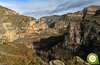
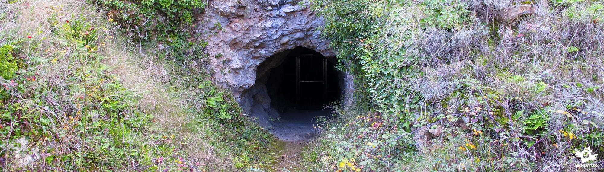
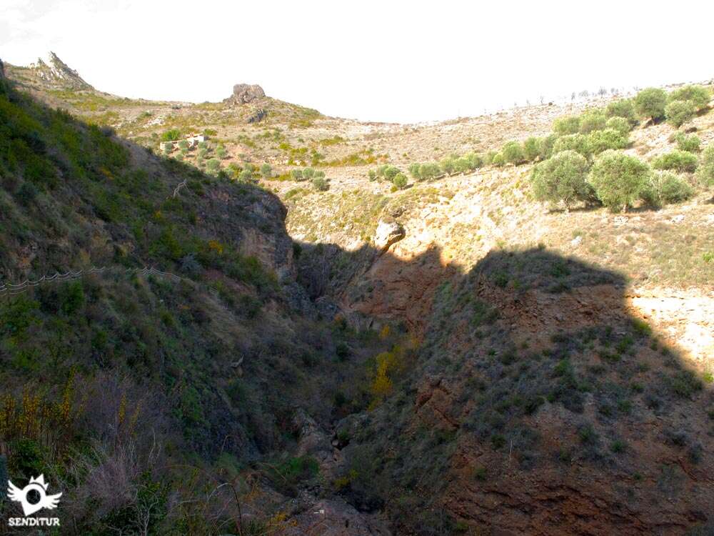
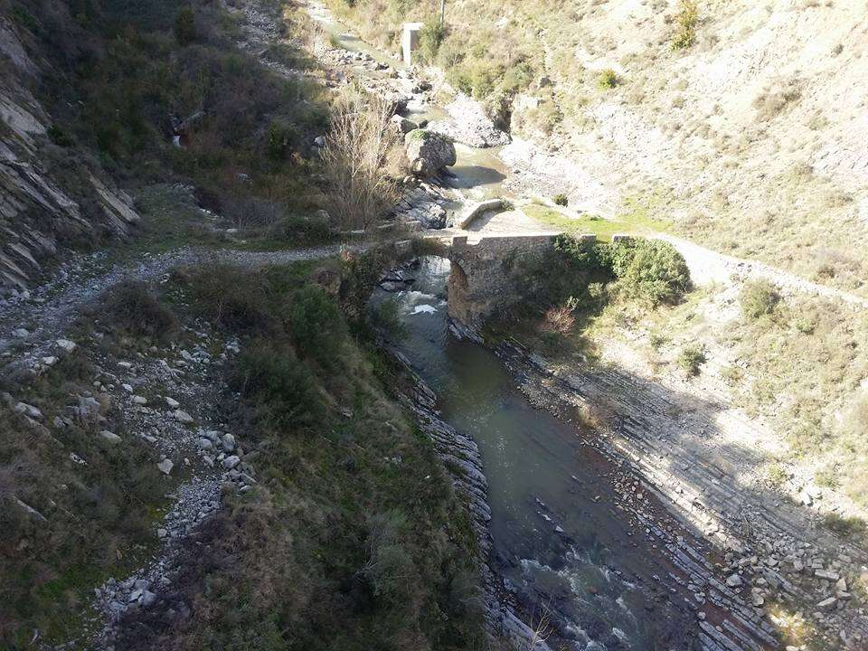
In the narrow ravine of the San Martín River, a tributary of the Jubera, natural border between the towns of Jubera and Santa Engracia de Jubera, the ancient lead mines of Jubera await us. The special characteristics of these lands added to the hand of the man have given form to a landscaping set of great beauty, where to be able to put us in the skin of the hardened miners who deepened in the entrails of the mountain. The 3.8 km route starts from Jubera and follows the Route of the Jubera Towns, descending towards the road that brought us to this Riojan locality, in search of the dirt track that leads to the nearby mines. No doubt a few meters before taking the detour and crossing the bridge over the river that allows us to reach Jubera, we will have seen, when arriving at the town with our vehicle, this path and the sign indicating Jubera Mines.

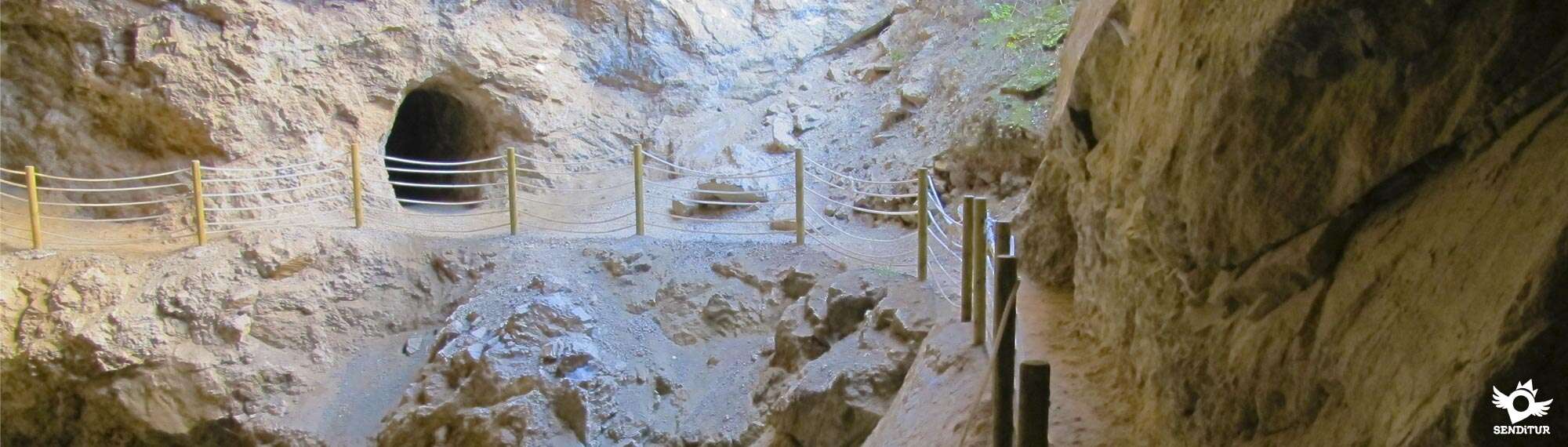
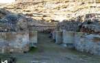
Ascending through it and without deviating from the main track at any time, we will pass by the hermitage of the Virgen del Prado and, just after, we will walk towards the ravine of the San Martín river. This route allows us to enjoy beautiful panoramic views of the Jubera valley, observed by the castle that defended these lands. Already in the surroundings of the mine we can turn aside and ascend a short stretch towards a hidden mine mouth in the hillside of the mountain. After saying goodbye to this corner, all that remains is to walk the few metres that separate us from the site occupied by the different buildings that formed part of the mining complex, at this point is the oldest tunnel in the mine. The mines of Jubera or Tunnels of the Moors, as they were known, were active from 1945 to 1958, bringing to the region a large number of inhabitants who came not only from nearby towns but also from the rest of Spain.

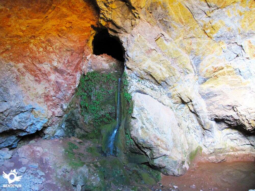
Previously, around the year 1785, the first estimates were made which did not give the expected results. It was in 1945 when, after some new tests, it was decided to start with the exploitations. From this main area we can continue to enter the ravine, which gradually narrows, and leaving to our left the trail that climbs the mountain and corresponds to the route of the villages, we descend to the tunnel where is the Fountain of the Moros Tunnels, located in another of the mining areas.

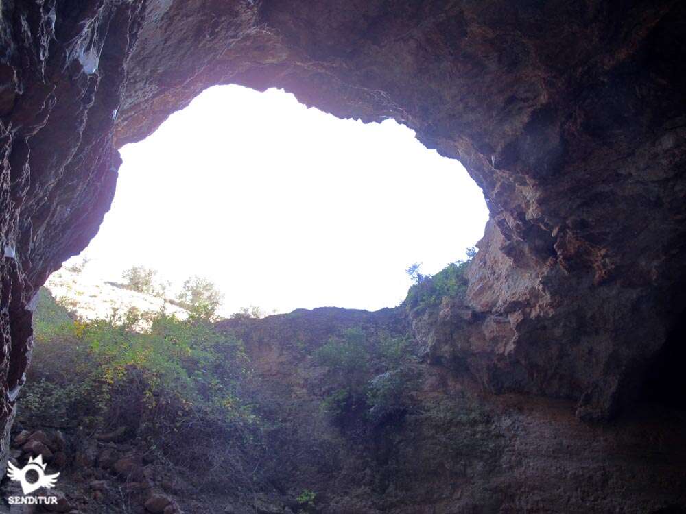
This fountain is actually an aquifer or spring formed by the waters of the San Martín River, filtered in the upper part of the mountain and which, finding the least permeable materials, looks for a way to continue its course, coming out again to the light to rejoin the channel it had left behind. In this place the most adventurous will be able to enter a long and dark gallery that will make them feel like the skin of the hard-working miners. From here we will return following our footsteps to the beautiful town of Jubera.
According to the inhabitants of the region, Venturiel was a village that existed in this area, whose inhabitants all died poisoned by the waters they brought to it from the nearby Santa Engracia. Apparently a salamander fell at a great banquet of which the inhabitants of the village were going to eat, dying and thus disappearing Venturiel.
From Murillo de río Leza, which can be reached via the LR-259 from Logroño, passing through Villamediana de Iregua or by taking the detour on the N-232 at Agoncillo, take the LR-261 that crosses Ventas Blancas and reaches the access to Jubera. A few metres before reaching the detour that leads to Jubera we will see the path, signposted by a sign indicating the detour that leads to the mines of Jubera. This dirt track would allow us to reach them with our vehicle, but it is advisable to continue until Jubera and leave our vehicle there. The narrowness of the track and its sometimes somewhat muddy state, together with the fact that we would miss part of the panoramic views offered by the route, make it preferable to cover the scarce 4 km that the itinerary has on foot. From Jubera, where at the end of the entrance road to the town we will find a large square to leave our vehicle, this route will return us to the nearby road following the road that led us from him to Jubera, to travel to the mines.
Entertaining and simple route, in which we will be able to verify the courage of our friend when exposing him to tunnels in complete darkness.
The road is the most complicated area, although it doesn't usually support much traffic. We will not have water points except in Jubera, but the short distance of the journey makes this should not be a problem, even so in summer we should not lack the water in our backpack. The source of the tunnels is a torrent of water that can not be accessed, so we should not confuse its name. In the same place it is also possible to descend to the riverbed, which is usually dry, and at this point there is a pond, but with retained water.
At the beginning of the track we will pass next to a recreational property and an agricultural pavilion where scandalous guard dogs will come out to meet us, which are normally inside the fenced enclosure.
 Distance. 3,8Km
Our starting point will determine the distance to be covered.
 Time. 1:15h
This is the time it will take us to complete the entire route, not counting the time we spend travelling throug:the different areas proposed in the mines. If we dare to climb up to the castle we will have to have about 30 minutes more round trip.
 Time of year
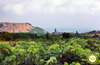
The conditions of luminosity together wit:the meteorological ones, are the ones that should guide us in our decision to visit the mines. A good luminosity is of good help if we lack flashlights or headlamps. The flow of the San Martín river and the rains will also condition the state of the fountain. For the rest the landscape offers us a wide range of colors depending on the time of the year, ranging from white almond trees that are added to the colorful flowers in spring to the ochres and yellows of autumn. The proximity of the mountains makes winter a time wit:its particular beauty, althoug:wit:less certainty as far as time is concerned.
 Required equipment
We can not miss a headlamp or a flashlight, the photo camera and in summer the canteen wit:water, in addition to clothing and sports shoes according to the time of year and the weather, is all we need. Consult our list of material and equipment for hiking. Read more.
 Difficulty. Low
Physical
Without great difficulties, the short ramps that we will find at the beginning and at the end of the route, allow us to face them calmly and do not suppose great efforts. The short distance of the route allows us to take it wit:the necessary calm and time to face this walk.
Severity of the environment
A comfortable and pleasant track, together wit:some conditioned paths and equipped wit:ropes that serve as a handrail in the steepest areas, make the route a simple walk. We do not have to leave the marked or enclosed areas that guide the visit, as this is still an area where mining work was carried out and the thick undergrowt:can hide some cavity. The short stretc:of road, althoug:without muc:traffic, is still another area to be attentive.
Orientation
Clearly marked by the white and orange signs that delimit the route of the Route of the Villages of the Jubera, these are the marks that at the beginning and end of the route should not confuse us because if we follow them would lead us along this route, instead of the Fountain of the Tunnels of the Moors or the square of Jubera. In addition, the layout of the track and the road should avoid any possible confusion.
 |
 |
 |
 |
 |
| 1-Jubera | 0:00h | 655m | 0Km | 30T 558368 4683436 |
| 2-Hermitage of the Virgen del Prado | 0:20h | 650m | 1Km | 30T 558112 4684126 |
| 3-Lead Mines | 0:40h | 645m | 1.9Km | 30T 557639 4684412 |
| 4-Hermitage of the Virgen del Prado | 1:00h | 650m | 2.8Km | 30T 558112 4684128 |
| 5-Jubera | 1:15h | 655m | 3.8Km | 30T 558368 4683436 |
Coordinates UTM Datum WGS84

 Slope: 326m
 Slope +: 163m
 Slope -: 163m
 Maximum altitude: 655m
 Minimum altitude: 640m

This sketc:of the route is not made to scale nor does it contain all the information relating to the area, it is merely indicative.

![]()
This schematic wit:the pat:is approximate and has been created from the derived cartographic base © Instituto Geográfico Nacional "Cuadrante 242-2 1:25.000".
Senditur has manipulated the tracks to correct the aberrant points that may exist, caused by problems wit:the reception of the GPS signal. In any case the tracks are always approximate. SENDITUR encourages you to use the new technologies within your reach, using them as support and consultation in your activity, not basing the realization and orientation of the same only and exclusively on them, since they may see their functioning altered by very diverse causes, not functioning correctly and their indications may not be precise.


Ctra. Ventas Blancas S/N
941432372

Find out what to see in...
¿Did you know that...
At the top of the San Martín ravine, very close to the village of the same name, is one of the Icnitas archaeological sites in La Rioja. It has the traces of carnivorous and herbivorous dinosaurs, having the peculiarity of being the second place in La Rioja where a new type of Icnitas has been discovered, baptised as Hadrosaurichnoides Igeensis in honour of its first appearance in Igea.
Don't miss out...
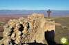
The magnificent views that can be enjoyed from the Castle of Jubera. From Jubera square starts the path that not without effort will take us to the top of the hill where the ruins of this historic castle are located.


From the commitment of SENDITUR with Nature and the respect to the balance of the environment, SENDITUR urges you to travel in a responsible way, with low environmental impact and respecting at all times the Natural, Cultural and Social environment wherever you go.

Besides sharing with all of us your experience on the route we would be grateful if you could write to us to inform us of any erroneous or outdated information you may have found, or simply to let us know what you think at Thank you.
This route has been carried out in the field by SENDITUR on 15-06-2016. The route may vary greatly depending on the time of year, weather conditions and terrain, as well as the actions of third parties and the evolution suffered in the natural environment where it is located. All opinions, advice and/or assessments made by SENDITUR in their descriptions are for guidance only and are subject to and/or refer to the specific conditions of the specific day of the route, referring to that specific day, taken from trained people, with the appropriate experience and with a high level of physical and technical preparation as a reference, as well as correctly equipped.
All the times are approximate and take an orientative character, the stops have not been taken into account, no matter how small they are. All the information related to the route, texts, images, videos, maps, diagrams, tracks, towns, and places of tourist interest are published as a guide, and may not coincide with the current state of each place. Before undertaking any activity, assess your technical knowledge, your physical condition, find out about the weather and the variations that the route may undergo, equip yourself correctly, be prudent and responsible at all times, and do not exceed your capabilities. SENDITUR is not responsible for any misuse or inappropriate use of the comprehensive guides of its routes and/or publications as well as its electronic guides, nor for any variations in their descriptions for the aforementioned reasons, and recommends that everyone be responsible and prudent in carrying out the activity. We also encourage you to read books and specialised guides to complement the information described above.
Continue watching …


.jpg "Go to Estate of Ribavellosa")
.jpg "Go to Monastery of Suso")