Welcome to SENDITUR.COM · paths · routes · tourism


GR 190 Section 3 Viniegra de Abajo-Villoslada de Cameros
Viniegra de Abajo, La Rioja![]()
![]()
![]()
![]()
![]() (1)
(1)
A walk from the Urbión River to the Sierra Cebollera Natural Park
![]() Difficulty-Remarkable
Difficulty-Remarkable
![]() 6:55 h.
6:55 h.
![]() 24.3 km.
24.3 km.
Viniegra de Abajo, La Rioja![]()
![]()
![]()
![]()
![]() (1)
(1)
A walk from the Urbión River to the Sierra Cebollera Natural Park
![]() Difficulty-Remarkable
Difficulty-Remarkable
![]() 6:55 h.
6:55 h.
![]() 24.3 km.
24.3 km.
This section of the GR 190, that of The High Valleys Iberian, can be found in the foothills of the Sierra Cebollera Natural Park, along the old paths that link the towns of Viniegra de Abajo, Ventrosa de la Sierra and Brieva de Cameros with Villoslada de Cameros. Rounded hills, wide meadows and steep ravines form the landscape of a land linked for years to transhumance. On the way we will find part of the rich history of the people who inhabited these places and who left their mark in many different ways, legends, steles, milestones...

This GR 190 section 3 Viniegra de Abajo-Villoslada de Cameros, of 24.3 km, takes us along the path that from the old town of Viniegra de Abajo, with its unique buildings, leads to Ventrosa, crossing the beautiful landscape where this town is marked by its unique Clock Tower, which is visible from almost anywhere in the valley. From Ventrosa the path goes along the bottom of the valley until it starts to climb the hill, where we will find El Palo, a stone landmark that indicated ancient boundaries. From here we can enjoy impressive views and intuit the path that lies ahead of us to Canto Hincado. The descent through the ravine between pastures and kermes oak groves will take us to Brieva de Cameros, a town closely linked to transhumance.

The town has a spectacular viewpoint from which we can enjoy unbeatable views of the surrounding environment. From Brieva, the route goes up the river Berrinche towards the Peaks of The Stairs, where it starts to climb the famous Stairs, towards the Pass of Canto Hincado where it meets the link with the GR 93 that comes from the nearby Ortigosa de Cameros. From the pass, the route heads towards the Sierra Cebollera Natural Park, where it meets the Roman Stela on the San Cristóbal hill, a tombstone with Celtiberian and Roman inscriptions from the 2nd and 3rd centuries AD.

To then start the descent through the Maguillo ravine until you reach the entrance of the last town on the route, where you will find another link on the GR 93 that goes from the El Hoyo hermitage to Villoslada de Cameros and its Royal Loom Factory.
According to the legend, the stone monolith known as El Palo, was nailed centuries ago in the pass of the same name between Ventrosa and Brieva de Cameros, to mark the separation between the two villages due to a pest that devastated the area.
To reach Viniegra de Abajo we must take the LR-333 which, crossing the town, joins the LR-113 between Nájera and Salas de los Infantes with the N-111 between Logroño and Soria, also passing through Viniegra de Arriba, Montenegro de Cameros and Villoslada de Cameros. There is a regular bus service that makes the Logroño-Canales de La Sierra route with a stop, according to the timetable, either in Viniegra de Abajo or at the junction with Venta de Viniegra. Once there, in the middle of the road at the entrance of the Venta Viniegra, after crossing the bridge and before reaching the school building, we will find a small wooded area with some benches, just at the beginning of the street where the GR continues.
This is a hard stage for our companion, to the great distance covered we have to add the important unevenness and the scarcity of shady areas where to cool down.
We go through a livestock area so we will meet the cattle, although the most committed are the shepherd dogs that accompany the herds, where they will also come out to meet us, it is when passing by the livestock pavilions of Ventrosa and Brieva de Cameros. In addition, at the entrance of Villoslada we will pass by a kennel, although this is usually closed.
Without shade and with a considerable distance between the water points, it forces us to pay special attention to the water we carry and to replenish it in the towns and fountains where we pass.
A few metres after entering Viniegra de Abajo (0h 00min), following the road that crosses the town as we enter from the Venta of Goyo, we find a small square with some benches and next to it the street that, on the left, goes up through the town centre.

We continue straight on this street that ends in a square with a cross in the middle, just in front of us on the left, begins the hard ascent ramp that through a street first and then through a cement track will take us out of Viniegra.

Continuing the hard ascent along this track, leaving behind as many options as possible, we arrive at the GR detour. On turning the last cement curve of this track, we come across the cemetery in front of us, and a few metres before this, next to the gap between the guardrail, the footpath where the route continues.

This footpath that goes through a ravine to jump to the other side, continues to level out parallel to the cement track, passing by the cemetery that is a few meters above us, to turn left, to go in search of the hill that when we were ascending the track, we saw on our left.

Just when the direction of the walk changes, the footpath, which is somewhat broken, begins the ascent again to overcome this hill. At this point the cattle has drawn an endless number of paths, although the main one is well defined, we can have as a reference the electricity poles.

At the top of the hill, when you reach the first light post, the path turns a little to the right to find the old road to Ventrosa.

From here to this town the itinerary becomes totally smooth, becoming a pleasant path through the interior of a thick forest, from which we leave just to contemplate the beautiful panorama that Ventrosa forms and the valley where it is situated.

At the entrance of this town we pass by a hermitage and through some metal doors, we arrive at Ventrosa (0h 50min) through a bridge.

We turn to the right and in that same hand we leave a fountain, where we can take water, since it will be a route where the shade is scarce, in front of us a parking lot, and to our left the wide street, with trees on its sides, that we must follow and that leads us to leave Ventrosa in search of the old road of Brieva that little by little will make us leave this beautiful town behind.

At the exit of the village on our left side, next to a light pole we will see a sign with the direction indicators towards Viniegra de Abajo and Villoslada.

We pass by some livestock pavilions and follow the dirt track without leaving it, accompanied by some incipient trees surrounded by some protections. Portable metal structures that seem to be used to attend to the livestock also dot this part of the road.

A parking lot marked for hunters is located on our right, a little further on we ignore a path that comes out to our right and we continue to move forward, as we are ascending. We reach a point where the marks on the path indicate that we should leave the track and continue on the left, we do so, but we quickly rejoin the track that we previously had, coming to the conclusion that the only thing the marks wanted was to save us a curve in the road.

Without leaving the track at any time we are gradually approaching the entrance to the ravine, where another very important reference, which marks the right direction, is the power line that will not leave us until the next village.

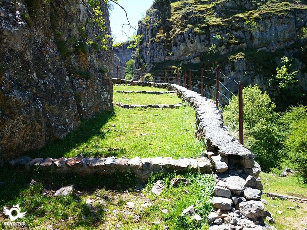
We go along the bottom of the valley and when we see a rock with a large hole on the left we leave the ravine, turning right and start a half-slope climb along a footpath. This point is marked with a GR indication with a turn to the right. As we zigzag upwards, if we turn, we see the path we have brought winding through the ravine and in front of the hole we mentioned earlier, we can see how an old stone fence was hidden.

The trail gains width quickly, becoming a path, which little by little in an upward direction will lead us to a hill, where the path disappears when we meet a meadow. As we descend, if we look and turn slightly to the right, we will see El Palo, a stone monolith that stands out on the plain because of its height. Seeing the Canto Hincado pass in the distance, we begin our descent, leaving El Palo on our left and seeing a high voltage tower in the background, we head towards it, which leads us to the entrance of the Brieva valley.

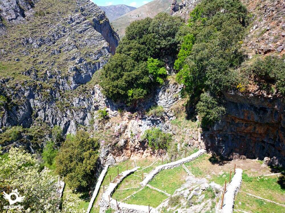
The descent begins on the right side of the valley, along a footpath that makes a wide curve that changes to the left side of the valley, crossing under the power line, approximately halfway down the slope begins a more pronounced zigzag descent, with the firm of this part with much loose stone, becoming at some points, slippery and with vegetation.

We hear the sound of water announcing our arrival at the bottom of the ravine as we walk through a kermes oak grove leaving the ravine on the right, the path widens passing through scattered trees leaving small paths on the right side. In the distance we can sense what seems to be the Brieva cemetery, two watering holes, without water, one of which is in ruins, greet us as we walk.

The path at this point, with an almost flat profile and covered with grass is blurred in the meadow, advancing a little further, you can see part of the tower of some church.

The path turns into a cement track along which we advance a few tens of metres until a well-marked footpath appears on the right where the remains of stone from what must have been a gateway to a fence. We walk a few metres along the footpath and then go back to the cement track, which we ignore to avoid a bend.

The church of Santa María, where we must turn right, welcomes us to the Barruso neighbourhood. We advance, leaving the river on the left until we reach a bridge that crosses it and gives access to the road, turning right at this point and continuing along the road we reach Brieva de Cameros (2h 40min), which we will cross to continue our journey.

Little by little we go up the road, leaving on the right a stone cross, a park with its stone fence, the pelota court, the detour to the source of the river Brieva and so on until we leave the village. On the last wide dirt track just before the start of the road's guardrail, where you can see two cattle sheds on your right, the GR continues.

Without abandoning it, we advance until we reach the place where we can see a fountain and a path to our left, which is the one we should take.

The path ascends parallel to the river, gradually becoming a footpath that enters the gorge, until it reaches the section known as The Stairs, where through some closed zigzags in the form of steps we quickly gain height.

Taking this way height, we continue for a footpath that little by little moves us away from the ravine, we pass between two demolished constructions to then turn to the left for a footpath and to continue ascending doing some curves, now long, that take us to a zone of pastures.

We must head, following a path surrounded by bushes that can only be guessed at, towards a refuge that can be seen from a distance on the left.

Crossing a track, we arrive at the refuge The House of the Mine, where stuck in its wall there is a fountain-trough, leaving it to the left we follow our way, and without losing the direction we continue ascending until arriving at the Pass of Canto Hincado (4h 20min), where the footpath leaves to a dirt track with the road to our left.

At this point, if we look to our left we will see a large vertical stone that marks the boundary between Ortigosa and Villoslada. In this area you can link up with the GR 93, but we must go to the right, along the track, towards Villoslada by the GR 190.

The ascent becomes gentler and we continue along the track for several kilometres, until we reach a hill, where on our left we see a gate in the shape of a staircase that we must cross by entering a pasture.

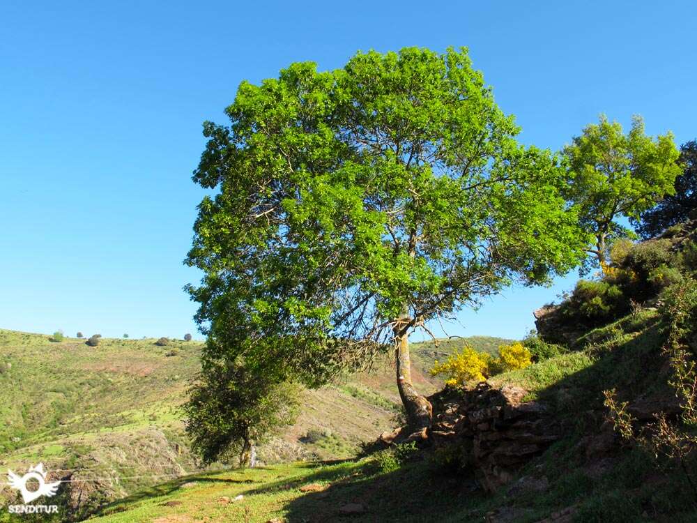
We leave on our right a wire fence from which we gradually separate, a solitary tree in the middle of the esplanade can serve as a reference to see where we should direct our steps, leaving the tree on our right separating us from it.

A well marked trail begins that enters a wooded area that does not last long, as we go out to another pasture where we must try to continue at the same height and not lose the trail that is well marked by the footprints of people. We enter another pine wood and when we leave it we reach another pasture, here we must go straight on leaving a group of four or six trees, which seem to be grouped in a circle on the right, little by little we must go to the left, going almost to the slope or hill where the path is to be followed.

We walk halfway up the slope to the entrance of a pine grove where there is a watering hole with a fountain, now the trail goes a little bit upwards and leads us to a staircase shaped gate that we cross, entering the Sierra de Cebollera Natural Park.

We head, with spectacular views, towards a hill which we win, and after it, descend until we reach a track where we must turn left. Coming in the opposite direction, we have to be very careful not to skip this crossing, which is escorted on the right by a pine tree and where there are remains of a GR sign.

Now this track, in smooth ascent, we must not leave it at any moment until arriving at a hill where several ways converge, after crossing a fence we must follow by its left side that will guide us already in descending sense by the place of San Cristóbal until the Roman Stela (6h 10min) of Villoslada.

We descend following the fence until we are forced to cross it, coinciding with a bush-shaped tree that hides the fence from us, to now leave it to our left.

We separate from the fence and go towards the hill, which is located in front of us and invites us to visit it, giving us the feeling that we used to go down in front of the village and that now we are going to go down on its left side.

Before reaching the end of the hill we see a path that comes out on the left in the form of a trail and we must go down it. In that place there is a metal signpost that indicates the direction to Villoslada de Cameros.

We descend gently through an area where one meadow follows another in a descending manner, as if through terraces, until we reach the Maguillo stream on our left, a stream that we must wade through in order to reach a metal gate that we will cross.

The footpath enters the town continuing the descent passing by the first houses of the town, until it meets a street that goes up towards the cemetery and where we will continue descending it turning to the right until we are forced to turn completely to the left and take the street that goes down towards the centre of Villoslada de Cameros (6h 55min), where this GR 190 ends.
 Distance. 24,3Km
This figure may vary depending on our point of origin and destination, as well as if we choose to follow the Peña Hincada variant.
 Time. 6:55h
Total time without stops, the route is a continuous up and down wit:steep slopes that make it difficult to maintain a constant pace, and the descents do not allow us to gain muc:time, as it runs partly throug:areas of loose stone that make us walk wit:caution.
 Time of year
The lack of shade makes the route hard in summer, althoug:it ensures that we enjoy magnificent views, in winter it is common to find snow on it as it passes throug:the hills. The rest of the year offers us a real spectacle of incredible landscapes.
 Required equipment
Trekking shoes and clothes according to the time of the year and the weather conditions, warm and rain clothes, backpack, walking sticks, canteen and food. Boots, hat, sunglasses and sunscreen are recommended, as well as enoug:water. Consult our list of material and equipment for hiking. Read more.
 Difficulty. Remarkable
Physical
Long and demanding route being a constant up and down, wit:strong ups and downs that force us to be in good physical shape. It is important to carry enoug:water, especially in summer.
Severity of the environment
We have to pay attention in certain areas of the descents to avoid slipping, since the slope of the land and the somewhat decomposed state of it, make them very likely. The itinerary runs along paths and tracks, althoug:on its way throug:Brieva de Cameros it runs along a section of the road. Otherwise, it does not present any major problems, as it covers large areas.
Orientation
Althoug:signposted, we must be careful as some of the marks are somewhat difficult to see, being in the final part where we will find more difficulties to transit throug:meadows where the pat:disappears and these marks are the only reference. When walking throug:a cattle region we will come across a good number of paths and trails created by the animals and whic:make it difficult for us to follow the right path.
 |
 |
 |
 |
 |
| 1-Viniegra de Abajo | 0:00h | 875m | 0Km | 30T 509165 4666752 |
| 2-Ventrosa | 0:50h | 972m | 3.9Km | 30T 512339 4667056 |
| 3-Brieva de Cameros | 2:40h | 963m | 9.7Km | 30T 516959 4668048 |
| 4-Canto Hincado | 4:20h | 1410m | 13.6Km | 30T 520073 4667757 |
| 5-Roman Stele | 6:10h | 1586m | 20.6Km | 30T 523901 4663567 |
| 6-Villoslada de Cameros | 6:55h | 1068m | 24.3Km | 30T 526800 4662462 |
Coordinates UTM Datum WGS84

 Slope: 2474m
 Slope +: 1298m
 Slope -: 1176m
 Maximum altitude: 1587m
 Minimum altitude: 930m

This sketc:of the route is not made to scale nor does it contain all the information relating to the area, it is merely indicative.

![]()
This schematic wit:the pat:is approximate and has been created from the derived cartographic base © Instituto Geográfico Nacional "Cuadrante 278-2, 279-1 y 279-2 1:25.000".
Senditur has manipulated the tracks to correct the aberrant points that may exist, caused by problems wit:the reception of the GPS signal. In any case the tracks are always approximate. SENDITUR encourages you to use the new technologies within your reach, using them as support and consultation in your activity, not basing the realization and orientation of the same only and exclusively on them, since they may see their functioning altered by very diverse causes, not functioning correctly and their indications may not be precise.


Precioso recorrido

Location of the Virgin of Valvanera, Patron Saint of La Rioja


Find out what to see in...
¿Did you know that...
In June is the Festival of Transhumance, where all kinds of activities related to this traditional livestock system are held. Among these activities are: shearing with scissors, popular tasting of migas and caldereta serrana, typical shepherd's folklore, wool craft fair.
Don't miss out...
The Ethnographic Museum of Ventrosa and the Shearing Museum of Brieva de Cameros, where part of the history of this land and its people is shown.


From the commitment of SENDITUR with Nature and the respect to the balance of the environment, SENDITUR urges you to travel in a responsible way, with low environmental impact and respecting at all times the Natural, Cultural and Social environment wherever you go.

Besides sharing with all of us your experience on the route we would be grateful if you could write to us to inform us of any erroneous or outdated information you may have found, or simply to let us know what you think at Thank you.
This route has been carried out in the field by SENDITUR on 24-05-2015. The route may vary greatly depending on the time of year, weather conditions and terrain, as well as the actions of third parties and the evolution suffered in the natural environment where it is located. All opinions, advice and/or assessments made by SENDITUR in their descriptions are for guidance only and are subject to and/or refer to the specific conditions of the specific day of the route, referring to that specific day, taken from trained people, with the appropriate experience and with a high level of physical and technical preparation as a reference, as well as correctly equipped.
All the times are approximate and take an orientative character, the stops have not been taken into account, no matter how small they are. All the information related to the route, texts, images, videos, maps, diagrams, tracks, towns, and places of tourist interest are published as a guide, and may not coincide with the current state of each place. Before undertaking any activity, assess your technical knowledge, your physical condition, find out about the weather and the variations that the route may undergo, equip yourself correctly, be prudent and responsible at all times, and do not exceed your capabilities. SENDITUR is not responsible for any misuse or inappropriate use of the comprehensive guides of its routes and/or publications as well as its electronic guides, nor for any variations in their descriptions for the aforementioned reasons, and recommends that everyone be responsible and prudent in carrying out the activity. We also encourage you to read books and specialised guides to complement the information described above.
Continue watching …
 Previous: Section 2 Valvanera-Viniegra de Abajo
 Variant: Link GR 93 GR 190 Anguiano-Valvanera


.jpg "Go to Caves of Ortigosa")
.jpg "Go to Estate of Ribavellosa")


